Showing posts with label pencil pine. Show all posts

Monday, 19 May 2025

The Not-So-Plain Plains: Part 3

There’s a problem trying to have a grandpa nap when your bushwalking companions are so darned interesting! As I lie in my tent after our long day of off-track walking, I’m hoping to have at least a micro nap before getting up to enjoy an afternoon and evening in our beautiful forest. But Tim, Merran and Libby are having a fascinating discussion, just within earshot. My curious mind usurps my tired one, and I lie there enjoying the chatter. I’m occasionally tempted to call out with my 2 bobs worth, but I refrain. Instead, after a small rest, I emerge from my cocoon and join the others.


[Resting, but not asleep]
Tim is setting up the tarp over our kitchen area, and I lend my lack-of-expertise to the exercise. Part of the reason for camping inside the forest is that showers and strong winds are forecast some time later. So we welcome the idea of a dry area for cooking and relaxing. Tim continues to tweak the tarp for some minutes, flicking some paracord over a branch, tightening a couple of knots, tautening a corner. Finally he exhales in satisfaction and sits on his camp chair under the tarp. We all do the same, feeling we’ve earned some downtime.


[Merran, Tim and Libby being interesting!]

We converse sparsely but comfortably as we feel the peace of the forest settling on us. If “Tim’s” forest had a grandma myrtle, this forest has both the matriarch and the patriarch of all pencil pines. We are truly in awe of these giant pines; older, taller and less scathed than any we’ve ever seen in our long years of walking in the Tasmanian highlands. They stand just metres from our tents, surrounded by their kith and kin, as well as a myriad other green and growing things. Wendel Berry, reflecting on the forests of his Kentucky farm, wrote “in the stillness of the trees I am at home.” We can only say amen to that.


[Green - and brown - peace inside our forest]

The weather holds overnight, although cloud cover is thickening as we breakfast. We stick with our plan to explore more of the area. This time we start by walking the width of our special forest. Thick layers of brilliant green moss and variegated brown leaf litter muffle the crunch of our bootsteps as we pick our way north. We emerge from the forest into what feels like bright daylight, and climb a small hill which looks down to a wide tarn. One shore of the lake is fringed by sphagnum and pencil pines; the other is rockier, and favoured by sparse eucalypt growth. 


[Pines on one side, eucalypts on the other]
As we circumnavigate the tarn, light rain begins to fall. We pause to put on rain gear – the first time on the whole trip – then continue exploring the lakeshore. We stop in a wide grassy section on one side of the lake, and can see plenty of animal traces such as pads and droppings. We conjecture that this would have been an ideal hunting ground for the palawa Aboriginal people, with hiding places such as rocks and trees adjacent to the grazing ground.


[Contorted pencil pine beside a tarn]

We now walk west for some time, and the rain showers come and go. There are no tracks, but we gladly follow wombat pads, as they can provide a route of sorts, given that wombats generally avoid the thickest scrub. There is a caveat however: these squat creatures are rather better than humans at walking under bushes. 


And now we draw close to areas that we walked through yesterday, but decide we’ll vary our route by making for a particular valley that the other three visited a few years ago. Bizarrely on that trip they came across a completely intact board game of Trivial Pursuit in the wilderness. We wonder if we can find this needle in a haystack again. Both Tim and Libby are sure they recognise certain landmarks.


[A fruitless pursuit down valley towards the plateau's edge]

They wander all over the place in what looks a rather brown’s-cows fashion. But despite their efforts, they can find neither the exact location nor the game. Perhaps the “0.5%” has come back to finish the game, and then taken it home again. Disappointed by this fruitless pursuit, and by the continuing showers, we walk quickly down to the southern lip of the Februaries. There we pause for lunch, in the shelter of some dolerite slabs. 


[Overland Track peaks from the edge of February Plains]

[Red seed heads of mountain rocket]

Between showers we catch views south over The Pelions and the Cathedral Plateau. But a cold, whipping wind and increasingly sharp showers make lunch a hurried affair. We’re soon off in the direction of the Tarn of Islands, knowing that not far beyond that we’ll find the stillness and peace of our home forest.


[Time to head for our forest home!]
Back “home” the wisdom of both a forest camp and a good tarp become clear. We fit neatly beneath the tarp, and sit sipping a warm drink to the sound of wind shooshing through the trees. Some of the younger trees sway and creak excitably as the strong south-west wind sets in. At ground level we only feel occasional wafts of wind. Even the patter of rain on the tarp is softened by the overhead umbrella of trees. 


It’s April, and with our part of the planet tilting away from the sun, afternoon soon morphs into evening. Likewise afternoon nibbles meld into dinner. There’s a moment of meal envy for Libby, who hasn’t had much time to prepare dinners before the walk. But she’s made up for it by providing generously in the cheese department, King Island blue, no less! At the end of the day, no-one will go to bed hungry.

Tuesday, 26 November 2024

A Loopy Walk on the Plateau 2

Day 2: Back to Dyer's Downfall

Past tears are present strength

– George MacDonald


We left our campsite a little after 10am and continued down Harry Lees Lake – actually a long, two-part lake – for a bit over a kilometre. There was no track, but the going was delightfully open along the lakeside, if a little scrubby once we climbed out of the valley. Again we didn’t know exactly where we were going. But Tim D and Libby, along with Merran (who missed this walk due to work obligations) had come this way before. They were sure we’d find plenty of lakeside camps in the country between Turrana Bluff and Turrana Heights. 


[Clambering around the end of Harry Lees Lake]

First we had to sidle around some lumpy, rocky country, passing some good stands of young pencil pines. Just before we dropped down into a shallow valley, we were visited by a wedge-tailed eagle. It circled us inquisitively for a while before apparently concluding we were neither threat nor food. The wind continued to be strong, and showers were still blowing through occasionally. 


Once we were in the valley, we stopped for lunch near a rock shelter. There Tim D told us the story of what happened last time he, Merran and Libby had come this way. They’d been walking towards the head of the Little Fisher valley, and had come down a steep, rocky slope just above where we were now sitting. A slight miss-step by Tim had led to a tumble downslope. Unfortunately one leg had been caught behind the other, and as he fell Tim’s full weight came down on the front leg, which crashed onto a rock. He coolly described the crack he heard as his fibula snapped.


[Pencil pine groves punctuated the walk]

After binding the leg and trying to hobble on, they all realised there was no choice but to use Tim's InReach device to call for helicopter rescue. In telling the story, Tim somewhat downplayed the pain he must have gone through, but the rest of us were squirming during the retelling. And now, some 7 months later, here he was back at the scene of the fall, seemingly quite okay to be returning to what we duly dubbed Dyer’s Downfall. His fractured fibula has healed well, but some damage to his ankle has remained troublesome. Not that we who persistently lagged behind him would have noticed!


[Tim D climbing the tufty slope]

After lunch we climbed steeply and slowly out of the valley, and up towards a shoulder of Turrana Bluff. The last part of the climb was through waterlogged tufty grass, with ample evidence of the wombats and wallabies that helped to keep the grass cropped. It was beautiful walking, though the slope was unrelenting. When we finally crested the rise, there were mutterings about going on to the summit of Turrana Bluff, which was only a kilometre or so away. I gruffly demurred, mainly because I’d found the ascent thus far hard enough without adding a further 200m climb to it. I also pointed out that I’d been there before – albeit decades ago – so I felt no “peak bagger” pull. That might not have been fair to Tim D, who had more reason than most of us to reach that particular summit. But for the time being we decided to leave the climb till later, and instead used our dwindling energy looking for a camp-able lake among the dozens we could now see below us.


[Our camp beside a tarn near Turrana Bluff]

We dropped down through light scrub and the occasional scoparia thicket, and scouted around a few pools, tarns and small lakes sniffing out a suitable spot. We eventually settled on a small tarn around which we could just fit five tents. The forecast had promised the winds would abate, so we weren’t too fussed about any perceived lack of shelter. 


That faith in the forecast came back to haunt us. Our tents were shaken all night, the strong winds and rain having come back with a vengeance. It seems no-one slept well, and there could have been much grumbling over breakfast, had the promised fine weather not finally made an appearance. Instead, by 9 am it was a revitalised team that packed day packs, and strode up the hill towards Turrana Bluff. Tim D in particular had a date with the bluff he'd so dramatically missed out on last time. With blue skies and a gently wafting breeze, we could not have chosen a better day for a side trip to the top of this impressive 1454m mountain.


[Summit selfie, Turrana Bluff]


[Tim D and Libby on Turrana Bluff ... at last] 

Beneath us we looked down on the Little Fisher Valley, and beyond that to the Walls of Jerusalem. All around us were familiar mountains, some spattered with snow, as well as some of the many thousands of lakes and tarns that dot the wondrous Central Plateau. But nowhere to be seen was my grumpy, non-peak-bagging self. I was so glad to be up here. And you can bet Tim D was too.

Thursday, 11 August 2022

Happy Places 2: Tasmania’s Central Plateau

The Central Plateau has been dubbed ‘the roof of Tasmania’, and ‘the land of a thousand lakes’; which is about as nuanced as calling Australia the ‘wide brown land’. There’s so much more to this wild and high part of our island state. 


It owes a great deal of its identity to dolerite, and to a massive sub-surface upwelling of that igneous rock during the Jurassic age. Almost equally its identity has since been shaped by the ice sheet that covered the surface during a number of glacial phases. That covering was more ‘doona’ than ‘sheet’, as it measured hundreds of metres thick in some parts. As that huge amount of ice, at least 6000 sq km in area, slowly jostled and crunched across the plateau, it carved out lakes – many more than a thousand – and left sharp peaks and dramatic clefts. 


[A special spot on Tasmania's Central Plateau]

 While much of that ice-age drama is over, the Central Plateau remains a vast area of largely wild high country. It’s roughly bounded by Great Lake to the east, the Great Western Tiers to the north, and the Walls of Jerusalem to the west. To the south the boundary is more vague, but perhaps the Lyell Highway marks a convenient edge. As this post is about my ‘happy places’, it’s probably okay to leave the big picture fuzzy, and focus in on the subject at hand. 


So … where on this cold, high, wet and wild plateau are my happy places? I’m particularly thinking of smultronställe, a Swedish word that evokes that sweet, semi-secret favourite place; somewhere that – particularly during these cold months – makes me smile just thinking about it.


[A sweet end to a lakeside night]

 During more than 40 years of walking in Tasmania, I’ve been privileged to walk across the plateau numerous times, from every direction. I’ve written about some earlier walks here Walking With Ada and here No Lack of Lakes  All that plateau wandering makes choosing particular smultronställe as difficult as naming my favourite child. But if I had to pick just three Central Plateau ‘happy places’, they would be (in no particular order):


1.     The Walls of Jerusalem

2.     Mount Rogoona

3.     Un-named Lakes and Pencil Pine Groves


1) Certainly this choice needs some narrowing down, as The Walls of Jerusalem National Park covers 518 square km! Scattered across this mountain-fringed park are some wonderful campsites, both formal and informal; on-track and off-track. And I could have selected any of those. But because mountains are such a feature of The Walls, I’ve chosen Solomons Throne as my Walls of Jerusalem ‘happy place’. 


[Friends share special times on Solomons Throne]

The peak is not the highest in the park, nor is it the most difficult to ascend. What make it sit so sweetly in my memory is a combination of my experiences here, and the superb vistas from the top. I’ve been up there in thick snow, and relished views outward towards a snow-bound Overland Track, and inward to the nearby pine-fringed lakes and vales. I’ve been there with family, introducing them to the wonders of our wilds. I’ve been there with friends (many times); with first-time walkers; and with international visitors who thought Australia didn’t have mountains. While I will certainly tire during the steep climb up a rocky chute to the peak, I will never tire of sitting on the Throne.


[Looking towards the Overland Track from Solomons Throne ... click to enlarge]


2) The upper Mersey River roughly marks one edge of the Central Plateau. The Mersey Forest Rd also gives good access to one of the sweetest spots on the western side of the plateau: Mount Rogoona. I first heard about this mountain during the 1980s. A group I walked with had been planning a trip there, but a major fire burned out much of the track and surrounding areas, so we walked elsewhere. It wasn’t until nearly 20 years later that I finally reached that peak.


[Mount Rogoona from Lake Myrtle]

And what a peak! It sits, sphinx-like, above the waters of Lake Myrtle, its knobby summit giving way to dolerite cliffs that are like a younger, smaller sibling of the Organ Pipes of kunanyi/Mt Wellington. For most visits to Rogoona, Lake Myrtle is the most convenient camping spot. However direct access to the peak is not easy from the lake. I found this out – in reverse – when a few of us decided to return from the summit direct to the lake. I would not recommend it! Rather the track between Lake Myrtle and Lake Meston leads to an easier slant-wise route to the mountain.


[Summit Views from Mount Rogoona]

Rogoona is essentially a small plateau whose summit is near the sheer dolerite cliffs on its north-western edge. So the views from the top are as vast as they are stunning. Steeply beneath and quite nearby is the tranquil Lake Myrtle. But your eye soon wanders west beyond the lake, over the nearby Cathedral Plateau, to the highest mountains of Tasmania, from Mt Pelion East to Mt Ossa and numerous others further south. 


Not once, but twice I’ve had that view ‘interrupted’ by a wedge-tailed eagle flying over. I’ve written in more detail here Eagle, but suffice it to say that being buzzed and eye-balled by the largest raptor in Australia is one of the greatest privileges of being in remote Tasmania. 


[Close encounter with the Rogoona Eagle]

After you’ve had that kind of mind-bending, time-stretching summit visit, there are few better places to sit and contemplate it than by the shores of Lake Myrtle. I’ve written about one particular experience here Myrtle 1, here Myrtle 2, and here Myrtle 3.


3) If the preceding ‘happy places’ would be easy to locate, the third is deliberately vague. Un-named Lakes and Pencil Pine Groves is a category of smultronställe that invites you to do your own explorations; make your own discoveries. And there could be few better places to wander in search of lakes and pencil pine groves than the Central Plateau. 


I once started the eye-watering job of trying to count the number of lakes just on the 1:25 000 Ada map. I gave up after counting 350 in one typical 10 sq km strip. Given there were 19 such strips still to count, it’d be fair to estimate between 5 000 and 7 000 lakes on the Ada map alone.


[So many lakes! A small part of the Central Plateau]


Obviously the number of lakes alone makes searching the plateau for sweet spots a lifelong task. But once the search begins, it becomes more subtle than you’d think. Lakes mean water, and many lakes mean a lot of water. That in turn means often waterlogged ground, and camping in such places isn’t much fun – not to mention the impacts it can have on that environment. In my Central Plateau wanderings I’ve seen many spots that looked great from a distance, but turned out to be unsuitably sodden once you got there and looked for tent spots. 


Happy Place searchers also have to consider another weather factor apart from precipitation, and that’s wind. The often fierce winds here further narrow your camping options. What may be a perfect site on a calm night can turn perilous when the wind gets up. Shelter is paramount, which is why pencil pines are often your friend. But there are complications here too. Many pencil pine groves are so dense that there’s no room for tents. And if there is room, the ground is often covered in dense, soggy sphagnum and/or gnarled tree roots. 


[Boots off and relaxing at a secret campsite]

 So … have I found some ‘Goldilocks Zone’ campsites on the Central Plateau? Of course I have. And I’ve spent some of my most blissful days and nights between a lake and some pencil pines. Am I going to share their locations here? Sorry, I’m not. What I can say is that if you haven’t searched for your own version, then you have a baffling, frustrating, but ultimately sublime quest ahead of you. If you have found such sites - or you recognise some of the ones pictured - I’d suggest you share that information sparingly. Let others have the thrill of the quest. Some places just shouldn’t be on Instagram.


[Does wild camping come any better than this?]

Friday, 9 April 2021

Central Plateau Variations: Part 2

[Once more into the Central Plateau]
"I live my life in widening circles 
that reach out across the world.
I may not complete this last one

but I will give myself to it."

- Rainer Maria Rilke

Over time our walks across the roof of Tasmania have developed a sense that, like Rilke, we are travelling in ever widening circles. It’s a place that invites you to walk to the horizon, just to find out what’s beyond. If, on our last walk, we’d only half-heartedly looked for traces of Ritters Track, this time we planned to give ourselves fully to the search, this time with GPS-assistance.

But Rilke’s metaphor begs another question. When do you know that your latest “widening circle” is to be your last? Or to put it into our context, how do you know that you’re on your last big bushwalk? I wasn’t aware of it at the time, but thoughts like this were going through Jim’s mind as the six of us slowly roused ourselves from our tents the next morning.

It had been a rough night. Strong winds and squally showers had disturbed the sleep of most of us, and I was only woozily awake when I heard Jim’s voice outside my tent. “Cap’n, cap’n, you awake?”* Without waiting for an answer he went on. “I have a cunning plan. You seen the weather?”

I unzipped the tent and poked my head out to find that we’d been enveloped in cloud, our long views replaced by a close grey murk. The wind was shaking the pencil pines, and Jim was in his rain jacket. Welcome to the Central Plateau! As for Jim’s cunning plan, he was suggesting a retreat. We could head back to Tim and Merran’s place, and base ourselves in the warm, dry comfort of their cottage, and do day walks from there.

[Gaultheria berries thriving in harsh conditions]
Certainly I’d seen more encouraging walking weather, but Jim’s response to it seemed disproportionate. If we followed the original plan, and walked to our next sheltered campsite, we only had to brave these conditions for 3 hours or so. I questioned Jim a little more, and found out that he was also feeling “a bit off”. Considering he has a chronic health issue that means he often lives with a degree of nausea and/or dizziness, this didn’t sound like a walk ending scenario.

It didn’t take long for the rest of us to convince Jim that we should stick with our original plan. He toyed with the idea of walking back to the car solo, and coming to pick us up at the end of the trip, but in the end he went with the majority. As if to reinforce our decision, a few patches of blue appeared between squalls. We slowly packed up, and walked off into strongly gusting winds, but only intermittent showers. As we got into a rhythm, I was pleased to hear Jim having a good, loud catch-up conversation with Tim. Perhaps his mood would improve, and he’d be his normal life-of-the-party self. 

["Gimme Shelter" - any rock will do]

Meanwhile the weather continued to challenge us. For a time our off-track route took us into the sheltering lee of higher ground. But for much of the walk the wind was so strong it threatened to blow us off our feet. I find this kind of feral weather, its sheer ferocity, strangely exhilarating. It’s a reminder that, for all our ingenuity, we’re not in control here. Still, being blown over was NOT the kind of uplifting experience we would have wished on Jim in his current state. As we took a break, I photographed Jim against the background of our morning’s route. “Jim’s last walk” he muttered into his beard.

[Jim's last walk? Not a happy camper.]

Having reached the pass leading into the next valley, we turned west and found a sheltered lunch spot among our friends the pencil pines. As we ate, we even had some warm sunshine, and the day looked suddenly benign. It didn’t last, of course, as we soon had to reenter the maelstrom. 

[Lunch among the pines - pic courtesy of Larry]

The constant wind was energy sapping in the extreme, and everyone was relieved to finally see our pine-dotted tarn up ahead. We’d sheltered there from a strong wind 3 years ago, and it looked as though history would repeat itself this year.

We soon sussed out our tent spots. We were a little surprised that even here, deep in a substantial pine glade, the wind still managed to shake our tents. It was also cold by now, and we quickly decided that an early dinner and bed time made a lot of sense. As we cooked Jim still seemed lethargic, not wanting to bother getting out his cooking gear. Instead he asked around for any spare boiling water, scoring a hot cup-a-soup from me, and a bit of hot dinner from someone else. We were all finished and ready for bed by 5:30.

[Almost ready for bed: Pencil Pine Tarn]

All night the wind roared, the pines giving it a piercingly strident voice. At one stage I looked – in vain – for ear plugs in my first aid kit. It wouldn’t be snores from my fellow campers that would keep me awake tonight.

        
* Back in the mists of time some of our regular walking group had taken to addressing each other as “Captain”, usually in a growly, pirate-inspired voice.


Wednesday, 28 February 2018

Crossing the Plateau 1: Starting with the Known


So I am on the plateau again, having gone round it like a dog in circles to see if it is a good place. I think it is, and I am to stay up here for a while. – Nan Shepherd
How blithely we speak about mountaintop experiences, as though there’s nothing but serenity to be had on summits. Certainly I’ve experienced joy, and elation, and a good degree of satisfaction on getting to the top. But like most walkers and climbers I know, I have a dirty little summit secret. Even as I sit there my serenity is tempered by restlessness. I simply can’t resist planning where to go next.


[The Mountaintop where it began, looking to the Walls] 
That’s exactly what happened last December, when four of us sat on top of an unnamed mountain near Tasmania’s Blue Peaks. As our eyes scanned the wide horizon, they were magnetically drawn towards that other favourite walking area: the Walls of Jerusalem. How about we walk across the Central Plateau from Lake MacKenzie via the Blue Peaks and on to the Walls?

If that was the germ, the infection soon spread. Those who hadn’t been on that December walk all wanted in. Via email we discussed potential dates and other logistics. That’s usually where the drop-outs start happening, but not this time. While some of us had previously walked into the Walls from Lake Ada or similar, this exact route was new to us all. And no-one wanted to miss out.

The logistics of making this a one-way walk already required some mental gymnastics. Added to that two of our walkers needed to come in late on the first day, and leave a bit earlier at the end. So the plan was to pick up one of their cars and take it, along with one of ours, to leave it at the Walls carpark. That meant starting off in three walking groups, the car shuffle walkers, the non-shuffle walkers, and the late walkers. Confused? So were we, but it all worked out.


[Sunset-lit clouds, Blue Peaks] 


One of these times we’ll get to “our” Blue Peaks campsite and find someone already ensconced. (Note to self: stop extolling the virtues of this place!) Thankfully, given we were a large group, this wasn’t such a time. In dribs and drabs we finally got to the site, and settled ourselves for the adventure ahead.

If our minds had been ruffled by travel and logistics, the sunset from our campsite smoothed and soothed them. The stunning light show went on for nearly an hour, after which Tim D and I got down to discussing walking route options. 


[Sunset from Blue Peaks campsite] 
All involved the unknown, as well as the unnamed: that is the unnamed peak that was the site of the walk’s genesis. We traced a vague route on the map that would take us between Turrana Heights and the unnamed peak, then down towards Lake Lexie. After that things got fuzzier, with words like “southish” and “westish” featuring. But we did know that we were heading towards Mount Jerusalem, and that we’d have to dodge plenty of lakes and any thicker bits of forest or scrub. Tim’s other general thought was to stick to higher country, to avoid both bog and scrub. Given low water levels in the lake near our campsite, we figured boggy ground wouldn’t be much of an issue.

It was strange to be packing up to leave Blue Peaks the next morning, given it was usually our base for a number of days. Strange too not to know where we’d be camping that night. Internet searches hadn’t revealed a lot about our route, but then that was part of the adventure. We knew about a very old cattle drove route known as Ritter’s Track. But as well as it being south of our intended route, we also knew it was sketchy. And while there were sporadic cairns along the route, the ground trail itself wasn’t likely to offer better going than off-track walking. So off-track it was, firstly around our nearby lake, then off via Middle Lake and Little Throne Lake towards the unnamed peak.

Although slowed a little by carrying full packs where we normally took day packs, the going was easy, especially as the lakes were so low that we could cut across them at times. A couple of hours in, and just before the climb that would have taken us up our unnamed mountain, we veered “westish” and dropped down to a small, pine-encircled tarn. We were now officially walking where none of us had ever been before.


[Low tide on Lake Lexie] 
The weather was clear, the sky blue, and out of the stiffish breeze the day was growing warm. After a short scroggin and drink break, we hoisted packs and walked on towards the more sizeable Lake Lexie. We dodged around its long and sometimes convoluted shores, the shallowest of which looked like mud flats at low tide. Some parts had dried and cracked so much that they gave a convincing impression of a desert.


[Yes, the Plateau was dry!]  
Towards the end of Lake Lexie we found a lunch spot that offered some shelter from the growing wind. As we ate we discussed how far we should walk before settling for the night. Opinion here was divided. Some were keen to start looking for sites sooner rather than later; others wanted to head as far towards Long Tarns as we could, knowing that late tomorrow the forecast was for rain and wind. The Walls themselves offered more shelter, if we could get there before that expected weather change.

Sometimes, however, a gift horse appears. And that was the case when we came to Pencil Pine Tarn. To my mind, it being only 2:30pm, this was a bit early to stop for the day. But once we’d wandered up slope to the pencil pine forest that had given the tarn its name, we all decided we’d be mad to miss the chance to camp here.


[The sheltered campsite near Pencil Pine Tarn] 
The beautiful, ancient-looking pencil pine grove offered superb shelter from  nearly every quarter. The site had obviously been used before, with logs and rocks arranged as camp furniture, and (sadly) signs of a past campfire. Apart from fires being illegal across this whole “fuel stove only” area, I shudder when I see signs of fire anywhere near these irreplaceable pencil pines. But I calmed down once I’d spent a few minutes among the pines, breathing in their rich, resinous scent. It seemed we had landed on our feet with this campsite.


[Relaxing at Pencil Pine Tarn camp] 
Once we’d set up tents and tarps, Tim O and I declared we were going down to the lake for a swim. There were two surprises with that. Firstly everyone else said they’d do the same, and secondly the water proved to be only a foot deep, with the tarn bottom’s mud about the same depth. So our “swim” ended up being a hilarious exercise in getting both wet and muddy. At best we managed to float on our backs, propelling ourselves along like inept, over-sized otters. Still a wash is a wash, and even Jim – not a keen swimmer – stayed in the whole time. We all came out glad he’d made the effort, and more than happy to settle back in to our brilliant campsite.

Monday, 26 February 2018

Celebrating 50


-->
At the crowded end of the year; the party end of the year; the too-much-to-do-and-not-enough-time-to-do-it end of the year, my mate Mick came up with an unusual idea. Wanting to celebrate 50 years on earth in a way that didn’t feel like all the other celebrations that jostle for attention in December, he chose to go bush with some mates.

The venue was to be the Blue Peaks, and in his casual come-if-you-can style invitation to his walking friends, Mick said “I cannot think of a better place to spend a few days contemplating life, the universe and everything … Or a better bunch of brigands to spend it with.


[A campsite for contemplation and celebration, Blue Peaks] 
Three of his thicker-skinned friends managed to put aside any offence, and carve out time from pre-Christmas schedules to join him. (In truth Mick probably has more friends than nearly anyone I know, but most were caught up in just the kind of rush he was keen to avoid.) So … ‘quality not quantity’ it was!

The four of us left Hobart a little after 7am, an almost indecently early departure by our standards. But it did give us the advantage of getting up to the Lake MacKenzie track head before lunch. We’d been walking just long enough to feel some of the sore bits, when I noticed an odd smell. At first it was very faint, but as I tweaked my pack and trudged on, I recognised it: the scent of stale smoke, of burned bush, wafting down valley from a fire that ripped through here in early 2016. Blackened bush soon confirmed that.

I would normally associate the smell with regeneration, fire usually being a means of bringing new growth to Australian bush. And smoke water – with just the scent we’re picking up now – is widely used in Australian native gardening to germinate stubborn seeds. But here, high in the Central Plateau, fire brings death.

It was sobering to experience the lack of new growth; the desolate feel; and the paucity of bird life. Yes, a few plants were making a slow comeback, but not the pencil pines. Their blackened trunks and empty canopies will stand for decades, slowly greying, as a reminder of that fire.


[Pencil pines killed by the 2016 fire] 
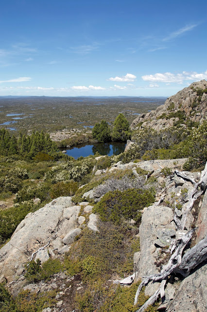
We were glad to get out of the fire zone, and into the untouched Blue Peaks area, by early afternoon. Once there, with our tents and tarps set up in the beautiful, familiar pencil pine grove, the bustle and busyness – and some of the sadness – started to fall away. And Mick began to beam, pretty sure that his idea was as genius as it was unusual. On a gently warm, sunny afternoon it wasn’t difficult for the rest of us to agree.


This being a first time visit for the other two, Mick and I pointed out a few of the area’s features to Larry and Ken. While we did so it struck me afresh that the most obvious characteristic of the place is actually its subtlety. Even the “peaks” of its names are understated hills more than peaks. But get your eye in here, and the light, the lakes, the clouds, the wildflowers, the birds, the distant mountains and the depth of the views, will do their work on you.

As it was only a week shy of the longest day, our evening meal was under way hours before sunset. I’d brought along a special birthday wine for Mick, and Larry had brought some brandy, so the celebrations began. Later, feeling suitably mellow, Larry and I decided to explore some of the nearby pools and pencil pines with our cameras. Mick, defying his increasing years, chose to take Ken to the top of one of the “peaks” for sunset.


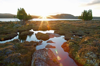
[Sunset over lakes and pools, Blue Peaks] 
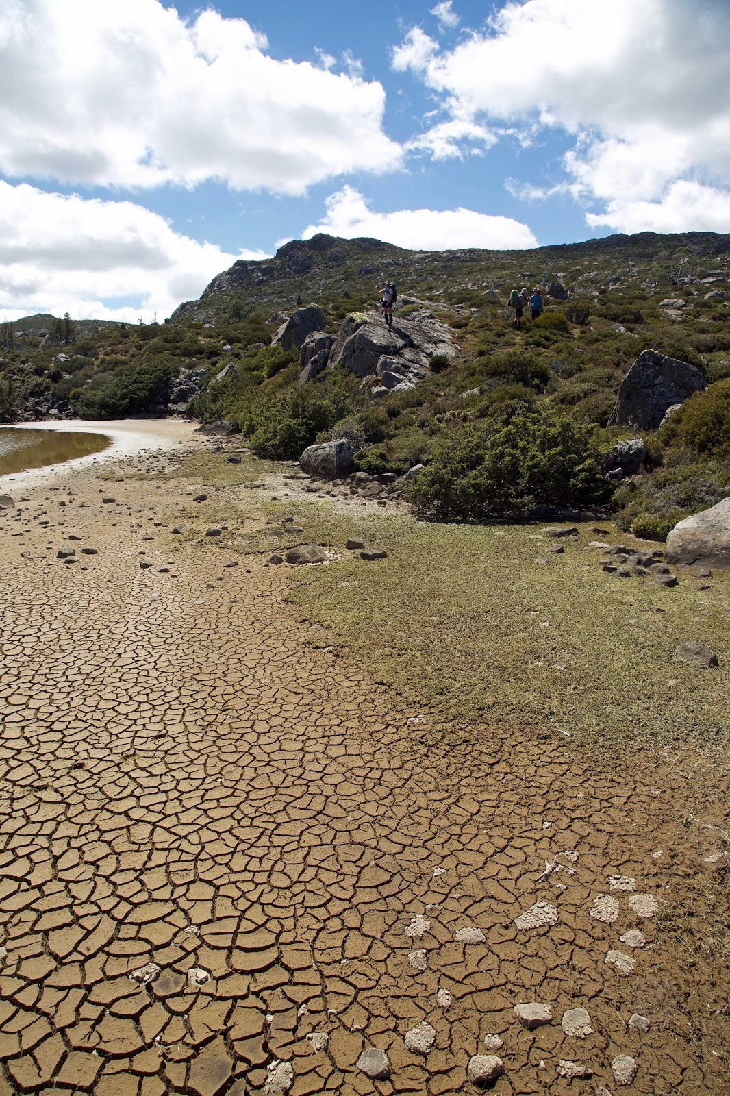
Next day the sun slept in. Given the low cloud and scudding showers, we followed suit. When we finally emerged, a kitchen tarp set up allowed us to breakfast and socialise in the dry for most of the morning. While mosquitoes threatened to keep us busy, they turned out keener to buzz than to bite.

After lunch we overcame our lethargy, put on some wet weather gear, and went for a wander in the light drizzle. We walked westward at a slow amble, the pace determined by the small wonders that kept gripping our attention. Scoparia (Richea scoparia) was blooming everywhere, its delightful flowers the antithesis of its dense and fiercely prickly foliage.


[Scoparia's multi-coloured blooms] 
At our slow pace we began to notice a few unusual things. Here and there we spied skinks scrambling over the prickly foliage to lick and nibble on the sweet blossoms, apparently pollinating them in the process. Wallabies too seemed to have a close relationship with the scoparia. I’ve certainly seem them supping on the sweet blooms. But we also began to notice that many of the bushes had been physically modified – presumably nibbled and trampled by the wallabies – to make highly protected nests.

Traces of wallaby fur and nearby scat mounds were further corroboration of that assumption. And nearly every “nest” – and we saw dozens of them – was sheltered from the prevailing westerly winds. That, combined with the numerous pads and pathways created by wallabies and wombats, led us to consider afresh the definition of the word farming. Such adaptations of the landscape certainly bore some of the marks of basic farming.

[Mick ponders a wallaby "nest" in scoparia] 
Wanting to earn our evening meal, we wandered further off, doing a loop around some lakes and low hills for another couple of hours. It was hardly exhausting work, but it allowed us to feel justified in further feasting once back at camp. Expensive wine, soft cheeses, biscotti, smoked mussels and oysters are hardly your usual bushwalking fare, but we’d all come prepared to celebrate!

The evening turned mellow in more ways than one, as the surrounding hills shrugged off the clouds, and wide, benign skies opened up around us again. Even the mosquitoes seemed to join in the celebration. At one point hundreds – perhaps thousands – lifted into the sky above our campsite, spiralling and swirling like a murmuration of starlings. We watched amazed, unsure what it signified, except that while they were up there they weren’t down here bothering us!

If we needed any confirmation of clearing skies, we had it when the night turned cold, and yet again I had reason to regret taking a summer weight sleeping bag into Tasmania’s high country. A freezing night might have been one reason we got going early. But there was also the sense that Mick and I needed to show the “newbies” a bit more of what the area had to offer. What better, we reasoned, than taking them via a few named lakes (Middle and Little Throne), past a named 
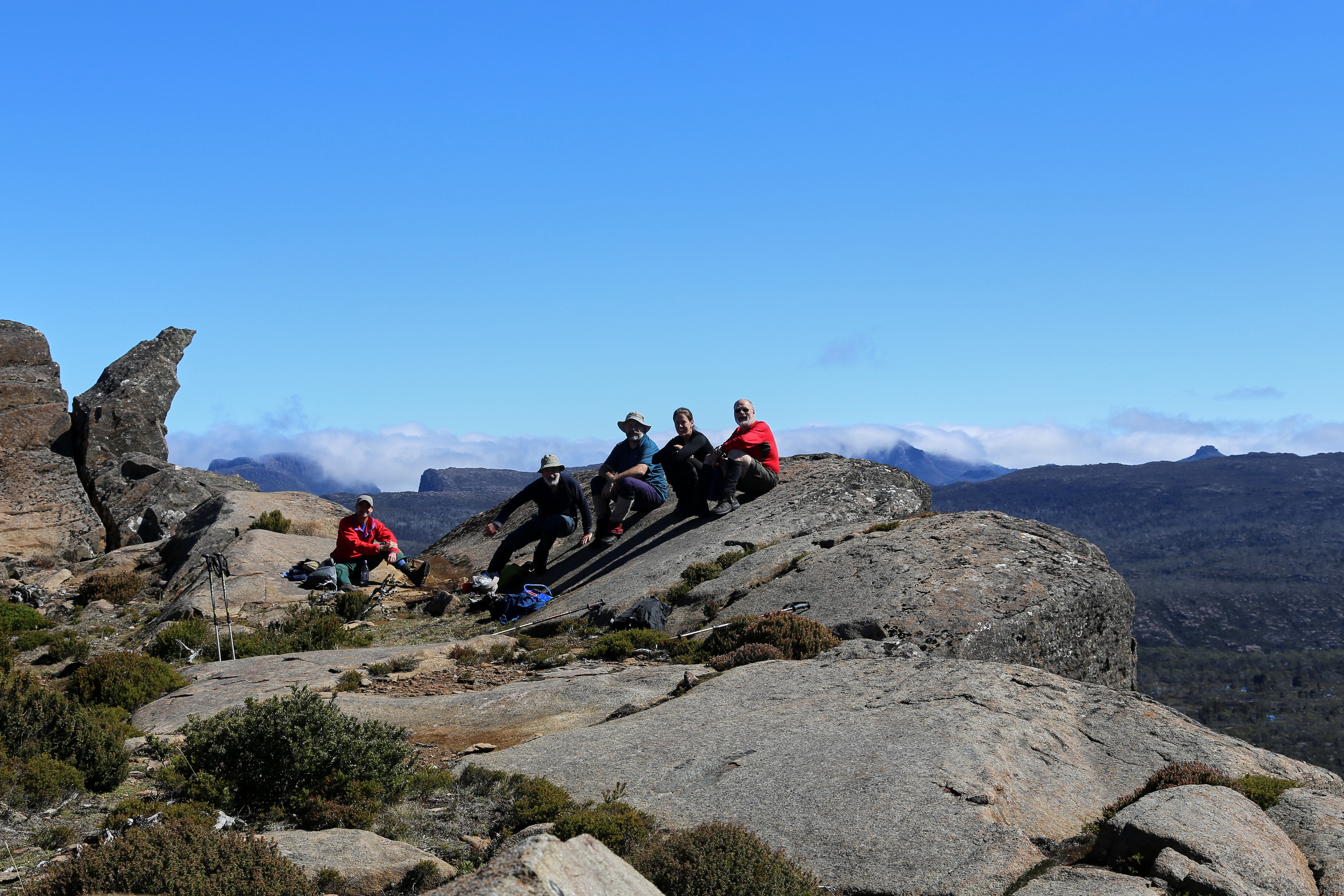
mountain (Turrana Heights), and to an (unjustifiably) unnamed peak.


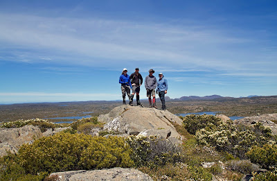
[Near the unnamed peak] 
The day was a gem, in more ways than one. The deep blue sky stayed clear all day, apart from a decorative schmear of cirrus cloud. With only day packs, and in no hurry, we strolled easily from lake to lake, hill to hill, chatting, stopping for photos, or scroggin, or just because we wanted to. Still, it was well before midday that we found ourselves scrambling to the top of our destination peak. It was as sensational as we remembered, with literally hundreds of lakes dotting the plateau beneath us, each reflecting the blue sky back to us.

Over lunch our eyes roamed south-west towards the Walls of Jerusalem. On such a day those mountains seemed achievably, tantalisingly close. We looked at our maps, traced a potential route or two, then went back to our lunch. That’s how easily a trip plan is hatched … but that’s another story.


[On top of the unnamed peak, with the Walls behind] 
With so much of the day left, we thought we’d go back “the hard way”, or at least a different way, via a hill we’d never been to, and then on to Little Throne. After a while we fanned out widely, each taking his own off-track route vaguely towards Little Throne. In the process I almost literally stumbled across the most enormous cushionplant I have ever seen. The other guys were maybe a hundred metres away from me, but I just had to call them down to see this spectacular marvel.


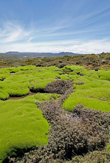
[Part of the vast cushionplant] 
Covering an area of at least 30m by 25m, the cushionplant – more accurately a colony of cushionplants – spread gently downslope in one continuous ruckled carpet of vibrant green. The colony had dammed a small stream, creating a shallow pool upstream, with trickling flow beneath, through and around it, creating ideal growth conditions for the moisture-loving species. It’s possible it had grown here for around 800 years, a notion that staggered us, especially given their vulnerability to trampling, drought and fire. We felt humbled to be in the presence of this giant dwarf among plants, and left with the sense that its exact location should be left unspoken. Some secrets are best kept.


[Cushionplant, pool and mountains] 
Before long Little Throne came into view. Mick and I, familiar with the usual route up the slopes of this twin-peaked, mini-mountain, thought we might try a different approach. Given that we weren’t coming at it from the usual angle, that made sense. Or at least it did until we started to ascend. Then the scrub proved thick and unfriendly, and we were hot, scratched and sweating by the time we hauled out on top.

So when we finally got back to camp, we were feeling well justified in helping Mick polish off the last of the birthday food and wine. It was a fine thing to be still in that wonderful place, winding up the 50th celebrations in style. Yet for everything we’d brought to the party, we’d been given far more by this wonderfully generous place. Good choice Mick!