Showing posts with label Pencil Pine Tarn. Show all posts

Friday, 16 April 2021

Central Plateau Variations: Part 3


[Who else has walked here?]

It’s rare to walk the Earth and not be following in the footsteps of others. At our first campsite, we’d sat relaxed and content – when the weather allowed – and imagined the Palawa, Tasmania’s Aboriginal people, doing much the same over tens of thousands of years. The shelter, the water, the hunting, the clear views, would all have made this a wonderful summer place. What stories, songs and dances must they have shared here, and passed on for countless generations?


[A place of contentment]

For the Palawa, European invasion stopped all that, whether though disease, forced eviction, or deliberate killings. Others would now eye off this high country for their own purposes, and they did so quickly. In the 1830s, when G. A. Robinson (the so-called protector of Aboriginals), travelled through the Central Plateau to round up any remaining Aboriginals, he noted that “wild cattle was seen grazing … and several young calves appeared among them”. 

So this “empty” Central Plateau became a favoured place on which to summer livestock. It’s estimated that between 1860 and 1920, up to 350,000 sheep and 6,000 cattle were summered up here annually. This is tranhumance on a grander scale than I’d ever imagined. Gradually cattle became more highly favoured than sheep, and by the late 1870s, settlers from the Mersey Valley and surrounding districts had acquired cattle grazing leases on the plateau. They built tracks such as Higgs Track, Warners Track and Dixons Track so they could drive stock up to the high country each summer.

But as we were discovering first hand, the “warmer” months on the plateau can still be harsh, making navigation difficult. Around 1913 a farmer from Meander named Charles Ritter, who had leases in the Walls of Jerusalem area, thought to make a safer all-weather drove route from the top of Higgs Track/Ironstone Hut area to the Walls. It was probably completed by 1918, and became known as Ritters Track. While it was called a track, I had long wondered whether it was ever more than a series of large rock cairns that could be followed even in rough weather. On our fourth day, we were hoping to find out for ourselves.

[An old sketch map by Keith Lancaster, showing Ritters Track]

The night had been exceedingly windy, and none of us had slept much. Jim wasn't feeling great after a poor sleep punctuated by some unwelcome toilet trips in the dark. We’d already decided to adapt our schedule, allowing for another night here at Pencil Pine Tarn, and a short wander today. That meant Jim could stay back and “keep our camp secure”, which he generously volunteered to do. The rest of us would pack lunch and a day pack, and go in search of Ritters Track.

Three years earlier we’d half-heartedly looked for some cairns between here and Long Tarns. That time we’d only had some rough, third-hand notes, and our explorations hadn’t allowed us to say with any certainty that the cairns we found were part of Ritters Track. This time, we had not one but two lots of GPS data indicating the supposed locations of Ritter’s cairns. The only thing against us was the weather, which remained showery and ferociously windy: in short exactly the kind of weather Ritter hoped his track would deal with.


[Tim contemplates the route]

Tim and Larry, our two GPS-bearers, lead the way, at first taking us almost east, seemingly back to where we’d come from. I expressed my surprise, but Tim assured me we’d soon swing south. And once we’d picked up a cairn, we’d start heading more south-west. 

Before long one of our navigators signalled us to join him. According to his GPS, we were within 20 metres of one of the cairns. But what were we looking for? A pile of rocks in a landscape made of rocks? And rocks that have been glaciated, ice-shattered, and scattered about willy-nilly over aeons? The five of us wandered about, a little clueless, until someone finally had their eureka moment. 

[Surely a Ritters Track cairn?]

We hurried over towards an obviously human creation: four or five rocks piled high atop a large boulder, forming a rough and wonky pyramid. If the cairn’s size wasn’t the clincher, the mop of long, grey/green lichen on the rocks was. This indicated it was no recent or random cairn, but one put here deliberately, and many decades ago.

[Tim and Larry spy out the next cairn]

The next couple of hours saw us slowly following our navigational nerds from cairn to cairn. Sometimes the next cairn was visible from the current one, but at other times we were glad to have the GPS data. This was not the sort of “track” that, once found, you could easily follow. Apparently Ritter didn’t choose a straight-line route towards the Walls of Jerusalem (which today was clear to see ahead of us). Rather he kept to higher, less boggy ground, winding around the plateau on ground over which cattle could more easily move.

[A clear view towards the Walls of Jerusalem]

Another matter sometimes confused us. We found multiple other cairns dotted across the landscape. Some we considered Ritteresque: good copies, but not originals. Others were mere wannabes: poor imitations that lacked size or age, the creation perhaps of bushwalkers or anglers. Our rule of thumb was that a true Ritter cairn would be substantial, vaguely pyramidal, made with care, and bearded with lichen. We came to admire the labour that Charles Ritter, presumably with the help of his fellow drovers, had put into building the many dozens of cairns. The heavy rocks would have taken some effort to move, and the conditions for doing that work would seldom have been ideal.

[Libby inspects another genuine Ritter cairn]

As we walked, we imagined driving cattle through this terrain. How different it would have been to walk or ride here accompanied by the sound of hoofs and mooing; the steam from their breath; the swish of their tails; the slop of the slush beneath their hard hoofs; the smell of dung and drover alike. We could admire, celebrate even, the hard labour of these cattlemen, without wishing that this was still happening. Clearly driving and grazing cattle between here and the central Walls – where the best grazing was found – made a mess, and altered the landscape hugely. The unsustainability of the practice, both environmentally and economically, led to grazing being prohibited above the 3000ft contour (914m) in 1973. 

[Tim and Merran at our lunch stop]

While it had been fascinating to follow the footsteps of Ritter, after lunch it was time to complete our off-track loop back to the campsite. We were beginning to wonder how another grey-bearded fixture was doing. We found Jim relaxing in the sun, which had finally made a welcome return. As Tim placed his small solar panel in the same patch of sun as Jim, I remarked that we now had two solar collectors. Then, over a relaxing afternoon tea, we swapped stories of our day. Jim noticed that a couple of us were red in the face, and when we conjectured that a combination of windburn and sunburn might be to blame, he was all the gladder for his rest day.

[Two solar collectors hard at work]

When the shade from the pines started overtaking us, we followed the sun up the hill. It was good to gain a little altitude, to change our perspective, and to feel a windless sun after 48 hours of gales. Eventually we wandered back down to the camp, and we were soon off to our tents. How good it felt to be in that now quiet space, without wind tearing my every thought away.

[A calm Pencil Pine Tarn]

In that calm state, I began to ponder on our walk, and to think about the footsteps we had followed to this point. Whether it was those of the Palawa, those of the cattlemen, or those of the pioneer bushwalkers, the ones who were here before us are now gone. Without feeling at all morbid, I apprehended afresh my own impermanence. None of us – grey-bearded or not – will hang around even as long as Ritter’s cairns. Sooner or later each of us will follow in the footsteps of those who are gone. 

It was in a time of pandemic, nearly 400 years ago, that poet John Donne reflected so powerfully on this. 

No man is an island, 

entire of itself, 

every man is a piece of the continent, 

a part of the main; … 

any man's death diminishes me, 

because I am involved in mankind,  

And therefore never send to know for whom the bell tolls; 

It tolls for thee. 

Tuesday, 20 March 2018

Crossing the Plateau 2: Downtime


There are some activities that you would immediately associate with off-track walking in the Tasmanian wilderness. Lolling about, playing cards, daytime snoozing and planking might not be among them. When day 3 dawned on our walk across the Central Plateau, those things weren’t uppermost in our thoughts either. Rather, once we’d conferred about when to leave and how far to go, we expected to walk further into the unknown.


[Conference time: Pencil Pine Tarn] 
The forecast was for wind and rain, but mostly later in the day. So getting going early, and finding a sheltered campsite before the change, seemed the obvious choice. But after breakfast, with an ominous build up of cloud and a rising wind, our group conference took an interesting turn. We outlined the options, then asked each person to express their preference. Nearly everyone was for packing up and leaving, albeit without huge enthusiasm. But at the end of the discussion one walker mentioned some hip discomfort after yesterday’s walk. When we combined that with our general ambivalence and inertia, we unanimously reversed our decision. We would stay another night in the shelter of this lovely Pencil Pine Tarn campsite. Ain’t democracy grand?

Having decided we weren’t going anywhere, we promptly went for a long walk around our home lake. We figured rain and wind might soon make that impossible, or at least unpleasant. Apart from anything else, I was curious to see if there were any other campsites near this tarn. (The short answer was yes, but our’s was definitely the Paris end of town.) Nonetheless we found some other fine stands of pine, and a few delightful pools. We also disturbed some swans and their cygnets, and the odd wallaby.


[Mick explores a nearby tarn] 
At one stage I found three of our party down on hands and knees, intently looking at something. I joined them, and found a very large, oddly-coloured katydid. 


[What have we here?] 
It was a mountain katydid (Acripeza reticulata), new to us but apparently common in eastern Australia’s high altitude grasslands. When they’re threatened they lift their wing-covers to reveal bright crimson and blue stripes, and the males emit a warning call. We mustn’t have threatened them overly, as they allowed us quite a close inspection before continuing about their long-legged business.


[A female mountain katydid - photo: Mick Adams] 
Despite our decision to stay another night at our tarn, a few of the group couldn’t resist reconnoitring the potential onward route. Tim D deployed his phone’s map app – a better option than a paper map in the strong wind that was now blowing – and tried to match what we could see with the terrain shown on the map. From where I stood, I was pretty sure I still heard “southish” and “westish” mentioned.


[Discussing our navigation options] 
With tomorrow’s navigation nailed (!) we circled back to the campsite, and settled down to a brew and banter session. At such times our talk normally centres around food (briefly) and bushwalking gear (at great length). But this time our gear chat unaccountably faltered, and we somehow found ourselves talking about walking fitness, including core strength.

Now up until a few years ago, I didn’t know humans had cores. I thought that was purely an apple thing. But I’d recently discovered not only that I had one, but that it could be strengthened. Even more, I’d found that as I get older and my muscle tone isn’t quite what it once was, having a strengthened core is a “good thing”.

So I breezily mentioned my discovery of core-strengthening exercises, and notably planking. What ensued was an hour of (mostly) harmless fun, as we started a plank challenge. While no-one in our group would confess to being competitive, they lie! An hour later, after much pain and huffing, we declared Ken the winner of the Pencil Pine Tarn Plank Challenge. He had somehow managed to hold a plank for 4 and a half minutes. Merran and Libby were the other medalists, not that anyone was being competitive, of course.


[TimO perfects the "tired and prone" position] 
The rest of us took some consolation in our ability to lie prone for even longer. TimO seemed particularly happy to adopt and hold the prone position, even if some claimed he had simply collapsed in an exhausted heap. Either way, he set such a good example that I decided to try the same in my tent. Unfortunately it didn’t work that well, as the next (non-competitive) activity – four-handed 500 beneath the close-by tarp – soon got very raucous.

Late in the afternoon the promised wind and rain gatecrashed the party, and the 500 players retreated beneath the larger tarp. The rest of us stayed tent-bound. And now we could all appreciate the wisdom of staying here an extra night. While the rain pelted down, and the wind roared around us, our tents stayed well protected. We even managed to cook in between showers, and socialise for a time over dinner.

Fresh showers finally drove us – not entirely reluctantly – back to our tents. And before the light had fully drained from the sky, I’d drifted back to sleep. Downtime can be tiring, you know.

Wednesday, 28 February 2018

Crossing the Plateau 1: Starting with the Known


So I am on the plateau again, having gone round it like a dog in circles to see if it is a good place. I think it is, and I am to stay up here for a while. – Nan Shepherd
How blithely we speak about mountaintop experiences, as though there’s nothing but serenity to be had on summits. Certainly I’ve experienced joy, and elation, and a good degree of satisfaction on getting to the top. But like most walkers and climbers I know, I have a dirty little summit secret. Even as I sit there my serenity is tempered by restlessness. I simply can’t resist planning where to go next.


[The Mountaintop where it began, looking to the Walls] 
That’s exactly what happened last December, when four of us sat on top of an unnamed mountain near Tasmania’s Blue Peaks. As our eyes scanned the wide horizon, they were magnetically drawn towards that other favourite walking area: the Walls of Jerusalem. How about we walk across the Central Plateau from Lake MacKenzie via the Blue Peaks and on to the Walls?

If that was the germ, the infection soon spread. Those who hadn’t been on that December walk all wanted in. Via email we discussed potential dates and other logistics. That’s usually where the drop-outs start happening, but not this time. While some of us had previously walked into the Walls from Lake Ada or similar, this exact route was new to us all. And no-one wanted to miss out.

The logistics of making this a one-way walk already required some mental gymnastics. Added to that two of our walkers needed to come in late on the first day, and leave a bit earlier at the end. So the plan was to pick up one of their cars and take it, along with one of ours, to leave it at the Walls carpark. That meant starting off in three walking groups, the car shuffle walkers, the non-shuffle walkers, and the late walkers. Confused? So were we, but it all worked out.


[Sunset-lit clouds, Blue Peaks] 


One of these times we’ll get to “our” Blue Peaks campsite and find someone already ensconced. (Note to self: stop extolling the virtues of this place!) Thankfully, given we were a large group, this wasn’t such a time. In dribs and drabs we finally got to the site, and settled ourselves for the adventure ahead.

If our minds had been ruffled by travel and logistics, the sunset from our campsite smoothed and soothed them. The stunning light show went on for nearly an hour, after which Tim D and I got down to discussing walking route options. 


[Sunset from Blue Peaks campsite] 
All involved the unknown, as well as the unnamed: that is the unnamed peak that was the site of the walk’s genesis. We traced a vague route on the map that would take us between Turrana Heights and the unnamed peak, then down towards Lake Lexie. After that things got fuzzier, with words like “southish” and “westish” featuring. But we did know that we were heading towards Mount Jerusalem, and that we’d have to dodge plenty of lakes and any thicker bits of forest or scrub. Tim’s other general thought was to stick to higher country, to avoid both bog and scrub. Given low water levels in the lake near our campsite, we figured boggy ground wouldn’t be much of an issue.

It was strange to be packing up to leave Blue Peaks the next morning, given it was usually our base for a number of days. Strange too not to know where we’d be camping that night. Internet searches hadn’t revealed a lot about our route, but then that was part of the adventure. We knew about a very old cattle drove route known as Ritter’s Track. But as well as it being south of our intended route, we also knew it was sketchy. And while there were sporadic cairns along the route, the ground trail itself wasn’t likely to offer better going than off-track walking. So off-track it was, firstly around our nearby lake, then off via Middle Lake and Little Throne Lake towards the unnamed peak.

Although slowed a little by carrying full packs where we normally took day packs, the going was easy, especially as the lakes were so low that we could cut across them at times. A couple of hours in, and just before the climb that would have taken us up our unnamed mountain, we veered “westish” and dropped down to a small, pine-encircled tarn. We were now officially walking where none of us had ever been before.


[Low tide on Lake Lexie] 
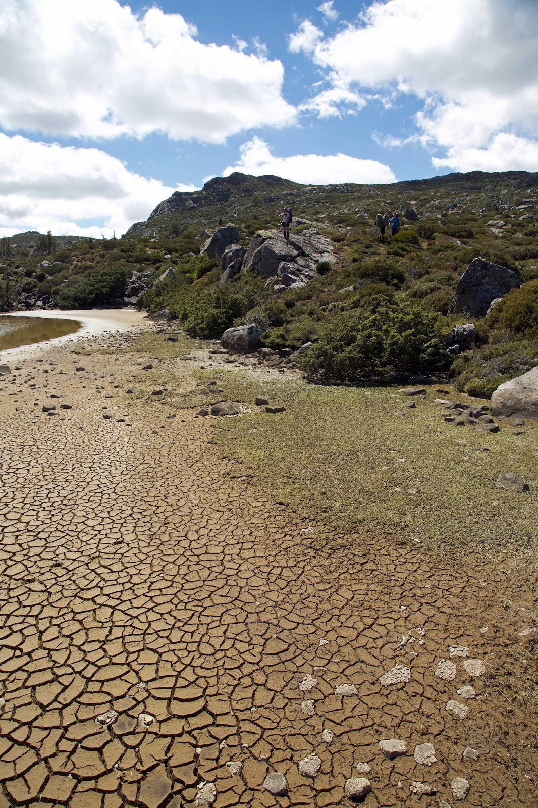
The weather was clear, the sky blue, and out of the stiffish breeze the day was growing warm. After a short scroggin and drink break, we hoisted packs and walked on towards the more sizeable Lake Lexie. We dodged around its long and sometimes convoluted shores, the shallowest of which looked like mud flats at low tide. Some parts had dried and cracked so much that they gave a convincing impression of a desert.


[Yes, the Plateau was dry!]  
Towards the end of Lake Lexie we found a lunch spot that offered some shelter from the growing wind. As we ate we discussed how far we should walk before settling for the night. Opinion here was divided. Some were keen to start looking for sites sooner rather than later; others wanted to head as far towards Long Tarns as we could, knowing that late tomorrow the forecast was for rain and wind. The Walls themselves offered more shelter, if we could get there before that expected weather change.

Sometimes, however, a gift horse appears. And that was the case when we came to Pencil Pine Tarn. To my mind, it being only 2:30pm, this was a bit early to stop for the day. But once we’d wandered up slope to the pencil pine forest that had given the tarn its name, we all decided we’d be mad to miss the chance to camp here.


[The sheltered campsite near Pencil Pine Tarn] 
The beautiful, ancient-looking pencil pine grove offered superb shelter from  nearly every quarter. The site had obviously been used before, with logs and rocks arranged as camp furniture, and (sadly) signs of a past campfire. Apart from fires being illegal across this whole “fuel stove only” area, I shudder when I see signs of fire anywhere near these irreplaceable pencil pines. But I calmed down once I’d spent a few minutes among the pines, breathing in their rich, resinous scent. It seemed we had landed on our feet with this campsite.


[Relaxing at Pencil Pine Tarn camp] 
Once we’d set up tents and tarps, Tim O and I declared we were going down to the lake for a swim. There were two surprises with that. Firstly everyone else said they’d do the same, and secondly the water proved to be only a foot deep, with the tarn bottom’s mud about the same depth. So our “swim” ended up being a hilarious exercise in getting both wet and muddy. At best we managed to float on our backs, propelling ourselves along like inept, over-sized otters. Still a wash is a wash, and even Jim – not a keen swimmer – stayed in the whole time. We all came out glad he’d made the effort, and more than happy to settle back in to our brilliant campsite.