Sunday 22 February 2015

Dreamwalking

Grounded: (adjective) sensible and down-to-earth; having one's feet on the ground; (verb) to confine (a child) to the house as a punishment. (Collins Dictionary)

For the past 6 weeks I’ve been grounded. In the aftermath of our Mt Anne “epic”, and the ankle injury I sustained there, I’ve had to be very sensible about how I put my feet on the ground. And it has involved enough confinement to make it feel like a punishment.


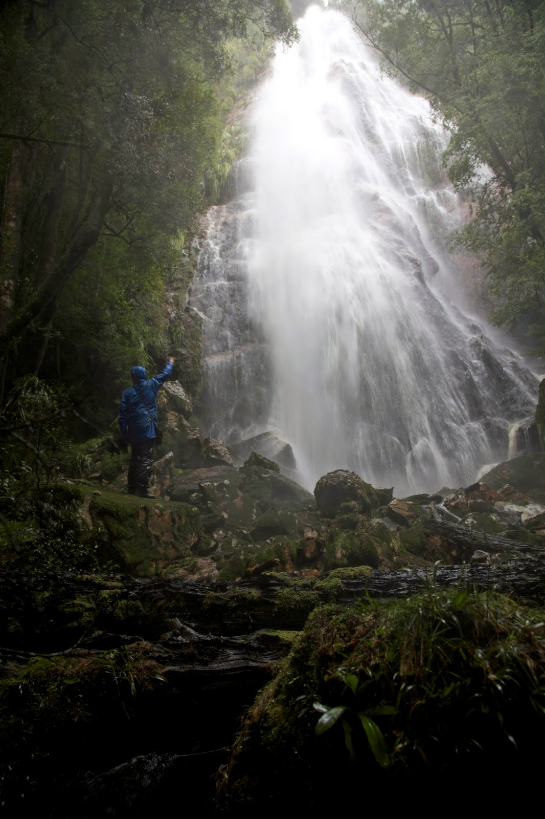
[Let me outa here! I need to walk!] 

The backstory can be found here Mt Anne Epic Part 2But to put it simply, politely, I badly sprained my ankle. According to the physiotherapist I probably tore my soleus muscle. This lurks somewhere beneath the Achilles tendon, near quite a few other equally unpronounceable bits and bobs. And I didn’t confine the damage to that muscle. The harm from the initial twist spread to quite a few other unnamed parts, thanks to the steep, rough and hot 10 hour hobble back to the car. It all hurt, and I could barely walk for two days after getting home.

So while the summer variously sizzles and fizzles itself out, I’ve been slowly recuperating. It has involved more “thou shalt nots” than “thou shalts”. I can do some simple (and boring) physio exercises and I can wear an ankle support brace. But I can’t run, and I can’t walk anywhere too rough. Nor can I walk very far or carry much weight on my back. And that has meant no overnight bushwalks since early January.

So what does a passionate walker do, at the height of the walking season, when that activity is curtailed? For a start I dream of walking. I pore over maps, plotting and planning walks that I WILL DO when … I also walk vicariously, listening to friends talking about their trips, reading others’ accounts of their walks.
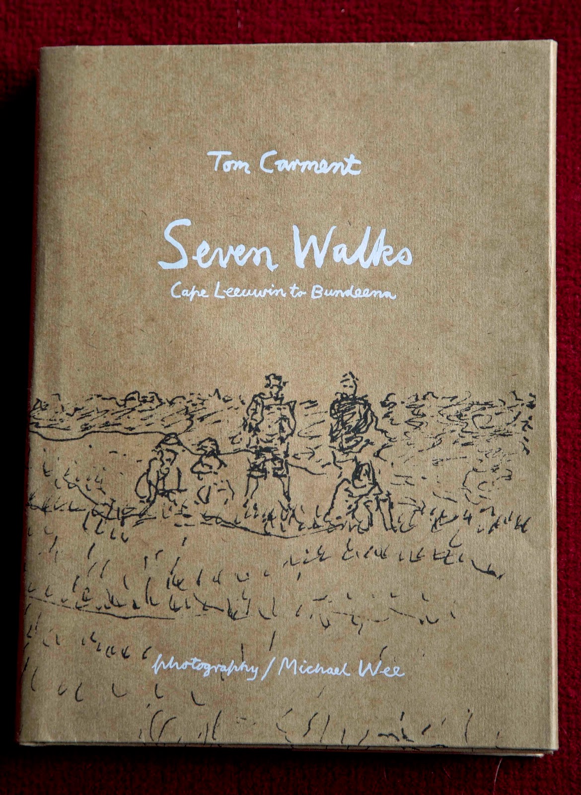

My dreamwalking is always being fed by books. But during my recent confinement, Tom Carment and Michael Wee’s “Seven Walks: Cape Leeuwin To Bundeena” has happily filled a void. As well as its beautiful and artful presentation, I am enjoying its spare, wry observations about bushwalking in Australia. I laughed, for instance, at Carment likening the randomly gathered walkers on the Overland Track to “the cast of their own six-day play.”


English poet Simon Armitage’s “Walking Home” is a delightful take on the long distance Pennine Way. Armitage walks from the Scottish border to his Yorkshire home, giving poetry readings each evening in return for his bed and board. It’s probably only the English weather that creates any semblance of adventure here. But this book is more about the characters and places Armitage meets along the way than it is about the walk itself.
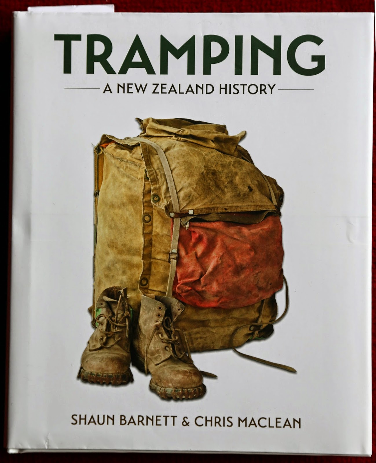

“Tramping: A New Zealand History” by Shaun Barnett and Chris Maclean is a monumental – and beautifully illustrated – account of tramping in New Zealand. This is a book to dip into endlessly, whether to learn the origins of the word “tramp”; to hear of the unique place of huts in NZ walking; or to admire the feats of pioneers crossing the Southern Alps. I managed to bring the book back from New Zealand late last year as “hand luggage”. If you want to try the same, I’d suggest you do some arm strengthening exercises. This wonderful book weighs in at almost 2kg!


Despite this wealth of indirect experience, I've concluded that it’s only actual walking that is properly good for your body and soul. So last weekend I donned my boots – and my ankle brace - and fought off my growing cabin fever via an exploratory walk on the mountain. 
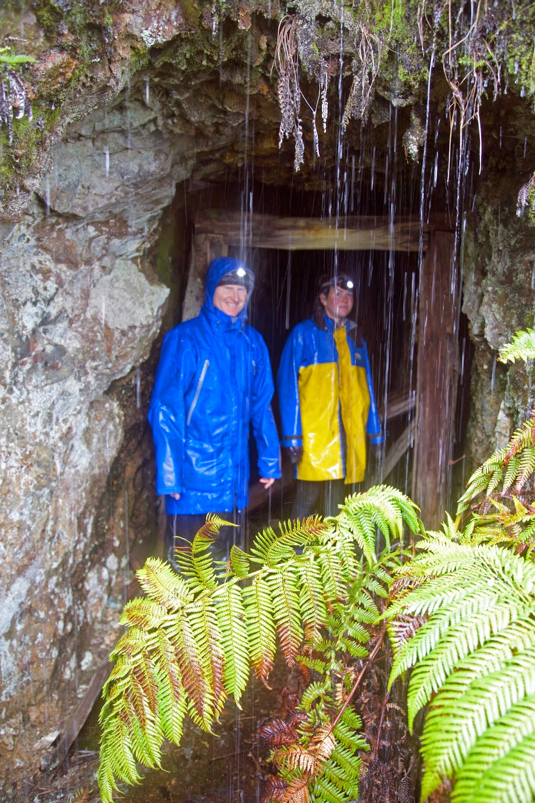
It involved some steep, rough slopes (don’t tell my physio!), but the reward was the discovery of two mountain huts I’d never been to. I survived the walk well enough to imagine that my next book just might be a bushwalker's log book!


[Log book in a hut on kunanyi/Mt Wellington] 

Sunday 8 February 2015

A Walk in the West: Part 2

[... continuing the Fraser Creek Hut story from last winter]


[Luxuriant West Coast rainforest] 

It’s like the shipping news for bushwalk huts. Always mornings in huts seem to commence with a comparative report on snoring levels. The men – this writer included – seemed to score at least reasonable decibel ratings during the night. But gender equity came into it, with at least one of the women also snoring to measurable levels.

That formality dispensed with, Terry got us up and going by boiling a billy. He had what sounded like a packed program for the day – a couple of waterfalls, a few mines, a bit of off-track walking, and maybe a mountain – so he was keen to get us out there. Since it was all new to most of us, we were happy to be guided by Terry.

The weather was typical west coast: cloudy, showery, with the odd patch of brighter sky. Regardless, even if the rain held off, we would need our rain jackets and overpants. The rainforest’s dripping undergrowth would ensure we’d be soaked within the hour.


[Terry tutors me in King Billy paling splitting] 
At our first stop Terry gave us King Billy pine splitting lessons. Using an adze-like device, with its sharpened edge perpendicular to the handle, he showed how a length of downed pine could be split into palings. We each had a go, surprised at the workability of this beautiful honey-coloured timber.

We then continued up through the wet forest to a small clearing, our high point for the day, before continuing across the slope. Soon we were in thick and luxuriant rainforest again, everything a shade of green or hazel.


[In the forest, near our high point] 
We were walking in misty cloud, but had the feeling that empty space was off to our left. Then there was a lift, and we found ourselves staring down the steep and slippery decline that would take us to the Curtin-Davis mine.

An 1895 report on the mine doesn’t exaggerate when it says “the approach to Curtin's tunnel is extremely precipitous”. The writer went on to report "good surface shows" of iron and copper ores, ‘though he was possibly more enthusiastic about the potential for mine operations to harness the copious water of the area.

At the time of my visit to the mine a large body of water was leaping over this magnificent mountain gorge. The whole of the area … is covered densely with myrtle, sassafras and leatherwood trees.

We stared out over that very scene, and had equal admiration, if dissimilar ambitions for its future. Then, having descended, we had to climb a little, with the aid of some fixed rope-lines, to reach the entrance to the old mine. There we donned head torches and carefully picked our way into the horizontal mine shaft.

Terry took care to warn us about the large gaps in the floor, and once we were on solid ground, we stopped and looked around. There were two surprises: first the flashes of colour on the mine walls (what looked to me like copper oxide); and then the invertebrate that had made the shaft a comfortable home. The latter was a very large Tasmanian cave spider (Hickmania troglodytes), complete with its sizeable egg sac, hanging like a frozen tear drop from a thread of silk. This remarkable spider can live nearly as long as we humans can. And its nearest relatives are in Chile, meaning its ancestors date back to Gondwana. That makes it ancient in more than one sense. 


[A Tasmanian Cave Spider with egg sac, in Curtin-Davis Mine] 
I’d seen one of these spiders before in a cave, but had not expected to see one in a mine. I had to chuckle that even in this human-made environment, I was focussing more on wildlife than engineering achievements. I’d done the same once in Parliament House in Canberra, giving most of my attention to the Bogong moths that were flying around the chamber’s enormous lights, rather than the political pomp.

At the base of the slope the North-East Dundas Tramway once ran. It took ore from this and other mines back to the town of Dundas. It remains a remarkable engineering feat, given the steep and sodden nature of this place.

Even though the line and most of the bridges are no longer extant, the former tramway provided a wide and level means of reaching Montezuma Falls. Given the amount of rain that had fallen, we were keen to see this apparently spectacular waterfall. We weren’t disappointed. A prodigous amount of water was pouring over the 110m drop, enough to make us glad of our head-to-toe waterproofs as we gawped from the viewing deck.


[Montezuma Falls, Tasmania] 

Back in the 1920s, before the line was closed, rail trips to the falls were a feature for tourists. A late 1920s Mercury story tells us:

This little railway is a “show” line of the highest order, for it dives quickly amongst the mountains, brushing the fringe of the forests, and at one point giving a near view of the handsome Montezuma Falls – so near that the spray actually dashes at times against the carriage windows.


[Montezuma Falls with train] 
Today walkers, mountain bikers and a few experienced 4WD users still use the track. Where the bridges have gone the challenge for 4WD and MTB users is considerable. We stopped to watch as a couple of vehicles tried to cross one creek. By the time we left the score was Creek 1, 4WDs 1. One vehicle had decided – after two attempts – to give up on the crossing.


[Sheltering from the rain in an un-named mining adit] 
Our own (new) challenge was to leave this easy, broad track and take to the steep slopes that would lead to our next destination: Fraser Falls. We soon found out why it’s a seldom-visited waterfall. First we had a long, uphill, off-track steeplechase, just to get near to the falls. Then we had a slippery, muddy, nasty descent to get somewhere near to seeing the noisy-but-hidden falls.

With much grumping, slipping and sliding, we eventually reached a point where the falls could be seen. Smaller than Montezuma, but still high, impressive and very full, the falls were surrounded by thick, wet forest. Once we’d got near, a couple of us had to find “the” photographic view of the falls that would make the trip worthwhile. Naturally that involved some more scrambling, and negotiating slimy rocks above a swiftly-flowing stream. By the time we got there we were exhausted. But we took our photos, then slowly gasped and grunted our way back to the descent point.


[The seldom-visited Fraser Falls] 
It would be great to say that Fraser Falls, being on Fraser Creek, was within cooee of the hut. It wasn’t. So it wasn’t “soon” that we finally pushed open the door to the hut. But I can end by saying that we did sleep very soundly that night, whatever the decibel rating of the snorers.

Sunday 1 February 2015

A Mt Anne Epic 4: The Walking Wounded

At dawn the light is dull, sluggish. I’m the same, but make myself go out with my camera to check out the show. The valley is filled with slowly swirling cloud, but the tops are clear. It will be a fine, warm day once the sky shrugs off the valley’s blanket.


[Morning cloud burns off beneath Mt Lot & Lots Wife]
Tim and I wander across the shelf, looking for angles. I’m also testing my ankle, which feels walkable, ‘though the thought of carrying a full pack is daunting. We try not to linger over breakfast – there’s a long day ahead – but we rarely seem capable of breaking camp quickly. Apart from our desire to dry our tents before packing them, this place has a gravitational pull that makes it hard to escape.

It’s 9-30am before we wander up the slight incline towards the point where North-East Ridge meets Pandani Shelf. On the way we stop and chat with the only other people we’ve seen up here: two men with high-end photographic gear. We glean a couple of valuable tips, firstly how long they’ve taken to walk up from the road (6 hours) and secondly that they’ve taped their route with blue tape (which they intend to remove on their way back).


[Tim starts the descent. The road is just visible in the background. (Click to enlarge the image.)] 

We do a quick calculation of our return time, estimating 8 hours. That’s based on their fitness relative to ours, and how much injury and inexperience may slow us down. Just before plunging steeply through the forest we take a short detour to see if we can find Anne-A-Kananda, once the deepest known cave in Australia. (It has since been surpassed – only slightly – by Tachycardia and Niggly Caves, in the Junee Florentine system, a little further north of here.)  


[The Anne-A-Kananda sinkhole, with Lake Timk and Lots Wife]
The viewpoint gives only a hint of the huge hole beneath, and we don’t have the time to explore further. But we are still awestruck by the scale of the work done by mere H2O on this limestone ridge. We try – mostly in vain - to capture some of it photographically.

The “track” we’re aiming for – sometimes called the Bombardier Track – indirectly owes its existence to limestone. In the late 1960s a solo bushwalker went missing in this area. A caterpillar-tracked vehicle known as a bombardier, used by both the Hydro and mining companies for exploration, was co-opted to aid with the search. Unfortunately the walker was never found, and was presumed to have fallen into one of the numerous sinkholes in the area. However the track remains visible in some places, and the route is occasionally used by walkers like us.


[A 1960s bombardier, with HEC staff. (Ashton/National Library of Australia)]
The descent is long and steep, very steep. Trekking poles – just one for most of us - are extended. I’m using mine as an emergency brake, keeping some of the weight off my ankle. The rainforest is dense and deep green, with light filtering through myrtle beech and sassafras overtowered by old and gnarled King Billy pine. The pines have deposited a soft brown layer on the forest floor, and the undergrowth is mostly sparse, at least at first. We are making reasonable progress, although the downhill plunge is hot, hard and thirsty work. We welcome the shade, and take frequent drink stops. Outside this green haven the day is becoming warm and sunny.


[Tim finds shade on the descent through the forest] 

We stop for lunch somewhere towards the bottom half of the slope, ‘though not as far down as I’d hoped. After lunch the interminable downhill plunge continues, and the scrub thickens. The walk starts to become a tactical battle, a mental game for each of us as individuas, and as a group. Finding the route, now sparsely marked with blue – and pink and yellow – plastic tape, has become more of a task. Some of the tapes lead in contradictory directions. Lina is in the lead for a time, her first go at route finding. We’re pleased to be able to congratulate her on not getting lost.

But this victory is overshadowed by sounds of disgruntlement from elsewhere. Mick is having a hard time. Stumbling and grumbling, at one point he falls over outright, cursing loudly. We pause to help – once we’ve taken some photographs – and make “we’ll soon be at the bottom” type promises.


[Mick takes a tumble ... and we take photos!]
Eventually we do reach the toe of the slope, but it’s clear Mick is not well. He goes off to dig an emergency hole, returning a while later still not looking great. He’s clearly exhausted, as we all are, but we guess he’ll be okay. With that we plunge out of the forest and onto the buttongrass plain.

Five minutes into our 4km slog along the plain, Mick stops, drops his pack, and starts vomiting. There’s not much we can do but put a hand on his shoulder and mutter sympathies. After a few violent episodes, he manages to swig some water, take a few deep breaths, and gradually get to his feet. It’s the start of a long and almost impossibly hard return walk for him.

He is sick several more times. We pause often on a slow and seemingly endless march across the plain. Actually it’s anything but “plain”. At a few points there are creeks and scrub bands that interrupt the buttongrass. At these points the twin bombardier tracks, which were at times plainly visible, are suddenly unfindable; either overgrown or otherwise obfuscated.


[Paola on the Bombardier Track, with Anne Range behind]
Given that the tracks are at least 45 years old, we probably should be surprised that we can see any of them. The wider scene is quite stunning, even if we’re not in a position to really appreciate it. The whole north-western flank of the Anne Range rears up out of the surrounding plains and forest. She is imperious, majestic, this Queen Anne.

Tim and I talk about going ahead, finding the car, dropping our gear and returning to carry Mick’s gear. But each time he manages to rally enough to shrug the suggestion off, and to walk on for another few hundred metres. I’m wearing my GPS and can measure both our progress and the distance to the road. Our advance is agonizingly slow. Not for the first time I wonder whether it’s best not to know.

The afternoon heats up, and we beat on into the face of the sun. We keep trying to persuade Mick to just stop and let us come back for him and his pack in a short while. But he’s made of stern stuff – not to say somewhat stubborn – and he keeps finding a way to walk on.

When we finally agree that Paola and I will go ahead and come back once we’ve reached the road, we don’t manage to shake off Mick’s pursuit. As we enter the last little bit of scrub (of course there has to be something nasty before we finish!) we turn to see the rest of the group only 200m or so behind us. Mick’s going to do it all under his own steam.

Barely ten minutes after we reach the road, the rest stagger out of the bush and onto the road verge. If Mick is the crookest, no-one else is in great shape. Lina walks out, and lurches off to find a quiet spot. She is utterly spent, and not yet up to celebrating an incredible effort: her first excursion into some of the toughest country in a truly wild part of the world.


[Tim, Mick, Lina and Paola at the road]
It’s 7-30pm. We’ve been on our feet for 10 hours. We’re a long way from feeling elation. We’re just relieved that we’ve managed to hobble, stagger and persist our way out of the bush under our own steam. Next time we might try something straightforward.