Thursday 24 March 2016

Return to Blue Peaks 2: Slow and Steady

Travel, walking, sadness all take their toll, and none of us is ashamed to be heading to our tents by 8pm. Currawongs call reveille, but otherwise our camp beneath the pines is quiet. A deep stillness settles on the nearby lakes, which mirror twin hills. The peace of being here bears me swiftly towards sleep.
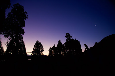

[Twilight beneath the pencil pines] 
The zip of a tent wakes me. I fumble with my torch, learn it’s 4am. That’s 8 hours of sleep, my fuzzy mind calculates. A good night’s rest, it continues. When it starts to add that perhaps we should all be up and about, I quickly hose down the idea. Instead I get out to relieve myself, and find Jim doing the same.

It’s cooler now, though not cold. The sky is filled with stars, but they’re oddly muted, untwinkling, as though seen through gauze. It must be mist or high cloud.

Our friend Tim D will be joining us later this morning. He’s estimated he’ll arrive by 10am. But as he’s never been to this place, I wonder if it could be closer to 11. So it’s back to the tents for a lie-in.

I lie a lot, doze a little, until voices start exchanging greetings and weather reports. I have a low-level glimpse of the lake out the end of my tent, and see what’s either low cloud or fog. Eventually I unzip the tent and emerge to find a breaking fog, and a couple of boiling billies.

We’re slow over breakfast, knowing we’ll be waiting for Tim D before we go anywhere. Tim O enthralls us with his adventures in breakfast cuisine. This time it’s bhuja and scroggin-infused muesli topped with liquorice, chocolate and milky tea. The less adventurous brew straight tea and follow it with some coffee, which in turn requires “second breakfast”.


[Happy campers on a slow morning] 
Eventually Jim gets restless and decides he’ll go out to check on Tim D. It’s just as well. He finds Tim a few hundred metres east of our site, in the act of walking on towards the next lake. It seems a photo I sent him, which was meant to indicate the rough vicinity of our camp, was of somewhere else entirely. Ooops – mea culpa!

I brew a compensatory coffee, and help Tim find a good spot for his tarp/tent set-up. By the time he’s had a rest and got himself set up, the sun is out and it’s almost lunch time. We consider eating that first, but shame ourselves into at least starting our walk. Putting lunch into our day packs, we set off for an afternoon stroll to Little Throne.

For a change we wander west around our lake, and Middle Lake, towards Little Throne Lake. Before we get to that last lake, we need to do some running repairs on Mick’s right foot. Despite trusty old boots and not much walking, he’s developed a nasty heal blister. He’s fussed over for quite a while, and comes out of it with an improvised bandage. This lasts all of twenty minutes, by which time he suggests he’ll go back to the tent and rest his foot.


[Over-servicing? Mick gets blister treatment.]  
The rest of us make for Little Throne, which again proves surprisingly far away and slow to reach. But it also rewards us. From the top we gaze out on thousands of lakes, the in-filled hollows resulting from the vast ice sheet that once covered the area. It’s the kind of perch from which anything seems possible. A map is one thing; this bird’s eye view is something altogether more tantalising. Tim D and I figure out some reachable mountains, and hatch a quick plan for tomorrow’s walk. Jim looks down at a nearby watery short-cut across Little Throne Lake, and announces a plan of his own.

The shallow crossing proves a little more involved than it appeared. Tim D offers to try it out, slips off his boots, socks and trousers, and eventually gets across the water. 


[Tim D. pioneers the lake crossing] 
We’re shamed into following. It’s not especially cold, but the bottom is alternately mud and sharp rocks, and our barefoot progress is slow and cautious. Libby gets across with minimal drama, then remarks on the unmanly squeals coming from some of us, most particularly the plan’s originator. We point out that a long-legged woman has certain advantages over shorter-legged men, one being her height and the other being … how shall we put this … an “anatomical absence”, perhaps?

After a deal of laughing, videoing and whinging (from some), we’re all safely over. Once there and dried off, everything is fine again. Despite his earlier whinging, and the fact that our short-cut has saved us all of two minutes, Jim declares “his idea” a winner. We hear about its marvels much of the way back to camp. And lucky Mick hears a much-expanded version when we’re re-united, even though certain video evidence takes the edge off Jim’s alleged heroism.


[Mick captures the triumphant return]

Sunday 20 March 2016

Return to Blue Peaks 1: The Aftermath

Blue Peaks Track, Central Plateau, Tasmania: It’s an early Friday afternoon, early autumn. The weather is benign, so is the company. And yet there’s turmoil on the track. It’s a turmoil that matches the lead-up to this trip.

Bushwalking isn’t supposed to be like this. It’s usually a simplified, pared down existence. Challenges are defined, and everyday cares are excluded from the rucksack. It was this summer’s fires that changed all that.


[An ominous bushfire sunset, January 2016] 
In the weeks leading up to the trip the six of us have exchanged dozens of emails, made numerous phone calls. Plan A has been in, then out, then in again … possibly. We’ve discussed Plans B, C, D and more in detail. Our decision has depended entirely on whether the Mersey Forest Road would open again after a prolonged fire-caused closure.

The uncertainty has robbed us of anticipation, one of the pleasures of any trip. I’ve even been waking in the wee hours, my mind going through the options, struggling to match the preferences of our walking party to the potentially available routes.

It’s not until we’re half way up the Midland Highway on our first day that we make the final call. Rumour has it that the Mersey Forest Road will open tomorrow morning. It’s too late. We’re off to the Blue Peaks again. Tim O and I might have just been there in December, but the others haven’t, and the road is definitely open.

There’s one other definite. We’ll be walking into one of the recent fire zones. And it’s the aftermath of the Lake MacKenzie bushfires, just a few hundred metres up the track, that is the cause of more turmoil.


[The charred trunk of a pencil pine, Blue Peaks]  

As we climb the slope away from Lake MacKenzie, the bush is its usual muted, mottled green. Then, as we round a bend at the top of the slope, the ground is suddenly bare. The varied greens are replaced by basic black and brown, a 3D landscape now two dimensional.

We’ve been expecting a bleak scene, but not this assault on every sense. Of course it’s visually awful, with blackened, twisted, bare and broken bush, and barely anything still green and growing. Even the puddles created by recent, too-late rains seem singed, filled with sooty sludge and burned debris.

And the bush also smells like death. Beyond the burning of leaf and limb, there’s the whiff of scorched soil and of countless other incinerated living things. We even see leeches fire-frozen in the act of stretching.


[Burned and unburned: the chaos of bushfire] 
But it’s the sounds – or the lack of them – that haunt me the most. Although there’s a breeze, with no leaves to rustle the wind has no voice. Not one bird calls: not even a raven or other carrion chaser. We too are silent, walking slowly, taking ghoulish photographs, deep in our own thoughts.

I’ve studied fires for years, and have been in fire zones before. I know that much of this bush will slowly recover. It will just need time. Indeed in some places there are already a few tiny green shoots. But while there will be some healing here, it’s the things that will never recover that have me the most concerned.

And sure enough, around a corner we meet our first forever fatalities. Just two months back Tim and I had paused for photos at the track’s first prominent pencil pine. An old survivor, this scarred but living pine stood next to others that had succumbed to past fires. Perhaps its sodden home, among sphagnum and cushion plants, had offered it some protection.


[Before and after the fire: pencil pine and cushion plants, Blue Peaks] 
This time it hasn’t been so lucky. One large limb, ripped from its crown, lies ruined and brown beside it. Its one remaining limb has been singed, though for now it’s still green. Near its base, the normally plump green cushion plants are a sickly brown and yellow: deflated, defeated, doomed. So too are the desiccated sphagnum beds.

We walk on through this strange half-dead landscape. The chaos that is fire has left some patches entirely unburned. Parts of our track are a bizarrely green ribbon through brown, burned barrens. The waterlogged scoop of many footfalls has protected it. But the saddest sights for us are the fatally burned pencil pines. One large stand along a sodden, sphagnum-filled creek that would normally be its salvation, has been almost entirely cremated. We won’t see them here again.


[Before and after: pencil pines and sphagnum, Blue Peaks] 
Twenty minutes later we leave the burning zone. The air has started to feel refreshed, and we hear birds and even frogs again. The bush is now its familiar khaki mix, and we turn our focus to the hard work of walking. We hope we’ll soon reach the unburned refuge of our pencil pine-fringed campsite beneath the Blue Peaks.

Saturday 19 March 2016

Wildcare Tasmania Nature Writing Prize 2016

"Our task must be to widen our circle of compassion to embrace all living creatures and the whole of nature in its beauty." - Albert Einstein

If you love nature, and care enough to put words around that love, why not enter the Wildcare Tasmania Nature Writing Prize? The 2016 award offers the winner $A5 000, plus the opportunity of a 2 week writer's residency in a Tasmanian National Park, assistance with airfares, and publication in both Island and Wildtimes Magazines. The award helps to celebrate 100 years of national parks in Tasmania. 

All details and conditions of entry can be found on the Tasmanian Writers Centre website here http://www.taswriters.org/natureprize/ Entries close on May 29th 2016. Happy writing!


Wednesday 9 March 2016

Rufus Part 2: Crying in the Wilderness

The voice of one crying in the wilderness, Prepare ye the way of the Lord, make his paths straight.”
- Mark, Ch. 1 v. 3

There’s a notable contrast between the two pairs of walkers starting their third day of our Mt Rufus walk. For Tim and Georgianna, it’s to be an early start. Despite Tim’s avowed dislike of going where he has already been, he and George have seen Mt Hugel, and they are in its thrall. If that means going back up Mt Rufus on the way, then so be it.


[Gingerbread Hut and pandani] 
Jim and I, on the other hand, are more than happy to ascend the lovely Mt Rufus again, to linger on its summit and wander around its flanks. But we have no desire to go any further. It’s a hot day again, and Hugel from the Rufus side looks like a challenge for another time. The massive and steep jumble of dolerite boulders that litter its southern side, together with some thick scrub and no marked route, all make it a mountain for which I’d want to be psyched up.

With cries of “what could possibly go wrong?” the other two depart early. A few moments later I wonder if I’ve got an early answer to that question. Tim’s camera is still in the hut. I call out after him, and he’s close enough for a shouted exchange. The gist of it is that he’s happy to leave his camera behind, in the interests of travelling light.

Jim and I take our time, and don’t leave the hut for another hour or so. Our plans are modest. We’ll head to Rufus and see what we feel like. Most probably we’ll have a long lazy lunch on the summit; chat with the multinational crew of walkers we’ll find there; then slowly make our way back to the hut. The only other plan I have is to thoroughly investigate the sandstone/conglomerate bands that punctuate the sloping country between Joe Slatter and Gingerbread Huts.


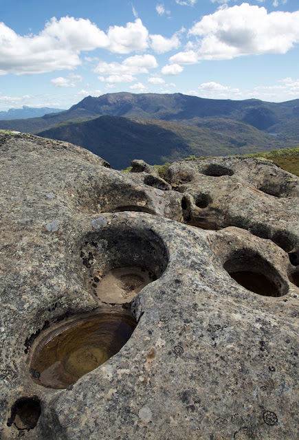
[Erosion features in the sandstone/conglomerate band] 
While Tim and Georgianna don’t leave a trail of breadcrumbs, they do leave a little reward for us at Gingerbread Hut. Yes, more gingernut snaps! Reenergised we toddle – and sweat – our way to the summit again, and find it no less awesome than yesterday. Perhaps the weather is even clearer, and the views more stupendous. Could anyone ever tire of this?

Yesterday when we crossed the band of sandstone/conglomerate rock, we had paused beside the track at a particular rock we dubbed “The Font”. A large slab of sedimentary rock, it had a natural hand-basin-sized hollow in it. This was filled with delightfully cool water, and we’d taken turns to splash our faces. We’d talked about having a baptism in the wilderness, even if it was more of an Anglican style baptism than anything John the Baptist would have conducted.


[Jim prepares for a wash in The Font]
Today, as we divert off the track to more fully investigate the rock band, we discover many more “fonts” eroded into the softer rock. Some of them are nearly large enough for a full-immersion style baptism, and we do consider having an “unclad” dip. But somehow the idea of washing our sweaty sins into this beautifully wild water deters us. Instead we mosey around these fascinating formations, taking in their homely strangeness. In places there are substantial overhangs, well-suited to an emergency bivouac. And perhaps, I wonder, Aboriginal camping.


[At a rock shelter looking towards the King William Range] 
It’s about here that the 21st century rudely interjects. I’ve been experimenting with a GPS tracking app on my iPhone. It uses the phone’s GPS capability to track your walk, with the added “benefit” of a voice telling you how far you’ve gone, and at what pace, every kilometre. Lynne and I had used the app in our local bush, and we nicknamed the (American female) voice Barb, reckoning she had a sharpish, slightly naggy tone.

So I’m experimenting with Barb in the wilds for the first time, carrying my phone on my hip-belt. She’s voiced our progress from the top of Rufus for the first little while. But as we wander around the weird rock formations, I suddenly notice the lack of nagging. I feel my hip belt, and there’s no phone! I back-track for nearly an hour, try to walk all over our wildly meandering route around the rocks, but there’s no sign of the phone.

It’s strange enough to be in the wilderness, lamenting the absence of such an intrusive device. It’s stranger still to find yourself calling Tim and George on Jim’s phone, asking them to keep their eyes open on their way back from Hugel. Not very helpfully I tell them it's somewhere between the top of Rufus and the sandstone/conglomerate band. 

On our way back I’m castigating myself – with some encouragement from Jim – for being so careless. But I decide I don’t want this walk to be brought low for me by this (expensive) incident. Instead Jim and I lighten up a bit, imagining Barb out in the wilds, still nagging, but with no-one listening.

“Time: 3 hours, 17 minutes. Distance: Still only 2.3 kilOMetres. Pace: too darned slow! Hey Pete … where are you? Are you listening??”

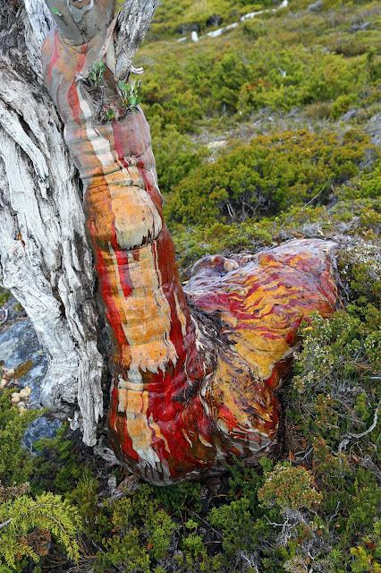
Somehow the thought of Barb crying in the wilderness lifts my mood. So too does our sighting of a brilliantly-hued snow gum beside the track.


[A Tasmanian snowgum (Eucalyptus coccifera) ablaze with colour] 
By way of a postscript, I have to report there’s no happy ending for Barb. Tim and George, semi-triumphant from getting at least part of the way up Hugel, aren’t able to locate the phone. So I return home phoneless. A few weeks later a friend walking the same way also searches in vain. It seems Barb is condemned to be a voice crying in the wilderness for evermore: or at least until the battery runs out. Just don’t tell her I’ve now got a replacement phone.