Sunday 30 March 2014

Frenchmans Cap 2: Fires on the Mountain

If progress towards Frenchmans Cap is measured in altitude gain, the efforts of the first day’s walk haven’t got us very far. We have left the highway at maybe 385m above sea level, and by the time we stagger into Lake Vera Hut, nearly 7 hours later, we’re only at about 552m.

We’re not inclined to do the maths just then, but that means we still have 900 odd metres of up to do before we get to the 1446m summit. For now the hut is enough. Despite our fatigue, we can’t help noticing how “kempt” it looks; bright, painted, swept and cheery. We recognise the hand of former ranger Terry Reid, who has acted as a part-time track ranger here since his retirement. Little bags with fire lighters, freshly-chopped kindling, a full bin of coal briquettes, spray surface cleaner and cloths, candles in holders, and a wonderfully informative log book: these little things add to the feeling that we’ve come to a place that is cared for – and that we’re welcome to.


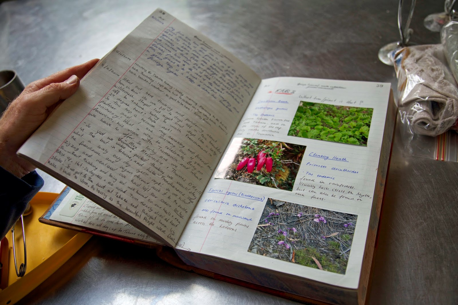
[The lovingly kept log book, Lake Vera Hut] 
The feeling carries on to the welcome from the walkers already in the hut. Rather than the grudging grimaces and reluctant gear shifting that can greet you when you enter a hut, the incumbents smile, welcome us, and show us which sleeping platforms are free. Along with the warmth from the fire, it sets the tone for a night of good – and surprisingly deep – conversation with some of our hut-kin.

Some of our conversation is even about bushwalking, from which we learn of the summit disappointments of those soon to head out from Lake Vera. Weather and bodily struggles have both played a part here, underlining to us that the major challenges of the walk are still ahead of us.

Still, the only way to climb 900m is one-step-at-a-time. It’s helped by the fact that many of the steps beside and above Lake Vera are through some of the most beautiful – if steep – rainforest anywhere in Tasmania. Some of those steps are literally made from the rainforest. Several fallen trunks have been turned into ladders, with notches cut out to fit walkers’ feet. A few muddy sections even have Huon pine rounds in them, an extraordinary extravagance if you consider only the “city” price of that wood.


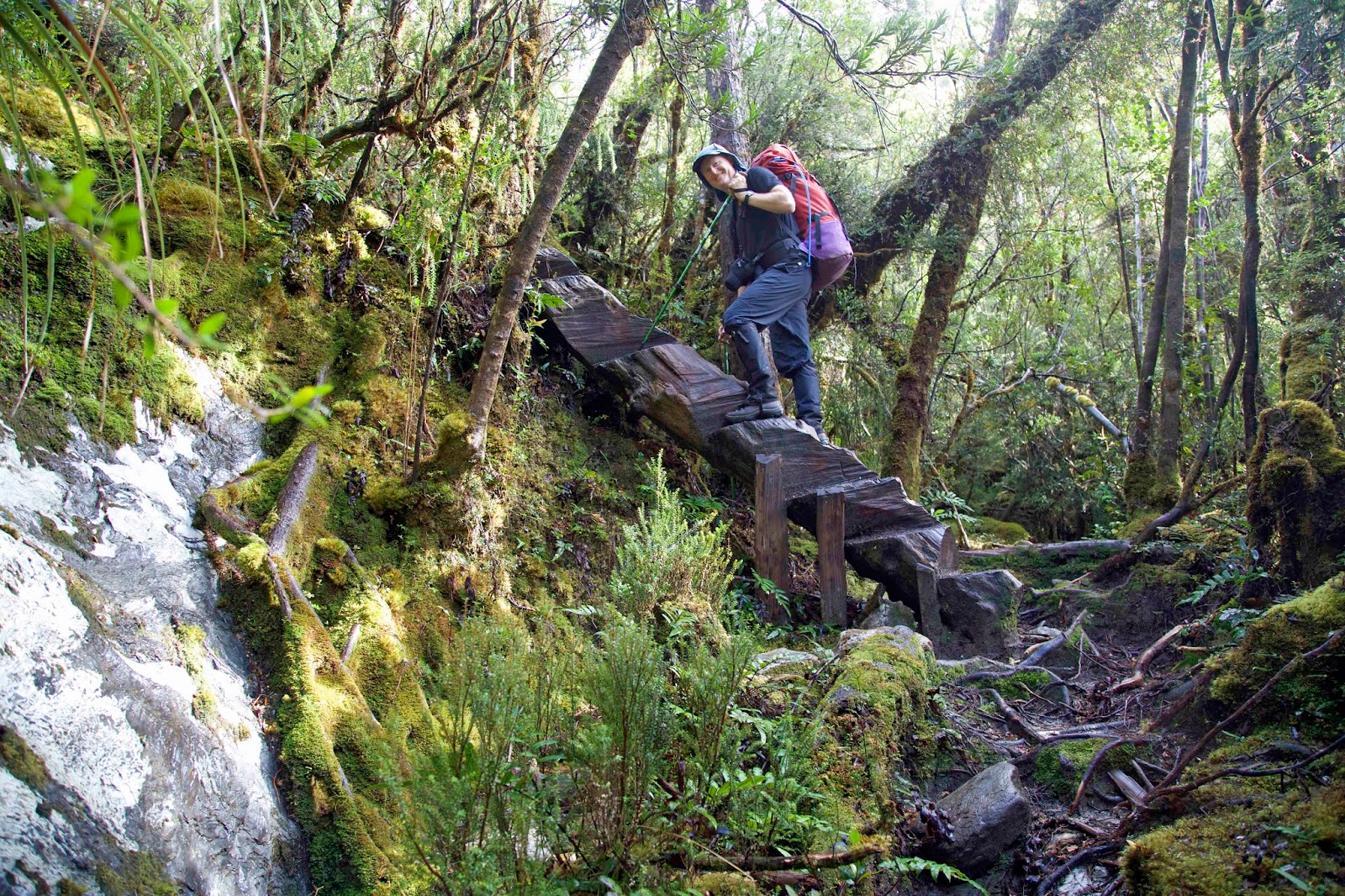
[Tim ascends one of the "log ladders" above Lake Vera] 
Tree-ring dating of Huon pine around Lake Vera shows that some began life here nearly 2 000 years ago. The same dendrochronolgy reveals some of the climate and fire history in the region, with significant fire events few and far between. This relative stability has encouraged the growth of complex, implicate rainforest with superb examples of high altitude King Billy and Huon pines alongside myrtle, sassafras, pandani, ferns, flowering heath and a wealth of fungi. The forest has a still and timeless beauty, dulling our desire to keep sweating our way up to Barron Pass. Or perhaps you could put that down to fatigue and a full pack.


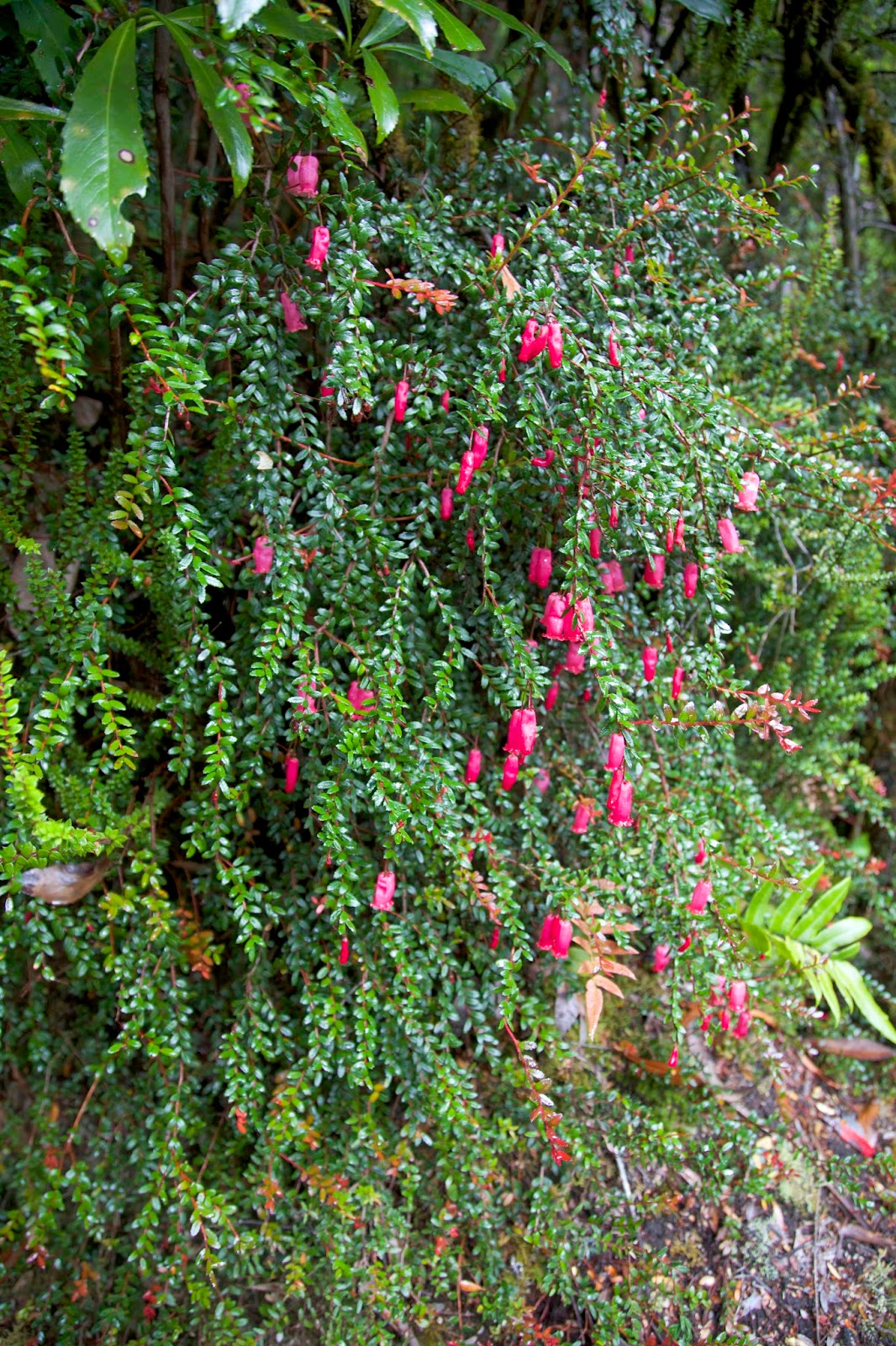
[Climbing Heath (Prionotes cerinthoides) in flower] 
It’s only as we finally break out at Barron Pass that we start to see what happens when fire does burn through this mountainous country. A fire lit by linesmen near the Lyell Highway in 1966 burned up through this area, devastating groves of King Billy pine, incinerating the Lake Tahune Hut, charring a vast area around Frenchmans Cap and beyond.

From Barron Pass through Artichoke Valley and on to Lake Tahune we see hundreds of stags of burned King Billy pines. For a tree with a limited range and a seven-year-long reproductive cycle, this was a catastrophic blaze. While the pines won’t return to their former glory in our lifetime – and possibly never will – it is encouraging to see some young King Billys along the track.


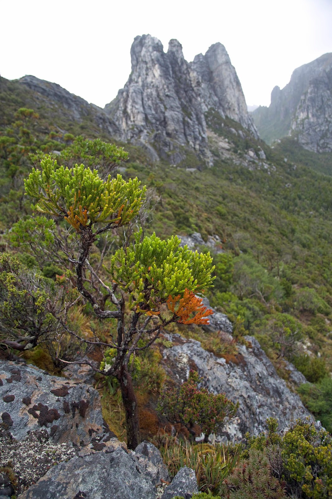
[A King Billy pine sapling beneath Nicoles Needle] 
While we’re contemplating fires in the mountains, it is raining, of course. We shelter for lunch in a very welcome cave beneath the quartzite spire of Nicoles Needle, then squelch our way across and down to Lake Tahune. The hut there was rebuilt five years after the 1966 fire. It is smaller hut than Lake Vera’s, and more humble, ugly even. It was prefabricated off-site, flown in by helicopter in two parts and positioned on Huon pine foundations. Poor ventilation, along with the frequently cold, moist air and often soggy bushwalkers, make it inclined to mould.


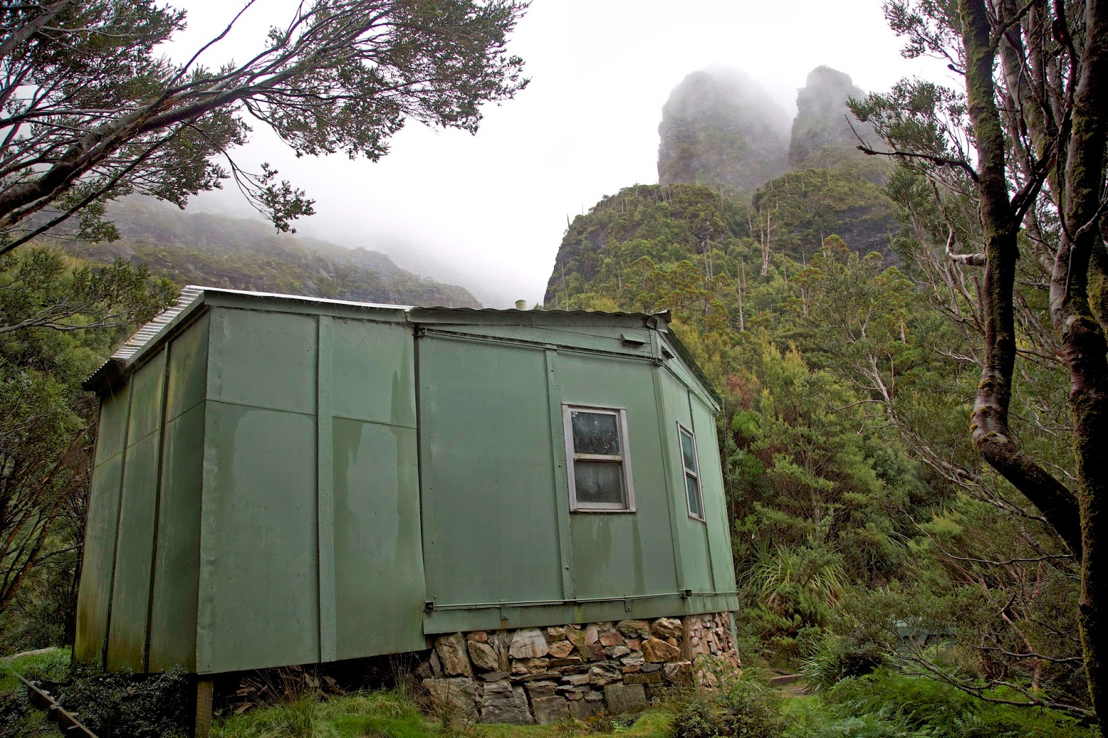
[A humble hut in a majestic setting: Tahune Hut] 
But it is in a spectacular setting, perched on a small forested shoulder beside the lake, with the sheer cliffs, rocky knuckles and steep passes of Frenchmans Cap directly above. In the weather that prevails we only see hints of this, ‘though later we will appreciate it more fully. In the meantime we appreciate the warmth – ironic given the fire history – of the hut’s little coal stove. We will soon be warm and dry and ready for tomorrow. That’s planned to be our summit day.


Sunday 23 March 2014

Frenchmans Cap 1: Echoes of the Past

Memory is a distant and shattered mirror, reflecting only a fragmentary, distorted version of the past.


[A distant view of Frenchmans Cap (right) from the new track]
Which has me wondering, on the eve of my second trip to Frenchmans Cap: was that first Frenchmans trip really as bad as memory has it? At the time, early January 1983, I wrote effusively to friends of our arrival at the summit.

We climbed out of a cool, cloud-filled valley only to be greeted by still and balmy conditions, and an ethereal glow from the thin sun on thick snow. It was a tremendous wilderness experience … made all the keener by the knowledge of the battle still going on below us, over the Franklin River.


[Crossing the Franklin River near the start of the track] 
I also noted that then Opposition Leader, Bill Hayden, had landed on the same summit by helicopter two days later. I added “half his luck to avoid 27km of Tasmania’s hardest walking!

The letter sets a little of the historical context. But that fragment about “Tasmania’s hardest walking” is more a reflection of my trip memories than a defensible fact. I had started under-prepared and flabby following a big Christmas. A couple of kilometres into the walk a member of the group had realised he’d forgotten some vital piece of equipment, and I’d volunteered to escort him back to collect it. “We’ll catch you up” I’d assured the rest.

That set the pattern: walk hard to catch up; stop for a much-needed rest; have the rest of the group immediately leave. You don’t want to meet the Loddon Plains in a state of exhaustion. Very accurately called “The Sodden Loddons”, this long section of flat, boggy track runs from the Loddon River more than 6km up Philps Lead towards the first hut.


[Tim and Nick at the start of the Loddon Plains] 
Its mud is as unavoidable as its depth is unpredictable. I recall plunging several times into thigh-deep bogs, heaving myself out of the boot-sucking mud only with great effort. Such exertions already had me staggering, but when I managed to find a chest-deep hole, it was too much. I just lay there, imprisoned in the chocolate brown ooze, as others gathered around to “help” or just to gawk. One “helper” reckoned they should start the “Loddon-Below-Peter-Grant” hydro-electric scheme right there.

But all that was more than 31 years ago. Now it’s March 2014, and I’m back to lay the ghosts of that walk to rest. I’ve heard, for starters, that “The Sodden Loddons” are no more. In a remarkable display of philanthropy, business man and keen bushwalker Dick Smith has donated $1 million over 10 years towards the upgrading of the track. The only proviso is that the Tasmanian Government has to come up with half that again, in total a $1.5 million makeover!


[Some raised boardwalk bridges a section of boggy track in the Loddon Plains] 

Six years into the Frenchmans Cap Track program, the biggest and best improvement is a long section of new track that bypasses the Loddon Plains. But after crossing the Loddon River, Tim, Nick and I are still on old boggy track, and we’re beginning to wonder when the new will begin. We then meet two trackworkers who tell us it’s just a couple of hundred metres ahead.

While it’s no magic carpet ride – you still have to actually walk it! – the new track does make a big difference. It meanders and sidles its way up towards the steep end of Philps Lead, but always at a moderate incline. The trackies have used a mini excavator, a motorised wheel barrow and a lot of sweat to create a track that will soon sit gently within the landscape.

Much of the track itself is raised and markedly convex, with drainage ditches on either side to minimise erosion in this high rainfall area. Nick tells us it’s a track technique that’s been working well since Roman times. Nonetheless we’re still surprised to see tread marks from the trackies’ “chariot” – the motorised barrow they use to deliver the locally-derived quartzite gravel that makes up the durable track surface.


[Tim checks out a new section of the track]  

For me the sweetest part of our hour or so on the new track is its lack of bog. Gone is that all-consuming effort to negotiate – and inevitably fall into – the wretched mud. Having a secure surface allows time for thinking, and time for talking. Time to consider, for instance, whether it’s always a good thing to put up with the mud that’s thrown our way.

30 years before his current track philanthropy, Dick Smith had stood up against the Gordon-below-Franklin hydro-electric scheme. He’d used his helicopter to drop radio equipment to protesters hidden in bush camps near the proposed dam site.

Today’s mud and murk can be the literal kind, and we can throw money and effort towards its defeat. But it can come in other forms too, the kinds that want to dam rivers or fell forests or un-declare World Heritage status. There are some fights that must continue. The still-wild Franklin River that borders our walk on three sides reminds us of that.


Sunday 2 March 2014

The Urban Platypus

The world is astonishing every day. We, on the other hand, are seldom ready to be astonished.

Most weekday mornings I walk down a track beside the Hobart Rivulet on my way to work. I like to think I am observant. I feel the cooler air that drains off the mountain, down our narrow valley. I notice the variations in the water flow: sometimes a racing torrent, sometimes an ambling companion. I discern the changes in the weather, the seasons, the flowerings and fallings.

Yet this is my daily exercise, and I am on the way to work. So I do not dawdle. Most times I am listening to my iPod: sometimes music, sometimes a podcast. It is good brain fodder, but a distraction nonetheless. There’s a lot I must be missing.


[Hobart Rivulet flows from a cloud-shrouded kunanyi/Mt Wellington] 

One bright Saturday morning, I am taking my time. There's no hurry to get anywhere, I'm not counting this walk as exercise. Today I am really looking because … well, is it because I care to really look? Or is it because I have taken my camera, so I can take some photographs? On this occasion the two merge, and I am twice surprised – greatly surprised – by what I see as I walk.

First up is a tiger snake, the palest I have ever seen. It has an unusual light green hue, and a burnished blush amidships. There are clear cream coloured “stripes” hooping up to a back that never darkens beyond business-suit-grey. It’s the stripes that gave these snakes their name, although many – perhaps most – are not noticeably striped.

This one is a decent size, at least a metre and half long, and it’s moving quickly. I’ve been creeping along the rivulet bank looking for photo angles and must have startled it. That surprise is mutual, yet although the snake is only a couple of metres away, and heading in my direction, my desire to photograph it is stronger than any thought of retreat. The reptile makes the “photo or flight” debate academic. It finds a hollow in the stream-side rubble so quickly that my camera doesn’t even make it to eye level.


[A bright autumn morning by the Rivulet] 
I tell Lynne, who is up at track level, and she suggests, rather strongly, that I join her there NOW. She has been startled by a snake once before in this vicinity, while cycling down the multi-use track. She tells me that “her” snake was a decidedly darker individual than the one I have described. Given the ample bush and fresh water along the rivulet, it shouldn’t surprise us that snakes would favour such a place. As with so much of our wildlife, we see far less than is actually there.

As though to prove that point, surprise number two happens just minutes up the track. A man and a woman are standing stream-side, engrossed in watching something. As we join them one quietly says “platypus”, pointing to what could well be an animated stone in the water. The remarkable creature is maintaining its position by swimming against the flow. As we watch it dabbles and ducks beneath the water, intent on finding the invertebrates that are its staple diet.


[Which is rock, which is platypus? Click on the image to expand.] 
How startling it must have been for the first Europeans to come across this monotreme. Surprising enough that a mammal should have a duck-like bill, webbed feet, a beaver-like tail, a venomous spur; how much more surprising when they discovered that it also laid eggs and yet suckled its young? It broke so many “rules” of natural history, that a sample sent to England was at first dismissed as a hoax. Scientists pored over its ill-preserved body looking for the join marks.


[A full-grown platypus, around 50cm from bill-tip to tail]
We stare, photograph and ogle for fully twenty minutes more, hardly less engrossed than any early explorer, or than the first time we saw a platypus. Here, only a couple of kilometres from the centre of Hobart, is a phenomenon of the natural world, an evolutionary rarity, insouciantly going about its business. Astonishingly it’s probably here or hereabouts every time I walk by; every time any amazing creature walks, jogs, rides, flies, hops or slithers by.