Thursday 30 December 2021

Walking the February Plains 3: Smurfing

If yesterday’s discoveries were unplanned, today’s will be deliberate - as long as we’re successful. From the cattle droving days of the mid 19th century, we’re skipping forward more than a century to the final days of the marsupial skin trade. And we’re looking for what’s probably the final hut Basil Steers built. He is often considered the last of the high country snarers in Tasmania. 


The hut we’re hunting was built relatively recently, during our own bushwalking days, in 1985. It’s sometimes known as ‘Basil Steers No. 3’, but is universally nick-named ‘Smurf Hut’. Its construction was partly a protest against the government’s 1984 ban on snaring as a method of taking animals. Given that provenance, Basil built the hut in a hard-to-find location, towards one edge of the Februaries. (Honouring that intention, I will not reveal its exact location here.)


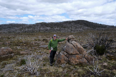
[Tim points the way, with Overland Track mountains ahead]
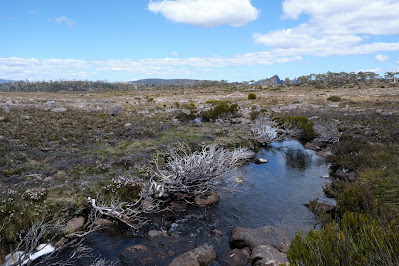
We set off quite early. The sky is predominantly blue, and the day promises to be warm. We by-pass Lake How, heading more or less south towards another lake. I naively assume it’s Lake Steers, which isn’t too far from our destination. It’s looking like a cruisy day. But not for the last time today Tim has to disabuse me of my belief. He points to some far-distant wooded hills, and tells me we’re headed towards them. We by-pass the unnamed lake, but still have to traverse some boggy ground getting across February Creek and its shallow valley.


[February Creek, with Mt Pillinger on the horizon]

Bit by bit we close in on those distant hills. Naggingly persistent feet manage this feat surprisingly well, although often at a cost. For an hour or more we’re high-stepping over knee high grasses and sedges. It’s not difficult walking, but it’s wearing. I’m encouraged when I finally see on Tim’s device that we’re closing in on the red dot marking the hut’s location. All the way I’ve been reassured by the fact that Tim has been to Smurf Hut before – hence the red dot. 


What I don’t realise until we enter some gnarly scrub is that Tim has never come to the hut from the northern Februaries. Rather he’s previously approached it from the Arm River/Wurragarra Creek direction. When you’re in bauera, tea tree and scoparia scrub, being told you’re “maybe 200m from the hut” isn’t as comforting as it may sound. After some sweat-inducing wading through said scrub, Tim concedes that we are too far west. We need to back-track. However we’re unable to stomach a complete retreat, so we choose a “tactical withdrawal", going diagonally uphill. 


We finally come out of the scrub into a pencil pine forest. This is promising, as Basil Steers and many other trappers/snarers preferred to use pines like these for building huts. Eventually we descend into the dim green of a myrtle rainforest, an even better sign, as Tim’s memory is that Smurf Hut is hidden deep in such a forest. And so it proves, as we eventually clamber down a small cliff, scramble over a series of mossy logs, and find the humble timber hut.


[Smurf Hut, with Tim outside]

Its name has always piqued my curiosity, but as we stoop to enter the hut, it explains itself. Everything about the hut is diminutive: the doorway; the size of the logs stored in the entryway; the height of the ceiling; the three wee bunks. It would be perfect for smurfs*. Indeed Tim and I agree it would be ideal for our friend Jim. Not only does he love a hut, especially one with a fire, but he is also – how shall we put this – a vertically-challenged man. The four foot long bunks would be perfect for him.
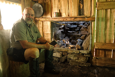


[Tim inside the diminutive hut]

We lunch outside the hut, soothed after our exertions by the cool quiet of the forest. After lunch I wander around the hut’s exterior. According to the late historian, Simon Cubit, the hut was never used as a skin shed, and certainly the walls show none of the signs of skins having been nailed there for drying or tanning.


We’ve learned lessons from our outward journey, and set off for our home lake via a less scrubby route. Although it’s still a long haul, all of it off-track, I’m pleasantly surprised to get back by mid-afternoon. While Tim soaks his hot feet in the lake I just sit back and enjoy being becalmed. Had we actually been sailing, it would have been a quiet afternoon. 
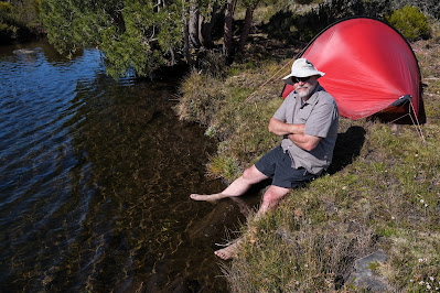


[Tim cools his feet]

There’s just the occasional puff of wind, and the lake is still enough to reveal one further secret. On the far side we can see the tell-tale ripples of a platypus at work. Occasionally it surfaces, bill, nose and eyes briefly visible before it dives again. I am in awe of these amazing creatures, not least because they’re one of only two egg laying mammals in the world (along with echidnas). I’m also astonished how they’ve managed to occupy this small lake that’s far distant from any other reliable body of water. I once watched a platypus toddle over land, and concluded it was unlikely to set any land speed records. Yet here they are, as they are in so many isolated lakes, tarns and creeks in Tasmania.


[A platypus walking overland]

After dinner I dig out some of my writing and read it aloud to Tim. On this walk, and earlier by phone, we’d been discussing some of my lock-down work about ‘the spirit of bushwalking’. It’s good to read it, albeit to an audience of one. It’s even better to discuss some of the knotty issues with someone who shares my perspective on walking and spirituality. Tim offers some helpful suggestions, and we toss around ideas, agreeing that there will be on-going discussions. I feel encouraged to keep working on it. Being detached from the everyday seems yet again to clear the mind.


Gradually the blue day morphs into a dark jewel of an evening, and our honest day’s walk helps sleep to come swiftly. When the light of our final day leaks into our campsite, it reveals a mirror-flat lake, enticing us out for an early start. We have one more item on our agenda: to pick up the trail of cairns from day 2, and see if we can follow the old February Plains Stock Route out.


[It's perfectly calm on our departure day]

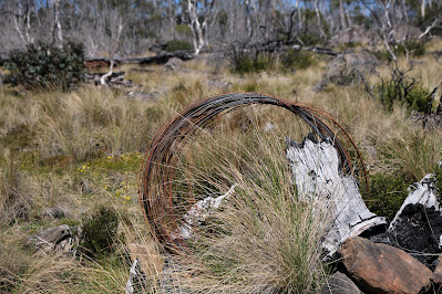
After all our years walking together, I should be aware that Tim’s journeys of discovery are rarely short-cuts. But as I’ve also been bitten by the exploration bug, the two of us happily fan out and scan for cairns. We walk far further west than we would otherwise need to, but are rewarded by the discovery of a series of cairns heading north. We follow these to Sardine Creek, near which we find some remnants of droving days. We feel sure that we have indeed been on the old February Plains Stock Route. 
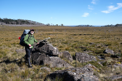


[Another cairn on the February Plains Stock Route]


[Old fencing wire, possibly from the cattle droving days]
But now it’s time to leave off being explorers and head out for a substantial – meaning not dehydrated – lunchtime meal. We cut down valley to pick up the old (locked) road that comes down the west side of the Februaries, close to Basil Steers Huts 1 and 2. We’ve been off track for nearly four days, so it’s strange to be moving fast on a solid surface. By the time we get back to the car, our feet are hot. But soon we’re driving off, and Tim announces a supreme idea. When he gets phone reception, he pulls over to ring his wife Merran. Without him even prompting, she graciously offers to make home-made hamburgers back at their place. Any aches and pains are so quickly eclipsed, that Tim and I do a happy little smurf dance before driving home. 


[A Smurf-blue sky bids us farewell]

For those who don’t know, smurfs are fictional creatures from the mind of Belgian comic writer “Peyo”. Small, blue and human-like, they live in mushroom-shaped houses in the forest. 

Thursday 16 December 2021

Walking the February Plains 2: Discovery

We’re lulled to sleep by a frog symphony. Urged on by their own inscrutable drives, they variously bleat, creak and croak through the night to an audience that wouldn’t normally include us. But we’re here, and what a privilege it is to have these calls dampen the din of our normal lives.


The morning breaks fine, with a cloud cover that harbours no threats. We have a slow brew and breakfast, chatting easily about many things before eventually turning to the topic of “where to now?” South is the general answer, with maybe a visit to Lake How and a wander to a high point a little west of there.


Tim eyes the peaks of the Overland Track

We take a meandering route to the lake, heading first to “the grandstand”. We’ve visited this high point before, and been stunned by the views. Again it doesn’t disappoint. We can clearly see almost every mountain of the Overland Track, from Cradle to Olympus. To the south-east are the high points of the Walls of Jerusalem, and north and east many more mountains, including Tim’s home peak of Mount Roland.


Reflections in a pool beside Lake How

Within an hour we’re standing by the shallow shores of Lake How. As pleasant as it is, we’re glad we didn’t tried to camp here. It’s a shallow scoop in a soggy, grassy plain, unprotected by bush or trees. We have a scroggin break and discuss our onward route. I’m pretty much in Tim’s hands, having not been this far before. We decide to climb a nearby hill and the ridge beyond it, to reach the probable high point of the Februaries, to the west of the lake.


Towards the Overland Track from the Februaries' high point

When we get there we again find exhilarating views. The deep valley of the Forth River lies between us and the Overland Track. Our equivalent latitude is well south of Barn Bluff, which we can see clearly. We stop for a very early lunch, and reminisce about walks we’ve done in these nearby mountains. For Tim it’s a significant anniversary: three years since a cardiac arrest on the side of Mount Roland almost ended his life. As we look at Barn Bluff we recall him having, in hindsight, what was probably a warning episode. When we were climbing the steep bluff, Tim was straggling behind when he would normally be leading. At the time he put it down to having given blood the day before we left. Now, by-pass and other surgery behind him, Tim is back to his best, and I’m grateful to be the one straggling behind.


We decide today will be a short day, and amble downslope, thinking we’ll loop back to our home lake for an early finish. But as we cross the shallow valley above Lake How, we make an odd discovery. On the valley flanks, on no obvious route, is a large rock cairn. We puzzle over it, wondering if it’s random, or linked to others. As we walk out of the valley we find another and then, a little further on, two more.


I’ve thought for some time about Frédéric Gros’ theory: that walking through such landscapes detaches us from daily trivia. I’ve certainly experienced the truth of that, but I’ve also pondered what happens to us after we’re detached.  Gros hints at us then becoming attached to that which matters. We’ve experienced some of that at our lakeside camp, and elsewhere on this walk. But I think the freed up mind is also now open to uncovering – or discovering – things which have been hidden from us by our cluttered minds.


One of the probable Stock Route cairns
So here we are, uncluttered by the thought of having to follow a track – there are virtually no walking tracks in the Februaries – and we discover a track! Actually it’s a route, as there’s no clear ground sign of people or animals walking this way. But Tim’s straight onto a theory. We may have discovered an old stock route: perhaps the February Plains Stock Route. If we’re right this route, pioneered by the Field family, dates from the mid 1800s. It was used to drive cattle from the Borradaile Plain through the February Plains to the Pelion Plains. Tim thinks he has seen one or two of these cairns on a previous trip, but we are now finding a continuous series of them.


Tim logs another possible cairn

We dutifully stop at each one, and Tim enters their GPS coordinates into his device. We photograph some too, noting that they’re far less elaborate, and less covered with lichen, than the cairns we followed on Ritters Track, east of the Walls of Jerusalem, last year. You can read more here: Ritters Track


This kind of discovery becomes quite addictive, and we describe a wider arc than we otherwise might have as we walk on to “just one more” cairn. Eventually we cut back to our home lake, but with the idea that we may try to resume the cairn search on our last day. However when we get back to our tents, Tim’s explorer blood is still bubbling. Given it seems to be a day of discovery, he’s all for trying to find signs of another 19th century track, that of E.G. Innes. This is thought to be on the eastern edge of the Februaries, perhaps a few hundred metres from our lake. By now I’ve taken my boots off, so I only follow part of the way, and soon bow out to photograph the nearby flora. Given their subtle beauty, that will be discovery enough for me. 


Rubus gunnianus (Tasmanian alpine raspberry)

Tuesday 14 December 2021

Walking the February Plains 1: Detachment

Being in the presence of what absolutely endures detaches us from that ephemeral news for which we are usually agog.

         – Frédéric Gros (‘A Philosophy of Walking’)

Of all the reasons we hoist a pack and walk into the wild, getting detached from our usual lives is close to a universal. When the walking starts, so does the slow shedding of the skin of our bustle. Before this walk both Tim and I had been burdened in different ways. In Tim’s case some difficult issues in his work as a consultant wanted to slip into his pack. In my case the ups and downs of a writer’s life had me doubting the direction my work was going. It was time to detach! 


Where we'd rather be

So preoccupied have we been that it’s only at the last minute that we choose the February Plains as our destination. It’s not the glamour choice for walkers in search of lofty peaks. It not only lacks those, it’s also deficient in such other drawcards as lakes and forests. And over the years this sub-alpine upland, rarely higher than 1150m, has been grazed, mined, burned and otherwise given grief. Especially hard were the wildfires of 2016, which have left swathes of its slow-growing bush stark and grey, adding to its scarred and weather-worn visage. 


Ready for off!

For all that, we know the Februaries have a way of wheedling their way into your heart. So we’re smiling as we slip on our packs and set off into what is still, a sign soon reminds us, part of the Tasmanian Wilderness World Heritage Area. It’s my third trip here, while Tim has lost count of his many visits to what is almost part of his back yard. 


A lunch stop at Basil Steers #2

While the detachment has begun, I soon find it’s not possible to leave behind my relative lack of walking fitness. The amount of ascent is low, but I’m still puffing more than I should. I’m glad when we reach one of the snarer’s huts built by Basil Steers and family in 1974. We’ve been here before and, after signing the log book, we enjoy a leisurely lunch in its well cared-for vicinity. We marvel afresh at how fortunate the hut was to survive 2016’s fires. Its forest surrounds are still blackened. 

Wildflowers are one beneficiary of the fires. Shortly after leaving the hut we come across carpets of ground-hugging Hibbertia procumbens, their bright flowers extravagantly strewn across our way like precious confetti. There’s no actual track. We just wind our way around bogs and scrubbier sections, sometimes high-stepping over thicker bush. Once we’ve got our rhythm, we settle into stories of past trips here, including Tim’s encounter with a giant tiger snake that chased him off its territory. I spy one of the hills we climbed last trip, recalling who was with us and what we’d talked about. I express my relief that we’re not climbing it again today with a full pack. 


A carpet of Hibbertia in bloom

A couple of hours after lunch we reach a familiar though unnamed lake, its shore dotted with pencil pines. We’ve discussed the possibility of looking for a campsite further on. But picking up on my mood, Tim is happy to make this small lake our base. He and his family know it well enough to have given it their own name, Lake Nycteris, after a character in one of their favourite George MacDonald fairy tales. They haven’t camped here though, so we spend the next half hour circumnavigating the lake in search of the ideal campsite. 


A burned pencil pine beside the lake

The 2016 bushfire has come very close, burning part of a nearby myrtle beech forest, and taking out a couple of pencil pines in the sphagnum bog by the shore. In the end we find a site just large enough for my one-person tent and Tim’s tent/tarp set up. It’s by the lake shore, next to the outlet stream, and beside a small copse of pencil pines. It’s perfect, or nearly so. As soft as it makes us sound, it’s only when we’re sitting in our Helinox Chair Zero chairs with a hot brew in hand that we really feel settled. We’re in total agreement that these little camp chairs are worth their 500g in weight! 


Our set-up beside the lake

Settled perhaps, but not yet fully detached, we keep chatting about the work matters that have added weight to our packs. And we talk real estate, comparing local development issues that threaten to change the feel of our respective local areas. But eventually these matters slide into the background. 


The wider scene, with Clumner Bluff behind

Here, by this quiet lake, tucked under its forested hill, with views stretching down valley and across to a distant Clumner Bluff, with a hundred frogs calling from the water, a few shy wallabies eyeing us quietly, and a sky only scantily clouded, we find the other side of the equation. Now we’re beginning to attach ourselves to what truly matters. This is real real estate.