Showing posts with label Clumner Bluff. Show all posts

Wednesday, 4 January 2023

Wandering the Little Fisher 1: Hot and Bothered

I should know by now that when it comes to bushwalking in Tasmania, “meticulous planning” is an oxymoron. I could bore you with all the plans; the variations on plans; the emails; the reply emails – or lack of them – and the “okay, how’s this?” follow-up emails. But let’s just say that busy-ness, weather, Covid, and human frailty all had their mitts on this walk. And yet …


[Starting Off in 32 Degree Heat, Fisher Bluff behind]


On a late December afternoon four walkers step out of an air conditioned car to be mugged by the heat of an old forestry coupe. Ahead of us stands a wall of mountains, familiar mountains. Their names, Fisher Bluff, Clumner Bluff, Turrana Bluff, Mersey Crag all speak of their verticality. Thankfully our first afternoon isn’t going to involve too much climbing. And that’s just as well, as our thermometer tells us it’s 32 degrees C. That’s great for swimming, but brutal for bushwalking with a full pack.


While the mountains are familiar, this view of them is less so. We’re walking up the Little Fisher River, a deep valley carved out of the Great Western Tiers. Officially we’re walking into the Walls of Jerusalem National Park, though well east of the better known tracks and mountains.


Pack on and sweat rising, the familiar call of black currawongs lightens my hot and bothered mood. I’m thankful too for the shade of the old forestry track we’re taking towards the tiers. We pause for a drink and a rest, and Tim D and I remember driving up here long ago, when this track was still open to vehicles. The road has been blocked off for years. More recently some huge weather events have eroded it so badly that not even the boldest of four wheel drivers would consider trying it.


[Erosion and repairs on the Little Fisher Track]


Our plan A for the first day had been to climb out of the valley and find a camp somewhere on the plateau near Long Tarns. In a concession to the heat, our tardiness, and the forward forecast, we’ve come up with a much more modest ambition. The Little Fisher is generally steep sided, but Tim has heard there may be camping near the river a couple of hours upstream of the start. His source has also told him that there’s an old cattlemen’s hut site in the same vicinity. Tim is keen to find and investigate the site. Two birds with one stone sounds like good energy conservation in this heat.


Even so, by the time we leave the track and clomp our way through a soggy sphagnum-filled area in search of a campsite, I’m exhausted. Thankfully it doesn’t take long. At the edge of some rainforest, where two minor creeks feed into the river, we find a very pleasant site. It’s both shady and well-watered, and we’re surprised to find no evidence of previous camping. We drink deeply, rest for a moment, then suss out space for three tents: Tim and Merran’s, Ken’s, and mine. 


[Camping in the forest, by the water: Ahhh!!]


When we’re satisfied with our setup, we prepare to go in search of the hut site. Tim’s informant hasn’t set our expectations too high. This won’t even be a ruined hut, just the hint of where a rough hut once stood. A GPS dot on a device is one thing; finding a site in quite thick regrowth is another. We spread out, and call to each other when we see anything that might be part of a site. Suddenly anything linear looks like a foundation or a fallen bit of a timber wall. Half an hour into our search Tim finally finds something more definitive. He calls us over to see some artefacts, a few glass bottles, a rusting billy and plate, and a bit of chain. A little away from the site we find some celery-top pine stumps. The builders seem to have cut more than they used, as some pine logs are still lying unused, partly preserved by their rot-resistant resin. 
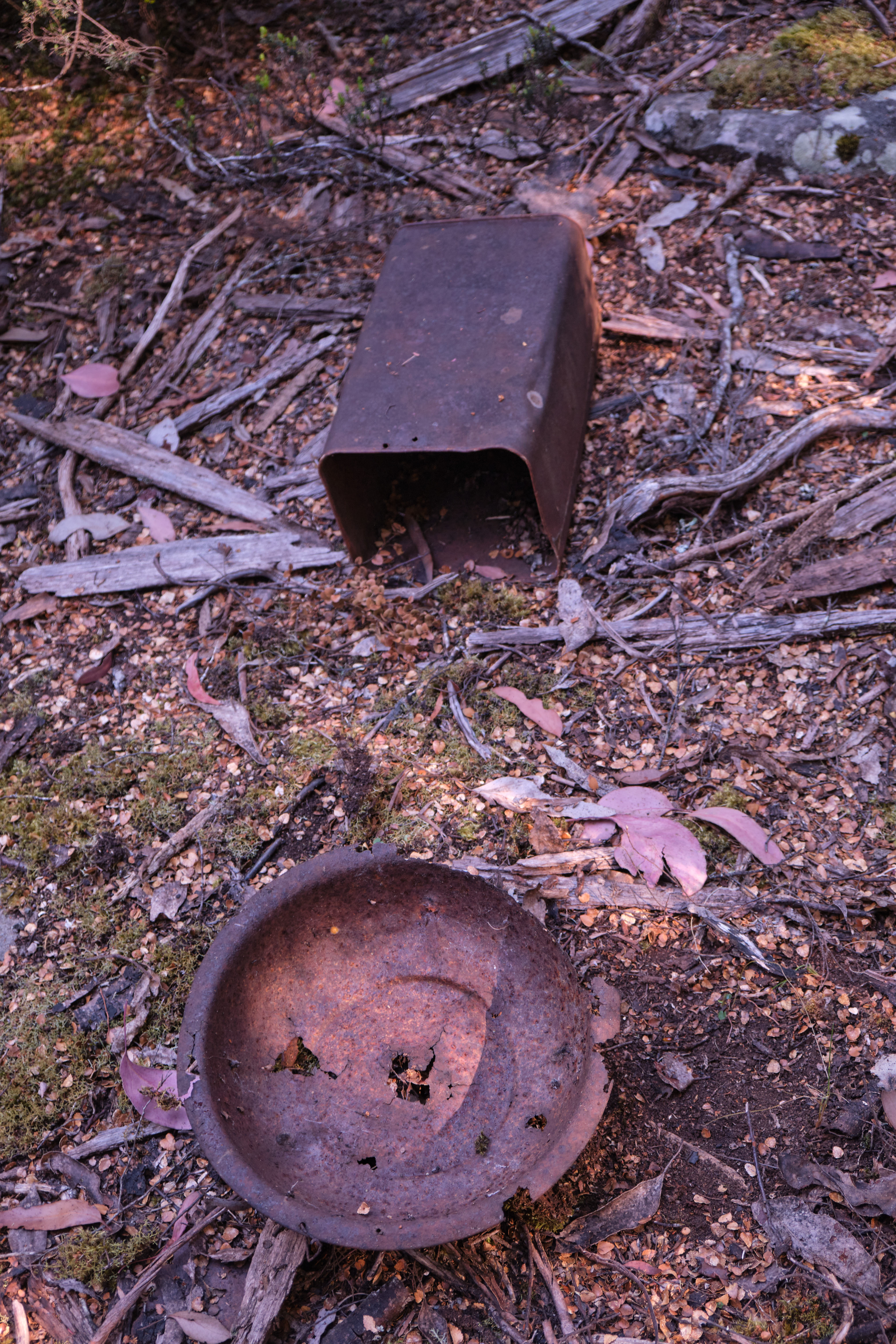


[Artefacts at the old hut site]


Without doing any formal analysis, we guess to site to be at least 100 years old. Certainly in the late 19th century the area was regularly visited by cattlemen, who drove their stock up to summer on the pastures at this and higher altitudes. Between loggers, trappers and drovers, the area was well known and used. Yet now the forest, well-watered in this high rainfall area, is taking over again.


[Ken and Tim at the hut site]


The hut site, sensibly, is elevated above the river valley. But as a large pool in the river is within about 100 metres of it, we detour that way on our return. The day is still very warm, and we’re sweat-soaked from our exertions. It would seem rude not to have a swim, so we do. 


[The Swimming Hole: You Can Keep Your Hat On.]


The water is VERY bracing, but still an almost perfect way to end our hot day. Only a good meal and conversation back at the camp could improve on that. It does.


[Merran and Tim: Happy Campers]

Tuesday, 14 December 2021

Walking the February Plains 1: Detachment

Being in the presence of what absolutely endures detaches us from that ephemeral news for which we are usually agog.

         – Frédéric Gros (‘A Philosophy of Walking’)

Of all the reasons we hoist a pack and walk into the wild, getting detached from our usual lives is close to a universal. When the walking starts, so does the slow shedding of the skin of our bustle. Before this walk both Tim and I had been burdened in different ways. In Tim’s case some difficult issues in his work as a consultant wanted to slip into his pack. In my case the ups and downs of a writer’s life had me doubting the direction my work was going. It was time to detach! 


Where we'd rather be

So preoccupied have we been that it’s only at the last minute that we choose the February Plains as our destination. It’s not the glamour choice for walkers in search of lofty peaks. It not only lacks those, it’s also deficient in such other drawcards as lakes and forests. And over the years this sub-alpine upland, rarely higher than 1150m, has been grazed, mined, burned and otherwise given grief. Especially hard were the wildfires of 2016, which have left swathes of its slow-growing bush stark and grey, adding to its scarred and weather-worn visage. 


Ready for off!

For all that, we know the Februaries have a way of wheedling their way into your heart. So we’re smiling as we slip on our packs and set off into what is still, a sign soon reminds us, part of the Tasmanian Wilderness World Heritage Area. It’s my third trip here, while Tim has lost count of his many visits to what is almost part of his back yard. 


A lunch stop at Basil Steers #2

While the detachment has begun, I soon find it’s not possible to leave behind my relative lack of walking fitness. The amount of ascent is low, but I’m still puffing more than I should. I’m glad when we reach one of the snarer’s huts built by Basil Steers and family in 1974. We’ve been here before and, after signing the log book, we enjoy a leisurely lunch in its well cared-for vicinity. We marvel afresh at how fortunate the hut was to survive 2016’s fires. Its forest surrounds are still blackened. 

Wildflowers are one beneficiary of the fires. Shortly after leaving the hut we come across carpets of ground-hugging Hibbertia procumbens, their bright flowers extravagantly strewn across our way like precious confetti. There’s no actual track. We just wind our way around bogs and scrubbier sections, sometimes high-stepping over thicker bush. Once we’ve got our rhythm, we settle into stories of past trips here, including Tim’s encounter with a giant tiger snake that chased him off its territory. I spy one of the hills we climbed last trip, recalling who was with us and what we’d talked about. I express my relief that we’re not climbing it again today with a full pack. 


A carpet of Hibbertia in bloom

A couple of hours after lunch we reach a familiar though unnamed lake, its shore dotted with pencil pines. We’ve discussed the possibility of looking for a campsite further on. But picking up on my mood, Tim is happy to make this small lake our base. He and his family know it well enough to have given it their own name, Lake Nycteris, after a character in one of their favourite George MacDonald fairy tales. They haven’t camped here though, so we spend the next half hour circumnavigating the lake in search of the ideal campsite. 


A burned pencil pine beside the lake

The 2016 bushfire has come very close, burning part of a nearby myrtle beech forest, and taking out a couple of pencil pines in the sphagnum bog by the shore. In the end we find a site just large enough for my one-person tent and Tim’s tent/tarp set up. It’s by the lake shore, next to the outlet stream, and beside a small copse of pencil pines. It’s perfect, or nearly so. As soft as it makes us sound, it’s only when we’re sitting in our Helinox Chair Zero chairs with a hot brew in hand that we really feel settled. We’re in total agreement that these little camp chairs are worth their 500g in weight! 


Our set-up beside the lake

Settled perhaps, but not yet fully detached, we keep chatting about the work matters that have added weight to our packs. And we talk real estate, comparing local development issues that threaten to change the feel of our respective local areas. But eventually these matters slide into the background. 


The wider scene, with Clumner Bluff behind

Here, by this quiet lake, tucked under its forested hill, with views stretching down valley and across to a distant Clumner Bluff, with a hundred frogs calling from the water, a few shy wallabies eyeing us quietly, and a sky only scantily clouded, we find the other side of the equation. Now we’re beginning to attach ourselves to what truly matters. This is real real estate.

Tuesday, 25 June 2019

The Secret Highlands 2: Broken and Ugly


In the chill of the morning, while some of us were pulling sleeping bag hoods around our ears, Libby was up getting the fire started. The night before we’d decided there was no urgency about getting going in the morning. That, at least, was my excuse for staying à bed. But the warm flicker of flames that lit the hut proved the ultimate in gentle alarm clocks. How we humans are drawn to the flames!


[Drawn to the Flames!] 
After brekky we were in Tim’s hands. He suggested we pack lunch and head south, towards the February Plains. We were keen to explore this undulating plateau, with its grandstand views over Cradle Mountain National Park to the west, and the Walls of Jerusalem National Park to the east. But there was still cloud about, and views might be better with the clearer weather that was forecast for tomorrow. Besides, Tim’s agenda for today had a touch of the train-spotter about it.

In 1895, E.G. Innes and team had surveyed and cut a potential rail route between Mole Creek in the north and Rosebery in the west. Although the railway line never eventuated, some parts of his cut route can still be seen, including on a section of the Overland Track west of the Pelion Plains.


[Across the plains, with fire aftermath around us] 
Innes’ official report spoke of the landscape near here as “broken, ugly country”. After reaching what he called the Mackenzie Plain – probably part the February Plains – he “turned again south …. (and) skirted the side of the hill at an easy grade, through a country covered with a dense growth of myrtle and pepper tree.”

Tim was keen to find evidence of Innes’ Track, especially where it “skirted the side of the hill”. Innes had presumably tried to take a line below and to the east of the highest country in order to avoid the worst of the weather that can lash this area.

So after walking south for a short while, we swung east and began to wander up a broad, open valley. The only thing remotely “broken” or “ugly” about it was the widespread fire damage from the Mersey Forest fires of summer 2016. There was stark burned forest on the valley fringes; burned scrub and buttongrass in the valley floor; even cracked and blackened rocks. The same fires had burned east around Lake Mackenzie and the Blue Peaks, and south-east through parts of the Mersey highlands. They were started by dry lightning, a phenomenon thought to be one of the local outcomes of climate change. I’ve written about these fires here http://www.naturescribe.com/2016/02/a-tasmanian-catastrophe.html

As we neared the edge of the upland, we began to get partial views east across the deep Mersey Valley towards Clumner Bluff and the Walls of Jerusalem. Tim had marked on his GPS that this was where we might find traces of Innes’ work. The fires had made our search both easier and harder: easier because we could see further, and walk more easily through the fire-cleared undergrowth; harder because many windfall trees blocked our way and obscured the kind of evidence we were searching for.


[Searching for Innes Track] 
After a couple of hours of off-track scrambling, we admitted defeat. We’d seen hints of cut lines, but nothing that was continuous and unambiguous. For our troubles we were sweaty and blackened, so we sought the compensations of lunch and a view on a high rocky knoll. We scored better. A large wedge-tailed eagle graced us with its presence as we ate. It perched for some time in a bare tree just above us, then took off, circling above for a final look. In its honour we dubbed our lunch hill “Eagle Rock”.


[A wedge-tailed eagle at "Eagle Rock"] 
We decided we’d return to the hut a different way, just for variety, but managed to collect even more scratches and black stripes from having to push through thick burned scrub. It had been two and a half years since the major fire here, yet there were only glimpses of good recovery. The cliché that all Australian bush was made to burn, and recovers well from burning, looked far from true up here in the sub-alpine zone.

Wildflowers were fairing best, taking advantage of the increased light, decreased competition, and a bed of ash for germination. Orange everlasting flowers (Xerochrysum subundulatum) particularly stood out against the blackened trees. Some of the eucalypts and other alpine trees showed only sparse and sporadic regeneration. Many trees stood stark and dead. But we were surprised at one point to find a clump of myrtle beech (Nothofagus cunninghamii) shooting from the base of their burned trunks. I’d heard they could survive light fire by sprouting from basal epicormic shoots, but this was the first time I’d seen it. Presumably the fire was less severe in the wet lee of the hill where we found them.


[Orange Everlasting flowers thriving after fire] 
Our via the cape return trip ended mid afternoon, in time for us to collect more firewood. It promised to be a cold night, so the fire would be very welcome. But alongside our anticipation of a good fire, we felt a strong sense of irony. We’d seen some of the dreadful havoc that fire could wreak in this alpine country. And we knew too that the various types of human-caused fire – whether through deliberate ignition, or anthropogenic climate change events like dry lightning – had burned out acres of beautiful flora up here, and especially large stands of superb pencil pine. It’s hard to shake the feeling that fire will continue to push some of these species to a brink that would be truly “broken” and “ugly”.