Sunday 29 December 2013

A Ben Lomond Traverse: Part 2

Ben Lomond is not a lush part of Tasmania. Too high for trees; too windy for soft-leaved foliage; too rocky and cold for deep soils, it feels underfed, gaunt, boney.


[The scoured shore of Lake Youl, Ben Lomond National Park] 
It is not a place for comfortable rest. Except perhaps on a rare, calm summer’s night, when a storm has passed and the wind-blown sediments cover the earth’s bones well enough for a tent to seem almost snug. On such a night the universe will wheel silently above, and you will think there is no finer place on earth.

Our calm night is followed by a fine day, perfect for exploring the south-western edge of the plateau. But we have a complication in the day’s plans. Our mate Tim has decided to join the group late, coming up via Stacks Bluff. “I’ll meet you before tea on Tuesday at Lake Youl. What could possibly go wrong?” We’ve heard that before: but we put that niggling doubt to the back of our minds and make for Grant Cirque.


[En route to Grant Cirque, Lake Youl behind] 
The nomenclature of the plateau reflects the English-speaking world’s fascination with the search for the source of the Nile River in the 1850s. So a modest stream rising near this end of Ben Lomond plateau is named the Nile River, and a number of features are named after Nile River explorers, including Speke Gorge, Baker Lake and Grant Cirque. Sphinx Bluff too has an obvious Egyptian link.

Our own imaginations are more fired up by what we’ve heard about Grant Cirque. Geologically-speaking Ben Lomond’s boulderfields, the result of millennia of ice action, are some of the most extensive in the southern hemisphere. We have experienced a little of that in getting to Lake Youl, and have more boulder hopping to do on our way to the plateau’s edge. But Grant Cirque is the result of ice action of a different kind.

Where all on the plateau has varied only quietly from the horizontal, here the vertical begins to shout. If it is a cirque, is has no classic bowl-shape. Rather it is a giant, sloping, shovel-shaped groove. It has been cleft at Speke Gorge where the upper Nile River has gouged a path to the Midlands.


[Grant Cirque at the south-western edge of Ben Lomond] 
 The beauty of the place is undeniable if austere. The bones of the earth are laid bare in a manner more reminiscent of the arid MacDonnell Ranges than well-watered Tasmania. It’s a reminder that harsh conditions for soil and plants can result from cold as well as heat. And that cruel conditions can result in deep beauty.

We enjoy a slow lunch on this bouldery edge, perched like eagles above the distant, straw-coloured Midlands. I work out that we’re probably sitting atop one of those “slices of bread” visible from the highway down there, with Speke Gorge one of the more visible gaps.

On our return to Lake Youl we take a wide arc south, hoping to intercept Tim on his way up from Stacks Bluff. There is no sign of him on any of the routes we’d expect a walker to try after gaining the plateau’s edge. What could possibly go wrong? We run our minds through a long list, and settle on “I left a little late” as the most likely in Tim’s case.

And so it proves. After dinner, with only hot drinks and chocolates to come, Tim yodels from a distant hill to announce his arrival. We’re glad to see him: and to give him a clip around the ear! He is three or more hours late (yes, he left a few hours later than planned). It’s been a long, steep climb, and he’s glad of a bit of help heating up dinner and some soup.

It seems cruel that the next morning he’ll have to pack up and join us on our return via Stacks Bluff. But he seems happy just to be here; happy enough to even have a sunset dip in the lake after his dinner; happy also to taunt us – and especially Jim – about the steep, exposed route we’ll be taking tomorrow.

But in the morning our first task, after we break camp, is to get to the summit of Stacks Bluff. I’ve been waiting to do that for three decades! For all the verticality surrounding it, the top of Stacks Bluff is relatively flat. Even the summit cairn is modestly low; a flattened scone rather than a wedding cake . All around us scoured and fissured lumps of dolerite and tough, dark green scrags of vegetation hint at the climatological and geological rigours of this place. But today all is calm, wide and handsome.


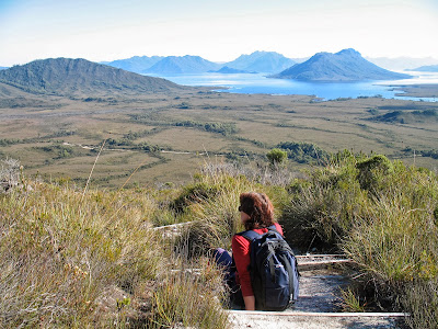
[A panorama from the summit of Stacks Bluff] 
We enjoy our summit moments, knowing that we’re in for a hairy, steep descent. We expect Tim to lead us straight to the downward track, but he manages to miss-place it for a few minutes. He scrabbles around for cairns, eventually pointing to a very unlikely looking chute, and calling us cheerily down. What follows is as steep and bouldery as any of Tasmania’s classic dolerite scree descents; harder than Ossa or Cradle. In a few spots, given our full packs, we choose to go down backwards, which affords us amazing views of the huge buttresses of rock through which we've descended.

It's a hot day and we move slowly, especially Jim, who is uncomfortable boulder-hopping on rocks this large and (occasionally) mobile. A short way down we start to see distant bushfire smoke, just as Tranquil Tarn comes into view. It is perched nest-like on the slope far below us. A classic hanging cirque, its bright green waters are rimmed by boulders and vegetation.


[Descending Stacks Bluff, with Tranquil Tarn below] 
Once we negotiate the seemingly endless boulder fields, the lure of the water takes a couple of us off track. It lives up to its name; calm and peaceful, although it's not a place that invites camping. The shore is very rocky, and there are no flat spots for a tent. We have a long drink and get back to the bouldery descent, which persists for a while yet.

Finally the slope lessens, trees start asserting themselves, and we come out onto the 4WD track that will lead us to our cars. We’re glad to stop walking at last; glad too to find the vehicles unmolested – there had been stories about Storeys!


Tuesday 24 December 2013

A Ben Lomond Traverse: Part 1

Travel Tasmania’s Midland Highway between Launceston and Hobart, and only fog – real or metaphorical – will stop you from noticing the Ben Lomond plateau. It vaults above the relatively flat northern midlands, a dolerite island more than 18 000 hectares in area, most of it over 1300m above sea level.

From the highway its southern edge, Stacks Bluff (1527m), looks like a giant loaf looming over the Fingal Valley, its enormous dolerite slices seemingly caught in a frozen topple. At its northern end the plateau tops out at Legges Tor, at 1572m Tasmania’s second highest point.


[Walking south across the Ben Lomond Plateau] 
The plateau is named after the Scottish Ben Lomond: Beinn Laomainn in Gaelic, (which translates as “Beacon Mountain”). It sits above the eastern shore of Loch Lomond, in the south of the Scottish Highlands. At 974m it is nearly 600m lower than its Tasmanian namesake. Scots do homesickness well, having also “found” Ben Lomonds in New Zealand, California and Trinidad.

During the 1980s I had seen plenty of the northern part of “our” Ben Lomond, as I scrambled around Legges Tor and the nearby crags, and snow-played on its ski slopes. I’d missed out on trips to Stacks Bluff, though I knew plenty who had been there. Curiously I knew no-one who had ever walked the length of the plateau, just a few skiers who had done the nearly 30km return run as a day trip.

I began to ponder what it would be like to walk through that high country for a couple of days. I’d walked and camped at altitude in Tasmania many times. But in my experience most of our country above 1400m is narrow, steep and peaky. You pick your way up and around boulder fields, through steep, scrubby creeks, over high, ruckled moors. But the Ben promised to be wide open and big-skied.

I wondered if it might be a little like the Central Plateau, although few sections of that are much above 1200m. And the extra altitude of Ben Lomond robs it of two of the Central Plateau’s features: trees and substantial lakes. I next thought about other large, flat-topped mountains in Tasmania, like Mt Massif on the Du Cane Range, and the Olympus Plateau above leeuwuleena/Lake St Clair. They certainly reach similar altitudes to the Ben, and are substantially above the tree-line. But next to Ben Lomond they are pygmy’s knuckles to a giant’s fist. Ten minutes walking would see you across Massif, and even the longest section of Olympus would take only a few hours. To traverse the Ben Lomond plateau would take near enough to two days of walking. It promised to be a high walk in a league of its own.

So to the research. I needed to consider where to start and finish, where to camp, and the state of walking tracks. The last was the easiest to answer. What walking tracks? Between the ski field and Stacks Bluff there was no regular track, just some ski poles at the start of a cross-country trail that was now rarely used. On the other hand there was no forest, and supposedly little scrub. It looked like being an open, off-track alpine ramble.

Transport was another “interesting” consideration. From the ski field road to the road beneath Stacks Bluff was about 130km by road, yet hardly 15km on foot. We decided on a car shuffle, with cars to be left near Storeys Creek, beneath Stacks Bluff, and at the Ben Lomond ski field. 

Is it ever quick and easy coordinating walkers from both ends of the state, meeting up, organising tents and food, doing a car shuffle, and finally getting to the actual start of the walk? When you also take a “long-cut” there (aka getting lost), it should be no surprise if you don’t get as far as planned on the first day.


[Scoparia in bloom: pretty, but best avoided 

In reality we didn’t get away until very late in the afternoon, in very hot late-January sunshine. We followed the ski poles for the first short while, but very soon we were sweating and huffing as we picked our way, on a rough compass setting, through low but surprisingly persistent scrub.

We were to skirt a little east of a straight line between the ski field and Stacks Bluff, roughly down the Meadow Vale. This was to help us avoid thicker scrub between Giblin Fells and the scarily-named Little Hell. Regardless one of our party was soon struggling with the heat and a lack of walking fitness. When he stumbled and fell, we thought it best to camp wherever we could find water and a flattish spot.

You know you’re staying somewhere original when there are no signs of humans even around a water source; when your tents sit on thick, springy vegetation; and when the local invertebrates are curious enough that they come right into your tent for a good look.

The next day started warm and still, and promised to grow hot. We checked the map, did our best to guess the least scrubby route, and set off towards Lake Youl. The plan was to camp there for a few days, explore the southern end of the plateau, then descend via Stacks Bluff.

You have to grant that scoparia, while best avoided, does offer compensations to its prisoners, at least at this time of year. After some close-up views of scoparia, and some artful dodging of more, we climbed up a small rise and there was the lake.


[Looking west across Lake Youl] 
Lake Youl is a large, shallow lake trending north-west to south-east. It’s shaped roughly like a funnel, which is apt given that the strong winds have concentrated wave action so heavily here that there are pebble dunes at the lake’s southern end. These extraordinary features rise more than a metre above the shore of the lake, providing the only hope of a sheltered campsite.

Having settled into the campsite before lunch, we spent the afternoon splashing about in the lake. I would have said swimming, but that would have required water deeper than the 20cm we found, even 100m from the “beach”.


[Clouds threaten a storm over our Lake Youl campsite] 

Late in the afternoon clouds piled up and blackened around us. Lightning, thunder and squally showers sent us to our tents for a time, but these cleared in time for dinner and another “swim”. The wind dropped away as well, undoubtedly a good thing given the evidence of its strength here in the form of wind-blown pebbles and rocks all around us.


[Lake Youl's sediment and dune system] 


Sunday 15 December 2013

Bach to the Future


[Johann Sebastian Bach, ca, 1745] 

Is this the future? I am sitting in Sydney’s airport having a desultory conversation with a young Australian of Indian descent. He’s on his way to visit family in Calcutta.

We speak of the usual things: travel, work, family. He lives in Sydney, and loves it for its shopping. But being temporarily out of work in the IT industry here, he’s off to work for his uncle back in India.

I ask him about Calcutta, and he describes a vibrant, busy city that’s "great for shopping". I quiz him about India’s wilder parts. He has been to the Himalayan foothills a couple of times. But he feels quite uncomfortable in the countryside (and here he gives a little shudder). He doesn’t care to be long away from the city’s bustle … and its shopping.

He asks about Tasmania. I tell him about its mountains, its beautiful wild places, its relaxed life-style. When he asks about its shopping scene, I have to disappoint him. “You wouldn’t come to Tasmania just for its shopping.” He nods, and turns to his smart phone for a facebook fix.

Have I struck an unusually shopping-obsessed, nature-phobic character? A few days in Sydney incline me to think him not atypical: that this may be the shape of the future. Retail therapy, device-addiction and a deep fascination with “stuff” are on show everywhere in Australia’s biggest city. They all point in the same direction: many of us prefer the worlds of our own creation to those of nature.

I disembark a ferry in Cockle Bay, near Darling Harbour. There is not the slightest chance that a cockle could live here any more. There is no bay, no natural shoreline, no rocky coast: in short no habitat for the life form that gave this place its name. All is tarred and tamed to the service of commerce.


[Looking over Cockle Bay and Darling Harbour, Sydney] 

A few days later I am back home, ruminating on my Sydney visit and listening to some J.S. Bach. I've heard that some 200 years ago, at about the same age as my young Indian Australian, Bach walked 260 miles (420 km) across Germany to hear and learn from the famous organist/composer Dietrich Buxtehude.

I suppose the young have always travelled for inspiration and the prospect of work. But which of us would have done it all on foot? And what have we lost in our ability to travel quickly and easily; to stay in touch instantly; to gather information in seconds rather than months or years?

We know little detail of the 20 year old Bach’s journey, so I can only conjecture. I see him with a staff in his hand, a satchel over his shoulder. He wonders about his life as he moves from village to town, from city to hamlet. His head is full of creative thoughts, ‘though he is still two years away from publishing his first musical work.

It is winter, cold and wet, and the young Bach can’t always find or afford dry shelter. He sees – and feels – the rain, fog, snow and sometimes sun. He watches the sky, sees the birds, the tracks of animals in the snow. Is that a wolf he hears?

Whatever else his journey encompassed, it gave Bach a real and constant exposure to the natural world (what he would have called God’s creation) as well as the social order. While Bach may have become a singularly extraordinary composer, his experience of travel – and of the natural world – was commonplace for his time. Is it any wonder that Bach, a devout Lutheran Christian, repeatedly – and brilliantly – invoked God’s creation in his subsequent compositions? 


[Awe inspiring tall trees in a Tasmania forest]
Were Bach to write a letter to the current generation, I am sure that faith would figure prominently. But I suspect the letter might also suggest that we get outside and experience creation a little more often; that it is no bad thing to be overawed by its wonders. I wonder would it be too much to ask him to also put his ideas in a facebook status update?

Sunday 24 November 2013

The Bishop and the Ballerina


[Looking over Darlington Bay, Maria Island]

The first time I got close to a bishop I was around 15 years old. Apart from his “funny hat”, I remember the meaty weight of his hands, as he laid them on my young head and intoned “Defend O Lord this thy child …”. Since then I’ve been on friendly terms with a couple of bishops. Yet until recently I had somehow avoided meeting one particularly solid Tasmanian example.
Bishop and Clerk is a mountain, or more accurately a cluster of dolerite spires, that rises 620m straight up from the Tasman Sea at the northern tip of Tasmania’s Maria Island. Its name derives from a supposed resemblance to a processing bishop and his attendant clerk. From Darlington it’s a sometimes cloud shrouded backdrop, picturesque and prominent but never intimidating. It has always struck me as an easy peak to reach. Perhaps that’s one reason for us never having met, despite my dozen or so trips to this beautiful national park. Perhaps it’s also that the island holds so many other wonders.

But sometimes the ducks line up. A long weekend; a break in the weather; a few other walkers who’d never been to the Bishop, saw a group of us wandering up towards the stony cleric.


[Looking towards Bishop and Clerk] 
 620m doesn’t sound much. After all most Tasmanian peaks worth aspiring to are double that height or more. But I should have remembered my previous experience with Mount Rugby, in Tassie’s south-west. It rises just 771m above sea level: but sea level is the crunch here. Most Tasmanian mountains are climbed from foothills that are already several hundred metres high. With Mt Rugby and, I should have realised, Bishop and Clerk, you start at sea level. You have to gain the whole of its height using leg power.


[Looking towards the Freycinet Peninsula from Maria Island] 
For much of the way Bishop and Clerk is actually a stroll, and a spectacular one at that. You amble along through open pasture, climbing gently. To the left of the track are the spectacular drop-offs of the Fossil Cliffs. To the north are distant views of the mountains of the Freycinet Peninsula. Ahead are the rocky pillars of Bishop and Clerk, oddly slow to come any closer.

The track steepens, the woodland thickens, and still no summit. Finally the familiar sight of dolerite scree offers the hint that you’re getting there. You shouldn’t get your hopes up: there are more twists and turns to this summit bid than a Stephen King thriller. As we get close to the top of the scree, one previous summiteer reckons it’s only five minutes to go. Thirty minutes later, lathered in sweat, we grunt up the last airy boulders and we’re there. And I’m immediately wondering why I haven’t got acquainted with this bishop earlier.


[Sermon on the mount? Mike takes in Bishop and Clerk.] 
The views are superb: vertiginous beneath us, expansive and grand in most other directions. During an early lunch on the summit, it’s hard to choose where to look; difficult too to do justice to it photographically. Forest, cliffs, sandy beaches, glittering ocean and sea birds all contend for attention.

The descent feels even steeper than the climb, especially when one of our party loses footing and tumbles and rolls for several metres. Fortunately she suffers nothing worse than bruising and a big shake-up. We travel on a little more circumspectly, giving us time to take in even more of the island’s other wonders.

Ruins from the convict and industrial eras are everywhere evident, though some are being reclaimed by the bush. Wildlife is also abundant, and often quite unconcerned by human presence. On the way back a flock of Cape Barren geese flies in and lands nearby. I watch closely, intrigued by their spectacularly unlikely colour scheme: a grey and black body offset by hot pink legs and a fluoro-lime bill.


[A Cape Barren Goose on Maria Island] 
I am amused too by their shape, the flouncing ballerina bustle accentuated by their dance-like steps; deliberate, precise, a demi-plié perhaps, followed by a turnout. The wary eyes betray the possibility of a pas de chat when frightened. The bird’s gaudiness is such a contrast to the bishop’s dark and sombre tones. Yet somehow the two typify the amazing contrasts that are Maria Island.

A part of me can’t help wondering what the bishop might say to the ballerina.

Sunday 17 November 2013

Close to the Edge

                                              Close to the edge, down by the river. 
                                              Down at the end, round by the corner.*


[Looking towards Cape Raoul] 
I was watching them, waiting for their moment. Mine had come thirty years earlier, and the lead-up details were now hazy. But not the moment itself.

Three interstate visitors had joined us to do a quick reccie of the Cape Raoul track on the Tasman Peninsula. Each was relishing the cool, semi lush forest through which we climbed. That much was already pleasing.

An hour or so into the walk my memory jagged. Ahead I sensed a thinning of the trees, a slight rise in the breeze, a change in the sound and feel of the air. Yes, this was it. I pulled back to watch their faces. The now scrubby forest abruptly stopped, the muddy track became rock, and then … thin air. Astonishingly we had walked straight up to the edge of 400m high cliffs. Far beneath us surged the Tasman Sea.


[Far below the cliffs a cruise boat heads towards Tasman Island]
If there were audible gasps they were carried off in the breeze. But their faces said it all. Though a writer shouldn’t admit it, words do fail us sometimes. Being close to the edge can leave you speechless. In my youth I was won over by Yes’s remarkable album “Close to the Edge”. But it certainly wasn’t the florid lyrics of its title song! No, Yes was always more about expansive, mind-filling music and a general edgy, progressive vibe.

Oddly all of those descriptions worked for these remarkable cliffs. After a couple of days walking parts of the proposed Three Capes Track – a track that will eventually lead walkers around Capes Raoul, Pillar and Hauy – we still struggled to find adequate words. But there was certainly a mind expanding vibe!


[Some of the wildflowers between Fortescue Bay and Cape Hauy] 
How do you encapsulate a place that not only staggers you with its cliffs – the highest sea cliffs in Australia – but also entrances you with its plethora of wild flowers? Or that enthralls you with its views of wildlife – from breaching whales, to soaring eagles; and from furtive wallabies to downright friendly echidnas? (One walked over the boot of one of our party as she stood to watch.)


[A friendly echidna pauses beside the track] 
From the grand scale right down to the minute, there always seemed to be something capturing our attention. Even the irony of having our imaginations held captive wasn’t lost on us. This peninsula was once chosen as the perfect physical site for convict-keeping. Its wild cliffs, tempestuous seas and relative inaccessibility helped ensure that Port Arthur’s captives rarely escaped.


[Crossing a stone bridge on the Cape Hauy Track] 
In the end, I think irony, perhaps paradox, reigns here. Vastness doesn’t overwhelm closeness; echidnas and wildflowers showed us that. Grandeur doesn’t overpower your sense of belonging. It seems that this is a place where you can get close to the edge and move beyond fear to something more akin to joy.

* from “Close to the Edge” by Jon Anderson and Steve Howe


Sunday 3 November 2013

A Rite of Spring

When you live on an island that straddles the Roaring Forties, you know that spring weather is going to be “interesting”.

There are complex meteorological reasons for this, but let’s simplify. When the huge land mass to our north is warming far faster than the vast oceans that totally surround us, that differential is going to mean volatile weather. At the whim of those two geographical bullies, our spring isobars tighten, as though tensing themselves for a pounding from the wind, snow, rain and sun.


[Good weather for sitting by the hut fire] 
And so it proved again for this year’s Show Day weekend. With cold fronts and cloud bands lining up for their turn, we wisely included a hut in our “boys’” Cradle Mountain bushwalking plans. It’s not that we object to a bit of whooshing weather; we know it helps make the place what it is. It’s more that we enjoy retreating to a hut after we’ve braved those elements: somewhere to warm up, dry off, sag down, have a few drinks. The perfect setting to remind ourselves how courageous and adventurous we’ve been going into the mountains in such conditions!

That was the theory at least, and it fed our email banter in the days before the trip. As we drove into Cradle Valley it was snowing and blowing, and the short walk to the hut was through six inch deep snow. But we dismissed the scene as merely “atmospheric”, especially when the wood heater was cranked up, and the first wine and cheese were liberated.

Ah but there’s always cabin fever. Reading, eating, snoozing, talking are all very well, but they need to be broken up by a little physical activity. And somehow the “12 Minute Indoor Physical Fitness” program that Tim O had thoughtfully printed out for us was never going to be a total success. No … come Saturday we were well and truly ready for some actual bushwalking.

When the weather was looking vaguely less threatening, Tim D suggested a 2 to 2 1/2 hour walk via some seldom-walked tracks and routes that he knew. With naïve trust in our friend, and a “what-could-possibly-go-wrong?” attitude, we kitted up and headed off.


[What lay ahead for us on the Cradle Plateau] 
The plan was to climb up to Cradle Plateau gradually – a kind of long sneak attack by way of Riggs Pass – before looping back towards the hut via the Horse Track. We’d be back for lunch.

Two hours later the fun really began – and we weren’t even on the plateau yet. We’d left a well-marked but unmaintained track and joined an occasionally-marked but overgrown route. As we climbed higher, tripping and slipping through ankle-tapping scrub, the weather wavered a little. Was it going to offer us some views or would the rain and snow grow worse? Frankly we expected both.

We weren’t disappointed, although it wasn’t until we reached the highest parts that the snow and wind really kicked in. Horizontal snow and sleet lashed us, biting into the exposed parts of our faces, relenting only when we found rock outcrops to shelter behind. Yet any stop quickly chilled us, regardless of the quality of our wet/cold weather gear.


[A chilly stop on the Cradle Plateau] 
We walked on, despite the Antarctic conditions, finally cresting the plateau. Visibility was poor, route markers very sparse. Tim D tried to look confident – and occasionally failed – as he searched for the cryptic route. It should be intersecting with the Horse Track, a well-marked alternative section of the highway-like Overland Track, somewhere up ahead.

Nearly four hours after starting our walk, we at last spotted the markers of the Horse Track. A couple of us whooped; Tim D looked relieved. A surprisingly high cornice of snow separated us from the track, so in a close simulation of youthful exuberance, we body-tobogganed our way down to the track.


[The Horse Track at last, with Crater Peak behind] 
An hour later we were back in our warm hut and pouring some wine. But then, as if to make us question what the fuss and fear had been about, two things happened simultaneously. The sun shone, and a wedding party turned up at our hut for a photo shoot. All dressed in the usual gear, they had made only one concession to the conditions. The bride wore floral gumboots. Ah spring!


[And the bride wore gumboots!]

Sunday 20 October 2013

When a Tree Falls in the Forest …

It is visually shocking, for sure. But that is lessened by anticipation. After all, I have come looking for a massive fallen tree in a tall forest. Something that has stood 60 metres on the vertical axis, and weighs thousands of tonnes, is always going to make a mess heading to the horizontal.


[The splintered ruin of a forest giant]
It’s the smell that surprises me most. Alongside the strong florist shop notes, and the fresh sawdust tang, there’s an odd smell, one I can’t quite place. Raw earth meets hospital perhaps? Some say you can smell death. Does botanical catastrophe also carry its own odour?

The scene is calamitous. Myriad torn leaves, still green, intermingle with masses of other twisted vegetation, frayed limbs, shredded bark, flowers, twigs, whole trees. We scramble up and over the mess, squelching, slipping on muddy earth or freshly-exposed tree cambium, scratching and smirching ourselves.

It was Wednesday of last week, after soaking rains and gale force winds, that a swamp gum (Eucalyptus regnans) lost its grip on the slopes of a hillside in Tasmania’s Mount Field National Park. It happens all the time, in the larger scheme of things. Fast growing, shallow rooted and enormously heavy, these tall trees all eventually succumb to the push of the Roaring Forties and the pull of gravity. We may not even have known about this one, but for the fact that it fell across the Lake Dobson Road.


[An intact section of wet forest, Mt Field National Park] 

Park rangers and road crew, with heavy machinery and chain saws, had worked for hours in heavy rain to clear the road. With their permission we’ve come to see for ourselves; to photograph and to tell a little of this giant’s story.

As we clamber up slope towards the base of the stricken tree, a pair of sulphur-crested cockatoos gossip in the tree-tops. Occasionally they wheel around, as though to catch the scene from a better angle. Is this rift in the forest news to them, even calamity, if their nest hollow was in one of these trees?

After a few minutes we reach the crater that used to be the tree’s roothold. It is vast, perhaps 12 metres across, and deeper than a standing human. It is half-filled with water, the same water that probably lubricated the tree’s former hold on rock and earth, that made this uprooting possible.


[Inside the crater (photo Lynne Grant)] 
As I stand on the crater’s edge, the fallen tree’s root base towers above me. Slabs of rock, some far larger than me, have been torn out of the earth with the tree roots. They give off a percussed whiff that mingles with a moist earthy aroma. The resulting smell is quite distinct from that of a dug garden.

Yet the upshot of this massive tree fall may not be that far from a thoroughly dug garden. Soil has been bared that was formerly covered; seeds have tumbled down along with all the other herbage; some formerly struggling saplings have narrowly escaped the crush. With light now flooding the space that was once shaded by the dead giant, new growth will soon flourish here.


[Among the still-standing giants, Mt Field NP] 
And the giant itself? It will continue to play horizontal host and home to all manner of fungi and mosses; vertebrates and invertebrates. Its long-gathered nutrients will gradually leak back into the soil: a slow, thorough recycling.


Sunday 13 October 2013

The Last Time I Walked Nuala

We see it as a vast void, the divide between the wild and the civilised. A dog reminds us that, in this at least, we see poorly.


[Nuala in her prime] 
When exactly the “familiar” became accurate for Canis lupus familiaris, the domestic dog, is not a matter of precise history. But the wolf (lupus) part of its scientific name is a clear pointer to its wild origins. Domesticated though it is, watch a dog eat and you’ll find yourself in the presence of a latent hunter, scavenger and opportunist.

The last time I walked our dog Nuala, she felt like anything but a wild creature. As per usual I would cross that scant divide between our backyard and the bush. Just a few rough, rooty steps beyond our rickety fence is the bush. It has been a path of pleasure for Nuala (“Noo”) for the best part of her 16 years. Despite declining health, she seemed to return to full strength as soon as we went bush. Nose to the ground, eyes scanning, tongue lolling, legs-a-trot: she was made for this.


[Noo (right foreground) at home in the bush]
But last week’s walk was different. Limping and hesitant, she resisted the gentle pull on the lead as I urged her up the slope into the bush. With a little cajoling I got her up to the flat track. I took off her lead, usually a signal for her to run free, and Lynne and I began walking along the track. Noo could only manage to limp behind us, stopping to half-heartedly sniff something, before limping a little further.

We got about thirty metres or so up the track, and had to turn and wait. For years this has been her – and our – fitness track. We could walk hard uphill, fast along the level track, more usually both, until we were all well stretched. She, of course, would run twice the distance, just for the sheer joy of it. 


[Doggy delights: Noo laps up some wild water]

This time as we hesitated, Noo read it as a signal that the walk was over. She sat down to wait for us, breathing hard and looking uncomfortable. We took the hint, and escorted her back inside. That night she didn’t eat her dinner. During the night we heard her variously padding about the house, lapping her water, or lying down panting. After a few days of this, with little or no food staying down, it was time to see the vet. Deep down we knew it would probably be Noo’s terminal visit.

The vet was patient, thorough, and open to all possibilities. We gabbled a little, half delaying, half reminiscing. Our youngest daughter happened to be with us, the same one who had helped me choose Noo from a litter all those years ago. The three of us knew really what was best. Medically heroic measures might buy the dog a few weeks, but at the cost of trauma on her side. She had never been happy staying in hospital.

I made the call – though we all agreed – that we would end Noo’s suffering there and then. The vet gave us a little while to hug the dog, and each other, and to say our farewells. It’s strange how at such times laughter and tears both come easily. Stranger still to be there at the end of a life, and even to be part of the process.

Noo was essentially put to sleep with an intravenous overdose of anaesthetic, while six hands stroked and petted her. She breathed a few heavy breaths, and then she was gone.


In life Noo helped to shrink the gap between the wild and the civilised for me. My pup-in-wolf’s-clothing, she helped me to glimpse my own creatureliness and to see our bush and the wider world from a more connected frame. 

Adieu Noo, our dear, wild familiar.


Sunday 6 October 2013

9 Things You Should Know About Bushwalking


[A day walk in SW Tasmania: would I manage overnight walking?] 
So, you’re thinking of taking up bushwalking. Okay, you may call it tramping, hiking, or hill walking, but it’s really the same thing. It’s about strapping on a back-pack and boots, and getting out into the countryside for a good long walk.

In this case I’m talking about the multi-day version of bushwalking, the sort that is likely to require a tent. As it’s at the dedicated end of the walking spectrum, I thought you really should know a few things before you take it on.

1) You will be part of a strange, eccentric, oft misunderstood minority group.
Think I’m exaggerating here? Try this quick test. How often do you see bushwalkers in the print and electronic media? And in what contexts? Are they happily going about their enjoyable pastime? Or are they being rescued by helicopter from some dire precipice? Or are they being castigated for having the wrong gear; for following the wrong procedure; for not using – or using – a personal locator beacon?

You see, as a bushwalker, you are by definition taking the road less travelled. And it’s certainly not the road taken by the average TV camera person or reporter. They’ll only come out and film you/write about you when something has gone badly wrong.

Of course you may be among those who’ve come to accept that there’s more to life than what’s shown on the small screen. But still, it’s a little galling to be considered in the same class as Morris dancers, trainspotters and Mormons. I’ve recounted one of my own frustrating/amusing experiences with the media before here http://www.naturescribe.com/2011/08/passionate-pedestrian.html

2) You are going to know pain and discomfort.
Let’s not pretend that bushwalking can be made easy. That’s what footpaths – or better still escalators – are for. If you’re happy with where those can take you, then don’t take up bushwalking. Bushwalking almost inevitably involves going up hill and over uneven ground. And if it doesn’t then it involves the kinds of bogs, swamps, and jungles that are found on flat ground.

Carrying your own food, kitchen, clothing, accommodation and bedding on your back was never going to be easy. Even with all the best gear, carrying that lot up hill will be a workout. Some people go to gyms to get similar amounts of sweat going. Me? I prefer doing it in the great outdoors. But I’m not pretending that there won’t be blisters, cramps and even the odd tantrum or tear, along with the sweat.


[Getting to the top isn't always easy: Lk Seal Lookout, Mt Field NP]

3) Despite the pain and discomfort, you will find that you’ll want to bushwalk over and over again.
Yes, there’s an upside. Once you find that, you’re hooked for as long as your will and your body hold together, perhaps even longer. The numerous health benefits; the subjection to staggering beauty; the bonding with friends and family; the overcoming of challenges; the views from the top; the potential depths of reflection, of conversation; the wonderful taste of wild water, and of (some) food: all of these things and more are some of the reasons walkers come back again and again.

They deserve several blog posts of their own, but here are two previous attempts. http://www.naturescribe.com/2009/12/why-we-walk.html

4) You will become very familiar with a great deal of weather.
Weather forecasts will never quite be the same again. You’ll either be reading the meteorological tea leaves because you’re about to go walking, or because you’re wondering how great/terrible the weather would be if only you were about to go walking.

And once you’re out there, there’s little you’ll be able to do about the weather, other than go with it. That level of humbling, by the way, is no bad thing (see previous point).

5) You will never EVER have a fully satisfactory set of gear.
Some will tell you that bushwalking is quite an inexpensive pastime. Certainly you can get inexpensive gear, or even buy it secondhand. But be warned that you will not only face the ignominy and discomfort of gear failure (yes, cheap generally means nasty here), you will also face the scorn of the gear freaks.

They are other walkers – probably the majority of other walkers – who have researched their gear purchases long and hard. They’ll forget your name as soon as you tell them, but they will NOT forget the six or seven adverse findings they once read about your particular brand of pack (or tent, or cooker, or walking poles).


[20 years worth of boots: Not finished yet!] 
Eventually you will find that your funds start being directed towards improving your kit. While this starts off as a perfectly rational desire for comfort or safety or lighter weight, it subtly, bit-by-bit, turns into an expensive keep-up-with-the-Joneses game. You’ll willingly play along, partly because gear is actually – on occasion – improved through research, but partly because it’s actually both fun and addictive. Like the surfer, you will live in the hope that somewhere just over the horizon is the perfect wave (or pack, or tent or cooker).

 6) You will never EVER get to the end of your list of places to walk.
This is not the same as the previous point, because it’s actually verifiably true. I have lived and walked in Tasmania for 33 years, and have been walking here that whole time. Yet there is not the slightest chance that I will walk every track that there is in this tiny State. Each walk becomes the genesis of the next, as you inevitably talk to your mates about where to go next, or to other walkers about the walks they’ve done.

Have I mentioned other parts of Australia or the world yet? Australia is vast; New Zealand is full of mountains and tracks, and that’s just the local neighbourhood. Enough said. Rejoice in making a list the bottom of which you will never reach.


[There IS walking elsewhere, like in the French Alps] 

7) Your vocabulary will start to include strange and obscure words.
If clag, gaiters, spondonicles, bivvy bag, Gore-tex and long-drop don’t mean much to you, don’t worry they will!  If you thought eVent meant some kind of happening; that Tyvek was used in building; that a spork was something out of Star Trek; or that whisper-lite meant you’d barely be able to hear it, then you have a bit to learn.

And that’s not to mention the strange accents you may pick up while bushwalking. If you’re anything like my walking companions and me, you may have different accents for different phases of a walk. We generally start with a faux-Irish accent, transition through a kind of Welsh-Pakistani-Pirate-ese, and head towards Russian, especially when faced with a difficult uphill section.

8) You may learn a lot about yourself and your walking companions.
Apart from picking up their accents, you are also likely – for good or ill – to share in their sense of humour, their dining preferences, their walking styles, their walking kit, and hints of their bodily functions that are stronger-than-you’d-like. This is, as they say, character building.

Of course the main aspect of character building will be what goes on inside your own head. It’s never only about what the landscape or the weather – or your companions – throw at you. It’s also about how you respond to it all. Bushwalking as self-help? Therapy even? You could do a lot worse.

9) You may learn a lot about this earth; its rocks, plant and creatures; and possibly even the universe.
Unless you walk with your eyes and ears closed, you will soon get in touch with the planet you’re lucky enough to be exploring on foot. If you have a little curiosity, you may find out some details of what it is you’re seeing, hearing, touching.  Keep that up for a few years and you’re liable to learn quite a bit. After a few nights under the Milky Way, transcendence might steal up on you. At the least you may be prompted to ask a few of life’s deeper questions. Like the origins of all this, and your own place in it all. Dizziness will sometimes ensue, but don’t worry: this is normal. Keep looking; keep asking; keep wondering. There are few better things to do.


 [A wedge-tailed eagle provides a transcendent moment on Mt Rogoona]
So there you are. You can’t say you weren’t warned. Bushwalking is not something to be taken lightly. If I had to sum it all up, I think I’d probably just say that bushwalking is actually quite a bit like life. It isn’t easy, but it’s certainly worth the effort.