Sunday 31 December 2017

Cycling the Island 3: Onward and Upward

As much as we’ve loved the east coast, compass logic tells us that we’ll have to leave it soon and head west if we’re to get to Devonport. And from Swansea that means one thing: the Lake Leake Highway. It’s a quiet road – barely a highway at all – but we will have to gain over 600m in elevation over a short distance, and on a day that’s already warm and sunny.

But first, as we ride north of Swansea, I ponder the English landscape fantasies of the early settlers. We're passing stone walls, hawthorn hedges, and fields filled with sheep and vines and groves of walnuts. At one point we ride through a tunnel of deciduous trees, their late spring leaves a dazzling green. 


[Riding north of Swansea] 
But as we turn off towards Lake Leake, gum trees and dry paddocks return, and the spell is broken. We’re in Australia again. The fierce sun reinforces that, and on the climb we begin to quickly use up both water supplies and battery power.


[Tim pauses at a view point above Great Oyster Bay] 
A compensation of the climb is the view. We stop in one forest clearing to look back over Oyster Bay towards a distant Freycinet Peninsula, a little surprised by how far we already appear to have come. We’re all keeping an eye on battery levels in relation to distance from our recharge point. By the time we pause at our high point, some of us have used 80% of our charge. 


[At the high point, Lake Leake Highway] 
But we soon turn off onto the gravel road that leads to Lake Leake Inn. The hospitality at the inn is very welcome, and we take the chance to recharge – in every sense – over a long lunch. The lake itself isn’t quite visible from the inn, so after we've eaten some of us walk the few hundred metres to the reservoir. Built in the 1880s as a water storage for Campbell Town, it has long been used by recreational anglers, who have put up an assortment of highly individual shacks along its shores.


[A welcome break at Lake Leake Inn]  
Like the water, we flow downhill from Lake Leake towards Campbell Town. What went up slowly goes down very quickly. While regulations for e-bikes mean that the motor cuts out at around 25kmh, gravity and momentum obey different laws. It’s an exhilarating, air-conditioned ride, with several of us setting personal speed records.


[A sheep paddock as we near Campbell Town] 
Still, by the time we pedal into Campbell Town, we’re puffing and sweating. We’ve ridden 77km, much of it uphill in hot conditions. A cooling ale, and a shower precede some electric vehicle duties. We put up banners in the park, and talk e-bikes and electric cars to those wandering by.

Campbell Town was once an overnight stop for coaches travelling between the north and south of Tasmania. These days it thrives as a midway point for day trippers on the same route. It now occurs to me that our group has reverted to a horse and coach-like speed. Like the top-hatted gents and bonneted ladies of the 19th century, we too will rest our weary bones in a Campbell Town inn tonight.  


[It's time to stop!] 

Tuesday 5 December 2017

Cycling the Island 2: A Great Eastern Ride


[Great riding along Tasmania's East Coast] 
It’s a shame that the moniker “The Great Ocean Road” was already taken when a Tasmanian committee sat down to choose a name for the route we’ll ride today. The thirty kilometre section of road between Little Swanport and Swansea is literally both great and by the ocean. Arguably it’s one of the most picturesque coastal routes anywhere in the world, and an undoubted highlight of the 176km east coast drive between Orford and St Helens. Sadly our naming committee delivered a camel: the route is now labelled “The Great Eastern Drive”.


[Tim drinks in the views over Great Oyster Bay] 
But that’s the end of today’s sadness, especially when we wake to sunny skies. Most of our gear has dried and we’re refreshed and keen to be riding again. Although we’ll spend most of today’s 55km ride on the busy Tasman Highway, we’ve begun to trust our support vehicle system. Two vehicles, both with bright yellow signs warning “Cyclists Ahead”, are driving behind us. Our other support vehicle, an emission-free Nissan Leaf, is driving ahead of us with a bright yellow sign warning “Cycle Event: Slow Down”.

Today Dion has agreed to drive the campervan so Tim can ride the whole section. It’s a generous gesture, and sets a pattern for later days. We take our time getting ready, as our day is short and the first recharge/lunch stop is only a little over 20km away. Once we’re riding, we spread out along the relatively flat section north of Triabunna, cycling with only mild effort past paddocks filled with spring lambs. Riding single file on the busy road keeps conversation minimal. But I’m feeling very upbeat, and have the perfect head tune in Runrig’s “May Morning”.

“I’m alive again on a May morning” it starts. And though I know it isn’t May, it is the southern hemisphere’s equivalent that we’re riding through.

All the yearning buds are here again
With the the promise of a new life to come
Spring is here again.

Each rider has something different in his or her head. I chuckle as I hear Michael bleating a greeting to the occasional sheep. Others are keeping an eye on the following traffic, or seeing if they can keep the whole group in sight. (They seldom can.)


[Lunchtime at Gumleaves] 
We’re early for lunch at Gumleaves, a nicely old-fashioned accommodation-come-adventure centre a few kilometres off the highway. We’ve booked a kitchen/dining hall, and some of our support team (kudos here to Clive and Sue) have bought food to cook and share. A leisurely lunch suits the recharging of batteries, even if some of us haven’t yet used much. Neville, our oldest rider at 87, has some visitors here. As well as being sprightly in the saddle, he’s an amazingly handy inventor, having made his own e-bike, complete with two bespoke batteries. He takes time over lunch to explain the details, although some eyes glaze over when words like amp hours, watts and watt hours start to be thrown about.


[Neville rides out of Gumleaves] 
By the time we’re riding again the day is sunny and warm, the wide blue sky wisped with high cirrus. Around Lisdillon we start to gain broad views across Great Oyster Bay and out towards the Freycinet Peninsula. It’s hard not to be mesmerised by the scene. 


[Photo stop after Mayfield Beach] 
At one point I call out to the riders nearest me, and arrange to stop for photographs. We end up doing this several times as beach gives way to beach: Lisdillon, Mayfield, Kelvedon, Spiky. All the while the water, the mountains, the sky form a backdrop that’s a rhapsody in blue.


[Dawdling towards Swansea] 
We Tasmanians are blessed with a variable climate. Or to put it another way, this place will not always produce these stunning views. We exult in it while we can, breathing in the blue as we dawdle towards Swansea.

Monday 27 November 2017

Cycling the Island 1: Hobart to Triabunna

We travel, in essence, to become young fools again - to slow time down and get taken in, and fall in love once more. Pico Iyer
I had wondered: would last year’s long journey on foot, 2 weeks and 250km across Portugal and Spain, sate my love for journeying? The answer came swiftly when I was offered the chance to join a small group riding 380km across my own island state of Tasmania. Of course I would go.


[Riders heading towards Tasmania's East Coast] 
The excuse, if any was needed, was provided by an electric vehicles conference being held in Devonport. The organisers thought an apt prelude to the conference would be an e-bike ride from Hobart to Devonport. Lynne and I had recently purchased e-bikes, and our friend Tim had soon followed suit. And it was Tim who invited us both to come on the ride. That sometimes ugly four-letter word – work – precluded Lynne from coming. But I agreed to join Tim, and we soon commenced rigorous training. Actually we just did a couple of relatively short rides, more to acquaint ourselves with our bikes’ abilities than to tone any cycling muscles.


[Our planned route from Hobart to Devonport] 
For those not familiar with the workings of e-bikes, it’s important to say that they are definitely NOT motor bikes. While they vary one from another, most e-bikes have a small battery-powered motor that is only activated when you pedal (variously called pedelec or pedal-assist). To get anywhere you still have to pedal, and sweat, and occasionally strain. That said, there’s a fair chance that you’ll do so with a smile on your face.


[Riders ready to leave Hobart] 
Our chief organiser, Jack, has arranged a public send-off from Mawson Place in Hobart. On a showery, cool and windy spring day, watched by a small entourage of supporters and media, we are sent on our way by Hobart’s Lord Mayor, Sue Hickey. With a degree of panache, she chooses to snip the ribbon with scissors while riding her own electric tricycle, as though she’s never been cautioned about running with scissors.


[Mayor Sue Hickey on her e-trike about to send us off] 
 Our route will avoid major highways where possible, but the very busy Tasman Bridge is our only viable way across the Derwent. With a police escort, a first for most of us, we quickly ease our way to the eastern shore. While Hobart is a small city, it pretends to greater bulk via its suburban sprawl. Thankfully most of that runs to the north, and our eastern trajectory soon gets us to the urban fringe at Cambridge.

Here the fields may be starting to fill with warehouses – and real houses – but the sky is wide and it feels as though the ride has really begun. Instead of contending with traffic, we take on the weather, which is blustery and showery, especially crossing the causeways to Midway Point and Sorell. At the latter we stop for two of the practicalities that will become our constants: topping up our batteries and having morning coffee. 


["Spaghetti Junction" at the Sorell recharging] 
We then take a winding gravel road between Sorell and Buckland via Nugent. This is often a drier part of Tasmania, but this spring it is green and pleasant, the fields close to lush, the forested hills blushing with fresh growth. It’s not hard to love our island given the chance to see, smell and hear it so intimately. And we’re more relaxed on the quieter route, sometimes travelling two or three abreast, and getting to know each other in the process.


[A rest stop on the Nugent Road] 
But the Nugent Road ride also tests us, as we have to climb to more than 300m before the descent to Buckland. The good news is we have a tail wind to add to our motors, and that makes the hills more manageable. The bad news is that the showers are increasing, and occasionally we’re getting hammered by hail. The convoy spreads out and sociable chatter declines. Now we’re Brown’s cows more than a peloton.

Near the top Tim, in his campervan/support vehicle, decides to pull over and boil up a fortifying brew. Refreshed and regrouped, we set off for the mostly downhill run to our lunch/recharge at the Buckland Roadhouse. Gravity and hunger get us there, and after our hard riding, we have no qualms about devouring plenty of hot, high-fat food.


But I do have conscience on another front, and invite Tim to have a ride after lunch, while I take a turn driving the campervan. It proves an inadvertently shrewd move on my part, as the weather deteriorates further on the afternoon run into Triabunna. Showers turn to rain, and Tim and co. get a good soaking before the convoy turns off into the Triabunna Caravan Park. Still it’s been a good 85km ride, and even if we’re wet, we can be pleased with our day 1 achievements. Once we’re dry and fed, we’ll sleep the sleep of the righteous.

Tuesday 24 October 2017

Back to the Arthur Range 3: R is for …

Our weather forecast is dubious. We knew that before we left home; we’ve confirmed it via mobile phone from near Mt Hesperus; we feel it afresh overnight. Strong wind gusts thump against our tents, even here in the sheltered campsite beside Lake Oberon. Mick’s tarp set-up has struggled in the conditions, and even though it hasn’t rained much, some of his gear is wet.

So we make day 4 a rest day. This is partly out of the sheer need for a break, and partly to give us time to decide our next move. There’s a point-of-no-return up ahead at High Moor. If we go that far, we’re committed to the rest of the whole rugged range, and then the long walk back along the plains.

Our guide book says it’s 5-7 hours from here to High Moor, but in this weather, and after yesterday’s snail’s pace, we know we’ll take a lot longer. I’ve been to the moor before, and the main issue is its lack of shelter. I’m dubious about spending a night there in the forecast gale-force wind and heavy rain, let alone tackling the rest of the range in those conditions.

Meanwhile the tents are warm and comfortable, and after a brief conference, we’re soon snoozing again. But when the sky brightens a little, I toss off my sleeping bag, along with my lethargy, and do a circuit of the large basin that holds Lake Oberon. The wind is still strong enough to knock me off my feet, but the clouds have lifted, revealing the enormous crags that surround the site.


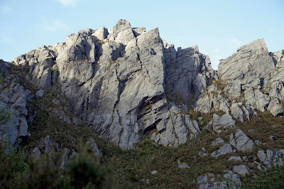
[Quartzite crags looming over Lake Oberon] 
Most photographs of Lake Oberon ooze tranquility, but in reality it’s a wild and restless type of tranquility. The small lake sees waves often enough to pound the tough quartzite into sand. And around it the sodden, stunted, contorted vegetation speaks of roaring winds, vicious downdrafts and frequent rain.

In my Parks and Wildlife days I remember speaking with some Japanese tourists who had one day spare in their itinerary. This was in Hobart, and they pointed to Peter Dombrovskis’ poster image of Lake Oberon, and said “so we will walk there”. When I told them it was not possible in one day, their look said that I didn’t know what I was talking about. How could such a beautiful place not be easily reached!?

Now, as a fresh gust hits and I turn back to the relative shelter of my tent, I ponder how that couple would feel if they were here now. The gap between romance and reality is often very stark in Tassie’s south-west wilderness. It’s with that stark reality in mind that I once again raise with Mick and Eden the question of where to next.


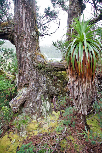
[Pencil pine and pandani shelter near Lake Oberon] 
As we struggle to keep our dinner from blowing off our plates, Mick begs a place for the night in Eden’s roomy tent. Quickly, though not without some agony, we realise we’re going to turn around. Tomorrow’s weather will be like today’s: blustery, showery and generally tough. But it’s what’s following these strong nor-westerlies that’s got us more concerned. South-westerly winds of gale force and pelting rain are said to be coming. We can either face that on the highest, roughest, most unprotected section of the range, or have it blow us back the way we came. We choose the latter.

So day 5 sees us packing up and leaving Oberon’s ominous beauty behind us. There’s a mixture of relief and disappointment, but we console ourselves that the Arthurs are not going anywhere in a hurry. Some of us will be back. More immediately our apprehension returns, as we have the steep, slippery climbing gully out of Oberon to negotiate, and then plenty more hard walking before we’re back at Lake Cygnus. The wind continues its brutal barrage, with pellets of rain sometimes added into the mix. But by now we’re walking fit, and we get up the gully without incident. We eventually reach Cygnus by mid-afternoon.


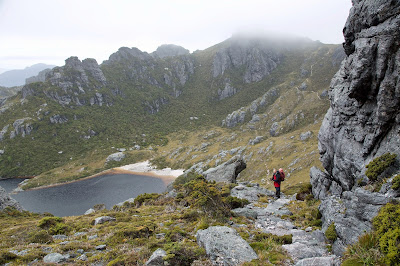
[Mick approaches Lake Cygnus] 
As we’re planning an early escape the next morning, we dry as much gear as we can, and eat an early dinner. Mick puts up his tarp as a shelter for us, but chooses again to bunk in with Eden. He's nestled his tent up against a couple of low-growing myrtles with delightful fresh gold and bronze foliage, which he's decorated with drying clothes. I can't resist dubbing it “The Garden of Eden”.

Mick’s decision will save packing time in the morning, and keep the rest of his gear dry if the heavier rain comes early. It doesn’t, but the wind does. About 3am I’m woken by a loud, persistent flapping. Mick’s tarp has come free. I stumble out into bright moonlight, surprised out of my grumpiness by its beauty. Once I get its guys untangled, I roughly fold the tarp and stuff it in their tent vestibule. I resist adding the loud expletives that are top of mind. I figure the patience they’ve shown the oldest party member deserves at least that much.


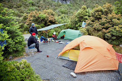
[Downtime at Lake Cygnus] 
Before 6am we’re up and about, anxious to get off the range before the deluge hits. The sky is a heavy, dark grey, and the wind is strong, but we stay dry for the pack up and ascent back towards Mt Hesperus. Around then our luck ends, and the wild murk unleashes on us. Rain squalls lash us and the wind causes us to stumble drunkenly.


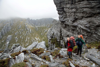
[Mick and Eden between a rock and a hard place] 
For several more hours we walk on, barely stopping because its so miserable. The rain is now constant and horizontal. I’ve been wearing a new rain-jacket, and for five and half days it has kept me dry. Not any more. Water is now blown down my neck, up my sleeves, under my hood, through any gap it can find. We’re all so thoroughly soaked that even our sandwiches – hurriedly scoffed at Junction Creek – are sodden to the consistency of milky Weetbix.

We barely notice how wet the crossing of that creek is. After it I put my head down, slosh through the freshly-reinforced mud, and will the carpark to come. Of course it doesn’t. Tracks don’t shrink in the rain; if anything they expand. This day is surely one of the most miserable I’ve ever spent bushwalking. It takes us nine hours to get from Lake Cygnus to the Huon Campground, seven of them in solid, horizontal rain and gale force winds.


Only as we get towards the end does the rain let up, as though it’s now done with us. A couple of times my hopes are raised as I think I recognise the end of the track. But I should know that a cardinal law of bushwalking is that false hopes must be dashed. It’s another 40 brutal minutes before we stumble up the final forested bit of track and into the carpark. I hear a loud voice screaming “YEESSSS!” and am slightly surprised to find that it’s my own. Mick staggers up behind me mouthing something about the Arthurs having chewed us up and spat us out. At best it’s been a retreat, more likely a rain-soaked rout. But for now we’re happy to feel that R is for relief!

Thursday 31 August 2017

Back to the Arthur Range 2: O is for ...

“The track went up and down in see-saw fashion, one moment reaching the heights of a sharp peak; the next plunging down to a mountain lake. To do that sort of walking, carrying a 50 lb. pack, there have to be compensations, and there certainly were. I doubt if I have ever been in more breathtaking country.”

- extract from a letter I wrote after my 1982 Arthurs trip.


[One of my 1982 photos showing the Arthurs' skyline]
In the same letter I reported that we had only one day of rain in a whole week on the range. If the first day of our 2017 trip has me questioning my wisdom in coming with Mick and Eden this time, those earlier words show that it wasn’t solely a case of amnesia.

On day 2 we wake to cloud. Showers are scudding by, and there’s a swirling wind up where we’ll be going today. We move slowly, timing our eating, toileting and packing up around breaks in the weather. Apart from anything else it’s so good just being in this stunning place that hurrying somehow seems out of order. Anyway I’m a little stiff and sore after yesterday, so slow is good.

But after breakfast the degree of purpose grows, especially when a drying wind gives us a chance to pack up semi-dry tents. That done we have a quick look at the maps before hoisting our packs for the climb out of Lake Cygnus. Today is not a long day, just 2½ to 4 hours of “reasonably easy walking”, according to Chapman. That’s if you don’t do side trips to various peaks. And by the look of the cloud levels, we probably won’t be tempted to do that.


[Lunch between Mt Hayes and Square Lake]
That initial climb is tough first thing, but that’s the reality of most days on the Arthurs. By the time we reach the ridge it’s cold and wet, and a keen breeze is whistling around the rocks. Somewhere above us is the cloud-shrouded bulk of Mt Hayes. We have to “sidle” around this, “descend steeply” from it, then “traverse” towards Square Lake. Take these innocent sounding words, mix them with showers, cold, thick cloud and a stiff breeze, throw in a rough and rocky track, and you end up with tough walking conditions. Even in the rarest, fairest of weather, this is not an easy walk.


[Christmas Bells brighten a moody Square Lake]
We shelter behind rocks in a saddle beneath Procyon Peak and have a quick lunch. The sun almost shines a few times, and we get glimpses of Hayes and beyond. But by the time we’re slowly climbing back towards Square Lake, it’s raining again. The ascending traverse from Square Lake to Lake Oberon is slow. Navigation is always tricky in clag. I remember that we have the mother of all “steep descents” to reach that lake, but by the time we reach it, the thick cloud disguises it. There might be a degree of mercy in that. As we peer down, there’s just a swirling grey abyss. A dark cliff blends into the mist on one side, and on the other there’s just menacing mist.


["Seriously, down here?" Eden descends towards Lake Oberon]
It becomes one of those tracks that you start to follow, decide must be wrong because it looks impossible, and look around desperately for a better way. Of course there isn’t a better way, and as though to convince us, we get a few glimpses of Lake Oberon way below us. Mick lets out an “Ah hah”, exultant that we’re getting close to this iconic place. Not wanting to get ahead of ourselves, we quickly re-focus on the immediate task. How do we actually get down?

We talk about taking off our packs, and roping them down. Instead we put on our scrub gloves, to give us better grip on the cold, wet rocks. Then slowly, one at a time, each of us grips, grunt and bum-slides a little further down. We are keeping close to the improbable security of the cliff, which has water dripping from it. At the end of an already taxing day this is wearing, and scaring. In conditions like this we could easily fall and be seriously injured.


[The cloud lifts, and there's Lake Oberon!]
When Eden, who is out front, let’s out a “woo hoo”, our mood suddenly lightens. It’s not the bottom – far from it – but it’s the end of the worst section. As if to reinforce that, we come to an unexpected section of boardwalk, which takes us on a circuitous route through wet forest, then onto rocky knolls, and finally down to Lake Oberon.


[A tiny creek in the Lake Oberon basin]
We’re all glad, but Mick is ecstatic. Like generations of those who love wild Tasmania, he has always admired Peter Dombrovskis’ photograph of Lake Oberon. As we set up our tents in the well-sheltered campsite, he admits that this is something of a pilgrimage for him. And despite – or even because of – the wild weather that’s followed us down here, he’s not at all disappointed with the reality of this place. Oh yes for Oberon!

Thursday 22 June 2017

Back to the Arthur Range 1: A is for …

I feel it deep in the pit of my stomach, although I’m not quite sure what to name it. I eventually decide it’s apprehension. Unlike Mick and Eden, the two other walkers in the party, I’ve previously been to the Western Arthur Range in Tasmania’s south-west wilderness. It might have been 35 years ago, but I know what to expect. I remember it as one of the hardest, most epic walks of my life: a rite of passage to an aspiring bushwalker.


[The old H-frame pack, as used in 1982] 
That 1982 trip was only my second proper expedition into the Tasmanian wilds. I was still in my 20s and had only rudimentary gear. I also had barely a clue as to how you prepare for such a walk. Into my old H-frame pack I threw whole potatoes, zucchinis, carrots and onions, plus fresh steak, some cans, and more clothes than I could possibly use. It’s a wonder I survived.

Youthful ignorance notwithstanding, I at least had the sense to be a little apprehensive before we left, especially when the serrated outline of the range reared up at us we neared Scotts Peak. I remember naively suggesting that the track must sidle around the peaks, rather than going over them. A tart “Nup … up and down the whole lot” quickly set the butterflies flapping.


[Surveying the Western Arthur Range from McKays Track] 
Afterwards my main responses to the trip were a peculiar mix of vertiginous joy, stunned awe and fear. We had walked through a landscape that shouldn’t exist in this “wide brown land”, on a route so steep that it hadn’t looked remotely passable.

But back to January 2017, and my renewed acquaintance with both the Arthur Range and my apprehension. The source of the latter is not just my time-eroded knowledge of what’s ahead, but also the nagging thought that my now 60+ year old body is not going to like this. Add a very ordinary looking weather forecast, and you’ll forgive a few butterflies.

We start promisingly. The weather is cool, the cloud patchy, and there’s a strong breeze. That’s better than par, this being the south-west. We make good progress, soon breaking out onto the white quartz of McKays Track. Our path meanders across the wide buttongrass plains that lead to Junction Creek, and the moraine by which we’ll access the range.


[Buttongrass and track near Junction Creek] 
All the way the Arthurs loom ever larger, and the amount of mud increases. By Junction Creek we’re lightly marinated in mud, but the creek is flowing swift and clear, and we clean off a little as we cross to the southern side. With plenty of daylight left, we find some good campsites and put up two tents and a tarp. Mick has chosen to combine a tarp with a bivvy bag as an experiment. As he fiddles with the setup, we offer helpful comments like “What could possibly go wrong?” But we do give him a hand with some of the guy lines, and eventually he looks set.

By morning the clouds have thickened, and they’ve flattened the top of the range. As we reach the toe of Moraine A, showers are scudding by. The track onto the range looks brutally steep, an off-white ribbon winding through tawny buttongrass pocked with quartzy outcrops and bands of scrub. As we climb, the showers come and go. We put on our rain jackets, climb, sweat, take off our jackets, stop, rest, moan a little, eat and drink a little, then repeat the process for the next couple of hours.

It’s plain hard work, ‘though there are some sweet moments. The piping and chipping of the honeyeaters, and the bright glow of the wildflowers that thrive in this harsh environment, are somehow encouraging. And although it’s a couple of weeks after Christmas, nobody has told the Christmas bells. Their beautiful scarlet and gold bells are continuing the festivities, and they too lift my thoughts beyond my aching body.


[Christmas bells and quartzite rock on Moraine A] 
We pause briefly beneath an inadequate rock overhang for a quick, wet lunch. Looking up, it appears we don’t have too far to go. But appearances do what they often do on a bushwalk, and by the time finally top out, we’re exhausted. We flop down in patchy sun on the flanks of Mt Hesperus to rest and drink. When Mick discovers we have a phone signal, it turns into a longer break. Our mobiles are quickly out and we’re checking in with home. I would normally see mobile calls as an intrusion on a wilderness experience, but this time it feels important to talk to Lynne. We’ve had a tough family time over Christmas. Our 12 year old granddaughter from Launceston has had a serious fall, and has broken bones in both her ankle and her jaw. She and her family have had to spend weeks with us in Hobart, with numerous hospital visits, some surgery, and a lot of anxiety.


[Wildflowers near Mt Hesperus]
My usual role in this sort of situation is to be positive, to look for solutions, to jolly everyone along. But a couple of days away from it all has helped me to realise that deep down I too have been anxious about my granddaughter. And I’ve added to that anxiety by taking on this physical challenge in the Arthurs. I get to say this to both Lynne and my daughter, and it feels good to better understand the source of those letter A feelings that have inhabited my stomach.


[Massed flowering of Tasmanian purplestar] 
Our calls complete, we don our packs and meander around and over Mt Hesperus. From there we angle steeply down through a burned-out area. The fires have been kind to some of the plants, and especially the Tasmanian purplestars, which are flowering more profusely than I’ve ever seen. We then sidle around Lake Fortuna, giving it more than one “could we camp there?” glance, before finally reaching the steep descent to beautiful Lake Cygnus. 


[Finally ... Lake Cygnus] 
By the time we get to the lake we’re exhausted again. I take small comfort from the fact that my 30 and 40 something-year-old companions are just as spent as me. Trying to set up tents when you’re in that state makes for comical scenes. After a certain amount of muted hysteria, we get our shelters up. Then it’s a quick meal and some vague chat about tomorrow. While apprehension and anxiety have both accompanied me today, I'm happy to add achievement to the lexicon. And then I succumb to the call of the sleeping bag.

Friday 26 May 2017

Derwent River Walks: The Colours of New Norfolk

[Continuing a series featuring short walks along Tasmania's Derwent River]


[The Derwent River at New Norfolk] 
Any time of the year is a good time to try the short walks around New Norfolk. But could there be a better season than autumn, when the poplars and willows colour up; the winds calm down; and the broad Derwent seems in no rush to get to the sea?

I planned to do a circuit walk, so left my car at Tynwald Park, just on the Hobart side of town. An inviting gap in the golden poplars revealed a pedestrian bridge over the Lachlan River. This led to the Bicentennial Track, which follows the river upstream. I sampled the track for a while, then walked across town to access the New Norfolk Esplanade.


[Autumn colours in Tynwald Park] 
A 1km trail goes right along the southern bank of the Derwent. There I paused to chat with an angler (no, the fish weren’t biting) and to photograph some of the deciduous reflections in the beautiful, calm waters.


[Steep steps on the Derwent Cliffs Walk] 
I continued along the Esplanade north-east to the start/finish of the Derwent Cliffs Walk (it can be walked in either direction). I climbed steep stairs around some riverbank cliffs, before topping out some 20m above the Derwent. The sandstone cliffs offered great views both up and down the river, and was the perfect place for a scenic drink break. A few ducks were feeding busily on the river, and some lapwings “ack-acked” along the bank. But otherwise all was calm and quiet.


[Ducks on the Derwent River] 
As I continued downstream from the cliffs, I met the first of several dogs being walked around this popular track. Much of the well-made, multi-use track is also suitable for prams and bicycles. The cliffs had finished on my side of the river, but large cliffs still dominated the far bank. A popular walk to Pulpit Rock can be accessed via the Boyer Rd opposite this track. I’ve heard the views are great: that’s one for next time.


[The view from Derwent Cliffs] 
As the track curved around the river bend it flattened out. Now there was water on both sides of the track, the river itself to one side and some billabong-like ponds on the other. Waterbirds, honeyeaters and other smaller birds chatted and flitted all around. After a very leisurely hour and a quarter I was soon back at Tynwald Park, walking again alongside the tiny Lachlan River rather than the mighty Derwent.  


[Alongside the Lachlan River] 
I decided I still had time to drive to the Peppermint Hill Lookout for a view over the town and valley. Finally I wanted to walk across the main bridge over the Derwent. On such a calm, fine day, close to the peak of the valley’s autumn colouring, it was a perfect way to round off my visit. But as usual I’d found plenty of reasons to come back for more.

*This series was prepared for the Derwent Estuary Program and Greater Hobart Trails