Showing posts with label cairns. Show all posts

Thursday, 28 November 2024

A Loopy Walk on the Plateau 3

Day 3: A Trip to Cairns

“All journeys have secret destinations of which the traveller is unaware.” – Martin Buber


What a difference blue sky and time on a summit can make! We descended from Turrana Bluff gradually, happily; delighting in the lack of full packs and the wide vistas all around us. We were back at our campsite around 11am, and quickly finished packing before setting off for destination not-quite-known. In theory we should find Ritter’s Track by mid-afternoon. A few years before, a little east of Pencil Pine Tarn, we had located some of the cairns that marked Ritter’s Track. That time we’d followed them south and west towards the Walls of Jerusalem. This time our plan was to go the other way. We would pass east of Lakes Lexie and Gwendy in search of some of the northern markers of Ritter’s Track. We were now thinking of the walk as Ritter 2.0.


[Tim D finds water and shelter]

The day had become warm, the sun strong. Full-pack, off-track walking, with its attendant high leg-lifting, is thirsty work. By lunchtime we were in need of both water and shade, and found them in the delightful shade of some pencil pines beside a small pool. If we’d been told two days ago that we’d be sweating, putting on sunscreen, and hiding in the shade from fierce sun, we’d have shaken our heads in disbelief. Welcome to November in the high country: freezing one day, burning the next!
 
Over lunch our GPS geeks, Tim D and Larry, began comparing data on the whereabouts of the nearest Ritter cairn. We were supposed to be walking directly towards one, but we knew we weren’t guaranteed to find it. Ritter’s Track is not like a conventional bushwalking track: mostly easy to follow, with markers and an obvious ground trail. Rather, at least from our previous experience, it’s a vague route, marked by sometimes hard-to-find rock cairns, and with little or no ground trail. After all, it was created over 100 years ago to drive cattle towards grazing grounds in the Walls of Jerusalem area, and it‘s been many decades since it’s been used for that.


[Looking down towards Lake Lexie]

We crested a scrubby high point overlooking Lake Lexie, a lake we’d wandered past on previous trips. We did so again, making for some low rocky hills, beyond which lay Lake Gwendy. After that, Larry told us, we should be getting close to a Ritter cairn. By now some of us were growing weary, and even low hills felt like hard work. The prospect of finding a cairn was less thrilling than that of finding a good campsite. We plodded on, eventually dropping down through scrub towards a small open lake. A few of us were ready to stop, but this looked like a campsite only for the desperate. After a brief discussion we walked on.


[TimO at Lake Lexie, with the "low hill" behind]

We clambered over another rise and found a larger, unnamed lake. Larry said we were only a few hundred metres from a cairn, but in this sort of country that can be half an hour’s work. We compromised by continuing up the eastern shore of the large lake vaguely close to the direction of a cairn. By now most of us were only interested in finding a campsite, at least for today. 


[Our eventual campsite: a hidden gem]

We'd been spread out searching for a while before Libby walked upslope from the large lake, and called back that she’d located a promising possibility. It proved to be more than that! She’d found a lovely small lake, fringed by pencil pines, and with a group of ducks bobbing near the far shore. What bliss! We each managed to find a spot for our tent, and settled in “tired but happy”, as the cliched school composition had it.


[Libby celebrates a card game win]

Indeed we were happy enough, and the weather was fine enough, that we sat around playing cards after dinner. As we finished our games, a waxing moon rose into the clear evening sky, a change of the guard signalling bedtime. With this wonderful campsite it seems we’d landed on our feet. That said we'd be even happier once we were off them and in our tents.

Thursday, 16 December 2021

Walking the February Plains 2: Discovery

We’re lulled to sleep by a frog symphony. Urged on by their own inscrutable drives, they variously bleat, creak and croak through the night to an audience that wouldn’t normally include us. But we’re here, and what a privilege it is to have these calls dampen the din of our normal lives.


The morning breaks fine, with a cloud cover that harbours no threats. We have a slow brew and breakfast, chatting easily about many things before eventually turning to the topic of “where to now?” South is the general answer, with maybe a visit to Lake How and a wander to a high point a little west of there.


Tim eyes the peaks of the Overland Track

We take a meandering route to the lake, heading first to “the grandstand”. We’ve visited this high point before, and been stunned by the views. Again it doesn’t disappoint. We can clearly see almost every mountain of the Overland Track, from Cradle to Olympus. To the south-east are the high points of the Walls of Jerusalem, and north and east many more mountains, including Tim’s home peak of Mount Roland.


Reflections in a pool beside Lake How

Within an hour we’re standing by the shallow shores of Lake How. As pleasant as it is, we’re glad we didn’t tried to camp here. It’s a shallow scoop in a soggy, grassy plain, unprotected by bush or trees. We have a scroggin break and discuss our onward route. I’m pretty much in Tim’s hands, having not been this far before. We decide to climb a nearby hill and the ridge beyond it, to reach the probable high point of the Februaries, to the west of the lake.


Towards the Overland Track from the Februaries' high point

When we get there we again find exhilarating views. The deep valley of the Forth River lies between us and the Overland Track. Our equivalent latitude is well south of Barn Bluff, which we can see clearly. We stop for a very early lunch, and reminisce about walks we’ve done in these nearby mountains. For Tim it’s a significant anniversary: three years since a cardiac arrest on the side of Mount Roland almost ended his life. As we look at Barn Bluff we recall him having, in hindsight, what was probably a warning episode. When we were climbing the steep bluff, Tim was straggling behind when he would normally be leading. At the time he put it down to having given blood the day before we left. Now, by-pass and other surgery behind him, Tim is back to his best, and I’m grateful to be the one straggling behind.


We decide today will be a short day, and amble downslope, thinking we’ll loop back to our home lake for an early finish. But as we cross the shallow valley above Lake How, we make an odd discovery. On the valley flanks, on no obvious route, is a large rock cairn. We puzzle over it, wondering if it’s random, or linked to others. As we walk out of the valley we find another and then, a little further on, two more.


I’ve thought for some time about Frédéric Gros’ theory: that walking through such landscapes detaches us from daily trivia. I’ve certainly experienced the truth of that, but I’ve also pondered what happens to us after we’re detached.  Gros hints at us then becoming attached to that which matters. We’ve experienced some of that at our lakeside camp, and elsewhere on this walk. But I think the freed up mind is also now open to uncovering – or discovering – things which have been hidden from us by our cluttered minds.


One of the probable Stock Route cairns
So here we are, uncluttered by the thought of having to follow a track – there are virtually no walking tracks in the Februaries – and we discover a track! Actually it’s a route, as there’s no clear ground sign of people or animals walking this way. But Tim’s straight onto a theory. We may have discovered an old stock route: perhaps the February Plains Stock Route. If we’re right this route, pioneered by the Field family, dates from the mid 1800s. It was used to drive cattle from the Borradaile Plain through the February Plains to the Pelion Plains. Tim thinks he has seen one or two of these cairns on a previous trip, but we are now finding a continuous series of them.


Tim logs another possible cairn

We dutifully stop at each one, and Tim enters their GPS coordinates into his device. We photograph some too, noting that they’re far less elaborate, and less covered with lichen, than the cairns we followed on Ritters Track, east of the Walls of Jerusalem, last year. You can read more here: Ritters Track


This kind of discovery becomes quite addictive, and we describe a wider arc than we otherwise might have as we walk on to “just one more” cairn. Eventually we cut back to our home lake, but with the idea that we may try to resume the cairn search on our last day. However when we get back to our tents, Tim’s explorer blood is still bubbling. Given it seems to be a day of discovery, he’s all for trying to find signs of another 19th century track, that of E.G. Innes. This is thought to be on the eastern edge of the Februaries, perhaps a few hundred metres from our lake. By now I’ve taken my boots off, so I only follow part of the way, and soon bow out to photograph the nearby flora. Given their subtle beauty, that will be discovery enough for me. 


Rubus gunnianus (Tasmanian alpine raspberry)

Friday, 16 April 2021

Central Plateau Variations: Part 3


[Who else has walked here?]

It’s rare to walk the Earth and not be following in the footsteps of others. At our first campsite, we’d sat relaxed and content – when the weather allowed – and imagined the Palawa, Tasmania’s Aboriginal people, doing much the same over tens of thousands of years. The shelter, the water, the hunting, the clear views, would all have made this a wonderful summer place. What stories, songs and dances must they have shared here, and passed on for countless generations?


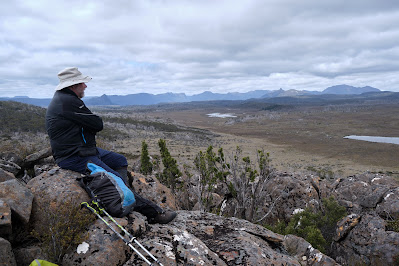
[A place of contentment]

For the Palawa, European invasion stopped all that, whether though disease, forced eviction, or deliberate killings. Others would now eye off this high country for their own purposes, and they did so quickly. In the 1830s, when G. A. Robinson (the so-called protector of Aboriginals), travelled through the Central Plateau to round up any remaining Aboriginals, he noted that “wild cattle was seen grazing … and several young calves appeared among them”. 

So this “empty” Central Plateau became a favoured place on which to summer livestock. It’s estimated that between 1860 and 1920, up to 350,000 sheep and 6,000 cattle were summered up here annually. This is tranhumance on a grander scale than I’d ever imagined. Gradually cattle became more highly favoured than sheep, and by the late 1870s, settlers from the Mersey Valley and surrounding districts had acquired cattle grazing leases on the plateau. They built tracks such as Higgs Track, Warners Track and Dixons Track so they could drive stock up to the high country each summer.

But as we were discovering first hand, the “warmer” months on the plateau can still be harsh, making navigation difficult. Around 1913 a farmer from Meander named Charles Ritter, who had leases in the Walls of Jerusalem area, thought to make a safer all-weather drove route from the top of Higgs Track/Ironstone Hut area to the Walls. It was probably completed by 1918, and became known as Ritters Track. While it was called a track, I had long wondered whether it was ever more than a series of large rock cairns that could be followed even in rough weather. On our fourth day, we were hoping to find out for ourselves.

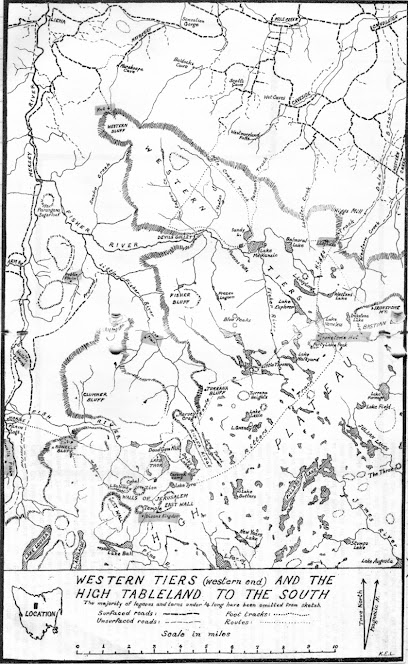
[An old sketch map by Keith Lancaster, showing Ritters Track]

The night had been exceedingly windy, and none of us had slept much. Jim wasn't feeling great after a poor sleep punctuated by some unwelcome toilet trips in the dark. We’d already decided to adapt our schedule, allowing for another night here at Pencil Pine Tarn, and a short wander today. That meant Jim could stay back and “keep our camp secure”, which he generously volunteered to do. The rest of us would pack lunch and a day pack, and go in search of Ritters Track.

Three years earlier we’d half-heartedly looked for some cairns between here and Long Tarns. That time we’d only had some rough, third-hand notes, and our explorations hadn’t allowed us to say with any certainty that the cairns we found were part of Ritters Track. This time, we had not one but two lots of GPS data indicating the supposed locations of Ritter’s cairns. The only thing against us was the weather, which remained showery and ferociously windy: in short exactly the kind of weather Ritter hoped his track would deal with.


[Tim contemplates the route]

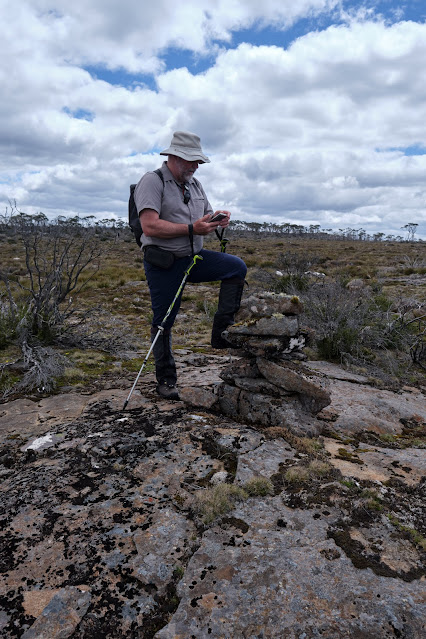
Tim and Larry, our two GPS-bearers, lead the way, at first taking us almost east, seemingly back to where we’d come from. I expressed my surprise, but Tim assured me we’d soon swing south. And once we’d picked up a cairn, we’d start heading more south-west. 

Before long one of our navigators signalled us to join him. According to his GPS, we were within 20 metres of one of the cairns. But what were we looking for? A pile of rocks in a landscape made of rocks? And rocks that have been glaciated, ice-shattered, and scattered about willy-nilly over aeons? The five of us wandered about, a little clueless, until someone finally had their eureka moment. 

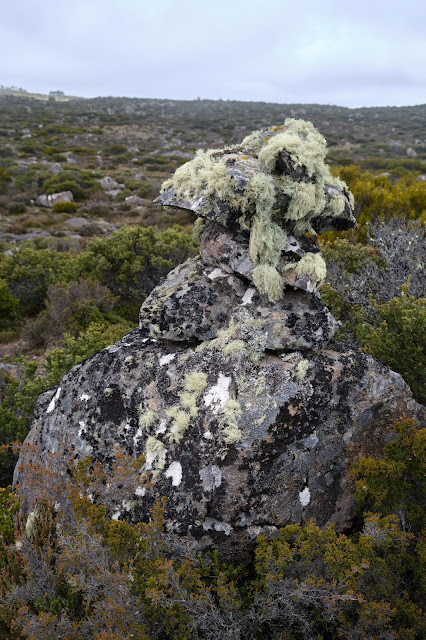
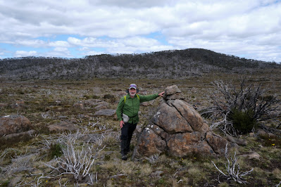
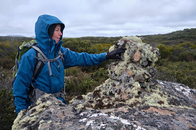
[Surely a Ritters Track cairn?]

We hurried over towards an obviously human creation: four or five rocks piled high atop a large boulder, forming a rough and wonky pyramid. If the cairn’s size wasn’t the clincher, the mop of long, grey/green lichen on the rocks was. This indicated it was no recent or random cairn, but one put here deliberately, and many decades ago.

[Tim and Larry spy out the next cairn]

The next couple of hours saw us slowly following our navigational nerds from cairn to cairn. Sometimes the next cairn was visible from the current one, but at other times we were glad to have the GPS data. This was not the sort of “track” that, once found, you could easily follow. Apparently Ritter didn’t choose a straight-line route towards the Walls of Jerusalem (which today was clear to see ahead of us). Rather he kept to higher, less boggy ground, winding around the plateau on ground over which cattle could more easily move.

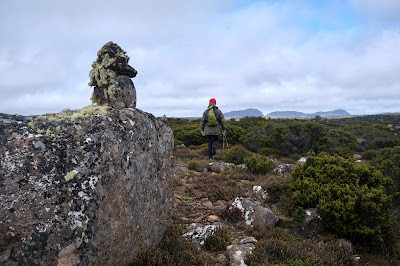
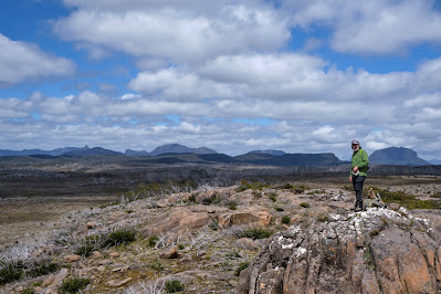
[A clear view towards the Walls of Jerusalem]

Another matter sometimes confused us. We found multiple other cairns dotted across the landscape. Some we considered Ritteresque: good copies, but not originals. Others were mere wannabes: poor imitations that lacked size or age, the creation perhaps of bushwalkers or anglers. Our rule of thumb was that a true Ritter cairn would be substantial, vaguely pyramidal, made with care, and bearded with lichen. We came to admire the labour that Charles Ritter, presumably with the help of his fellow drovers, had put into building the many dozens of cairns. The heavy rocks would have taken some effort to move, and the conditions for doing that work would seldom have been ideal.

[Libby inspects another genuine Ritter cairn]

As we walked, we imagined driving cattle through this terrain. How different it would have been to walk or ride here accompanied by the sound of hoofs and mooing; the steam from their breath; the swish of their tails; the slop of the slush beneath their hard hoofs; the smell of dung and drover alike. We could admire, celebrate even, the hard labour of these cattlemen, without wishing that this was still happening. Clearly driving and grazing cattle between here and the central Walls – where the best grazing was found – made a mess, and altered the landscape hugely. The unsustainability of the practice, both environmentally and economically, led to grazing being prohibited above the 3000ft contour (914m) in 1973. 

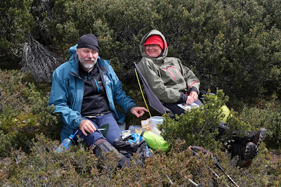
[Tim and Merran at our lunch stop]

While it had been fascinating to follow the footsteps of Ritter, after lunch it was time to complete our off-track loop back to the campsite. We were beginning to wonder how another grey-bearded fixture was doing. We found Jim relaxing in the sun, which had finally made a welcome return. As Tim placed his small solar panel in the same patch of sun as Jim, I remarked that we now had two solar collectors. Then, over a relaxing afternoon tea, we swapped stories of our day. Jim noticed that a couple of us were red in the face, and when we conjectured that a combination of windburn and sunburn might be to blame, he was all the gladder for his rest day.

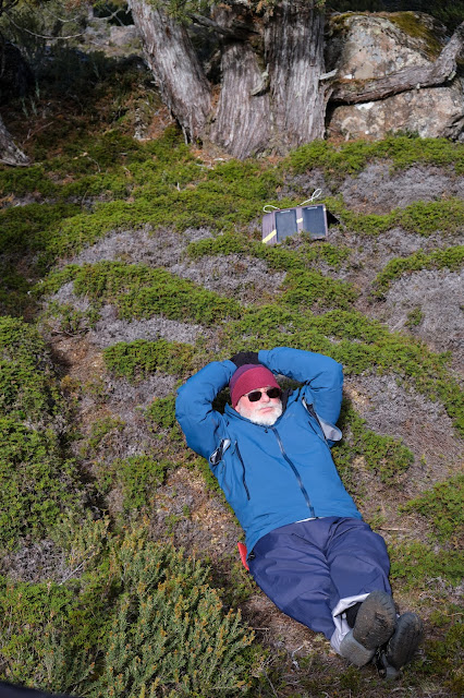
[Two solar collectors hard at work]

When the shade from the pines started overtaking us, we followed the sun up the hill. It was good to gain a little altitude, to change our perspective, and to feel a windless sun after 48 hours of gales. Eventually we wandered back down to the camp, and we were soon off to our tents. How good it felt to be in that now quiet space, without wind tearing my every thought away.

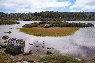
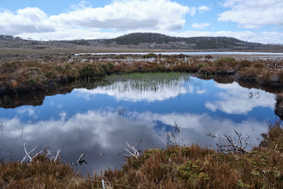
[A calm Pencil Pine Tarn]

In that calm state, I began to ponder on our walk, and to think about the footsteps we had followed to this point. Whether it was those of the Palawa, those of the cattlemen, or those of the pioneer bushwalkers, the ones who were here before us are now gone. Without feeling at all morbid, I apprehended afresh my own impermanence. None of us – grey-bearded or not – will hang around even as long as Ritter’s cairns. Sooner or later each of us will follow in the footsteps of those who are gone. 

It was in a time of pandemic, nearly 400 years ago, that poet John Donne reflected so powerfully on this. 

No man is an island, 

entire of itself, 

every man is a piece of the continent, 

a part of the main; … 

any man's death diminishes me, 

because I am involved in mankind,  

And therefore never send to know for whom the bell tolls; 

It tolls for thee.