Showing posts with label Walls of Jerusalem. Show all posts

Friday, 21 May 2021

Central Plateau Variations: Part 5

It was the light that woke me. Not just the slow leak of dawn light, but something far stronger. I emerged from the tent to a veil of high cirrus cloud that radiated a rich, warm pink. Blissful weather one day, stunning sunrise the next? Not business as usual for the Central Plateau then! 


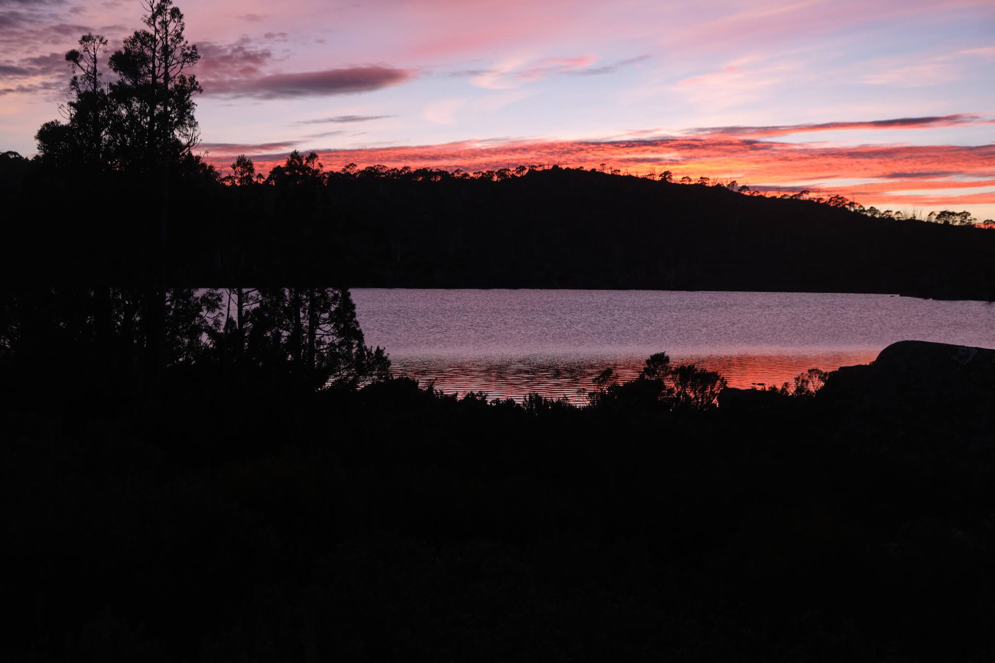
[Sunrise at Lake Tyre]


By the time I’d fetched my camera, golds and reds were joining the display, lighting up the lower clouds. The whole was then reflected back at us off the lake. As the others emerged, we wandered in wonder around the shores of Lake Tyre taking photos, or just soaking up the beauty. If we thought we were in for another beautiful day, we’d forgotten the highlands’ capacity for tricks. I’d left my tent up while we ate breakfast, hoping the rising sun would dry it a little. But as we sipped our tea, a thick mist rolled in, hiding the sun and dampening hopes of carrying out dry tents. 


[The mist rolls in: Photo by Jim Wilson]


[Larry packs up in the mist: Photo by Jim Wilson]


Reluctantly, with raincoats at the ready, we packed up soggy gear in the clammy chill. As we left the camp site the mist was thinning, the day’s air beginning to mix. But above us Mount Jerusalem, which had been roiled in thick cloud, now sent that cloud rolling down towards us, like a stern angel driving us out of the garden.


[Cloud follows us down Zion Vale: Photo by Larry Hamilton]


Our Plan A for the trip was well out of kilter by now. Instead of spending a night at Tiger Lake as originally planned, we would now bypass it and walk out to the Walls of Jerusalem carpark in one go. Tim and Merran had done this on our last walk together here, when they had to leave a day early to get back for appointments. They assured us it wasn’t difficult, though given their walking prowess, one or two of us may have taken that with a grain of salt.


[Tim leads us towards Officers Marsh]


Still, if there’s one thing that motivates bushwalkers in the transition to the finish of a trip, it’s the craving for cold drinks and hot food at walk’s end. There are unspoken rules: it has to be something you can’t get in the bush, and it has to be prepared by someone else. Grease and beer are perennial favourite ingredients, but as we walked we considered a plethora of other post-walk possibilities.


We’d left early again. There was ground and time to make up if we were going to get to lunch in time. Fortunately, whether it was because we were walking downhill, or walking towards that promised lunch, or just because we were headed for home, Jim was the most sprightly he’d been all walk. He said he still felt crook, but he was determined to get the job done.


I noticed other transitions too. Descending towards Zion Vale, we first had to cross Officers Marsh, a buttongrass-fringed boggy area. We picked our way across it, keeping to less boggy higher parts where possible. The land felt fat with water, holding onto the plentiful rainfall not only in its many pools, but also in its deep and spongy peat soils. Wallaby scats and pads, and a wombat burrow in some higher ground confirmed it was also good grazing land. 


[Wombat burrow, Officers Marsh]


As we descended, the land grew leaner, the steeper gradient aiding faster water flow and impeding peat development. Now in places the water cut down to bedrock. The flowing water was finding its voice, chattering and chuckling among the stream-bed rocks, while calling currawongs and chittering honeyeaters sang their harmonies.


It wasn’t all downhill, of course. The highlands reserve the right to put an uphill in your way, just to keep you honest. So at the end of Golden Vale, after the junction of the Fish River and Wild Dog Creek, there was a short but steady climb towards George Howes Lake. Knowing this was coming, and feeling the warmth of the day finally asserting itself, we sat on a grassy bank for a break. It was a place a few of us had stopped before. In fact, Libby reminded us, it was almost exactly 8 years ago that she’d first met us in the Walls, joining us for a day walk past here to Tiger Lake. These days we don’t feel our walking group is complete if “Possum” (Libby’s nom de randonee) isn’t with us.


On the uphill section the sun and our physical effort squeezed the day’s first perspiration from us. After the turnoff to Tiger Lake our route once again trended downhill. And now the valley was tightening even more, squeezed between the uplands of the Walls to the south, and the outliers of Clumner Bluff to the north. To avoid a steep, bluffy descent, we left the river side and took a diagonal route through scrubby bush and forest towards the main Walls track. 


[About to leave the valley]


Eventually we met that track at Trappers Hut. And here we met the first other walkers we’d seen all trip, another surprising transition. For them the hut marked the end of their major ascent for the morning. For us it was the start of the highway home: a fully-formed track, easy to follow if mildly steep. It was tempting to just put our heads down and will the carpark to come. But for a change we were now meeting, and exchanging pleasantries with, other walkers. I’m sure our words for those nearing the top – an “almost there” or a “the worst is over” – were welcome. As we got further down, it was better to stick to “where are you from?” or “what are your plans?” Sometimes the brutal truth (“You’re looking stuffed. Sorry to tell you you’re not even half-way”) is best avoided.


Such “games”, if that’s the right word, eased us to the end of the track. Even so it seemed to take longer than I expected, even though I’ve walked this track 15-20 times. It didn’t help that I’d almost run out of water as I trudged into the very full carpark. A warm mouthful from the bottom of my Camelbak didn’t quite satisfy.


Once we’d loaded the cars and made it down to Earthwater Café near Mole Creek, all that was forgotten. We’d made it in time for a cooked lunch, and there were plenty of good choices in both food and drink. To spare other diners our malodorous presence, we sat outside at a long table set beneath some large deciduous trees. If this was a compromise, it’s one I’d choose every (fine) day. 


[Happy campers at Earthwater Cafe]


For most of us it had been a great walk, with some neat variations on our last walk on the Plateau. The fierce, wet winds that blew for 48 hours or more now seemed a distant memory. More prominent was the honour we felt to have found and followed substantial parts of Ritters Track at last. Larry and Tim were especially happy about that. Their judicious use of the sometimes dodgy GPS data was superb. And if Jim’s illness had partly spoiled the walk for him, we had to applaud his guts (pun intended) in making it to the end. Besides, with a beer in hand and fish and chips on the way, he looked as happy as, well, Larry – and everyone else.  

Sunday, 2 May 2021

Central Plateau Variations: Part 4

You can’t bargain with Tasmania’s highland weather. It’s pointless arguing that you’ve suffered so much tough weather that “tomorrow it shall be fine!” Still, hope springs eternal, and the signs were good. At the end of day 4 of our Central Highlands walk, the wind had dropped to a whisper. Indeed, for the first time on the trip we could hear the night-time snores from neighbouring tents.


[An optimistic spider web at Pencil Pine Tarn]

So we began day 5 with the same optimism as the spiders that shared the pencil pine grove with us. They’d been busy spinning webs, anxious, I imagine, to catch some food after a few days of wind famine. And now the sun shone on web and tent alike. The wind a mere memory, the sky brilliantly blue, the weather angels singing: it was a perfect day to retrace some of yesterday’s wander on Ritter’s Track, and go beyond into the Walls of Jerusalem.


[Tim looking towards the Walls of Jerusalem]


We got away uncharacteristically early – for us – thinking we had a long day ahead, especially with Jim still feeling unwell. We took our time, ambling through a landscape that was now blissfully benign, soft underfoot, dotted with pools and tarns rimmed with sphagnum and pencil pines. It’s a country that’s wonderful in any weather, but this day, after those that preceded it, was one to savour. Even if it were possible for the grand scene to overwhelm, the small things could still give their quieter joy. I kept noticing, for instance, scatters of tiny yellow berries and similarly small red berries. It was as if careless wee folk had upset their applecarts.


[Gaultheria tasmanica berries ... or are they wee apples?]


Out front our two “navigational nerds”, Tim and Larry, again steered us along Ritter’s Track via the now familiar cairns. Once we passed the point we’d reached at the end of yesterday’s reconnoitre, our leaders focussed on quickly finding the next few cairns. By now Jim had slipped to the back of the group, his tank already low on fuel. When a helicopter flew over, he looked up longingly, as if it might be possible to flag a lift. It didn’t help that every time he caught up with the group, the leaders would start off again. Hearing Jim’s mutterings, I decided I’d join him at the back. Two voices might have better luck moderating the enthusiasm at the front of the group.


[Merran takes in the blissful scene]


After a couple of hours we passed between the aptly-named Long Tarns and Lake Butters, neither of which we could see. But we did find a delightful smaller lake, and paused there for scroggin and water. On our last traverse of this country, we’d been further north. I remembered that getting across Richea Ridge, west of Long Tarns, had been rough and quite scrubby. We were hopeful that this time, being further south and “on” Ritter’s Track – if you could ever truly say that – we might find an easier route, perhaps avoiding Richea Ridge altogether. 


No such luck. The cairns were now as sporadic as they were dubious. There was nothing for it but to take a rough bearing west towards Lake Tyre. That took us up, over, around and through some rocky, scrubby bush. The fact that it was riddled with Richea scoparia strongly hinted to us that we hadn’t avoided Richea Ridge after all. 


[Yes, there was NO WIND!]


[Getting closer to Mt Jerusalem]


It was hot, sweaty work on this warm, sunny afternoon. We were glad when we finally began to descend towards the valley flanking Mount Jerusalem. We were tempted to stroll down the now clear valley towards Zion Gate. However we’d learned on our last trip that we had to stay one valley east. This necessitated a bothersome trudge up a bushy hill which earlier in the morning would have seemed nothing. We had some reward at the top in the form of a view of Lake Tyre’s south-eastern shore. The sting in the tail was that our preferred campsite was on the north-western shore, another few hundred metres away, and through some scrub.


[Tent set-up at Lake Tyre, with Mt Jerusalem behind]

Still, we reached the campsite by mid afternoon. We may have been hot and tired but, in the words of young Mr Grace, "
we’d all done very well". Once we’d put up our tents, drunk a litre of water, and settled into our Helinox chairs (if we had them!) our day 5 optimism started to look justified. Some rare days in the highlands go just as you hoped they might.

Friday, 16 April 2021

Central Plateau Variations: Part 3


[Who else has walked here?]

It’s rare to walk the Earth and not be following in the footsteps of others. At our first campsite, we’d sat relaxed and content – when the weather allowed – and imagined the Palawa, Tasmania’s Aboriginal people, doing much the same over tens of thousands of years. The shelter, the water, the hunting, the clear views, would all have made this a wonderful summer place. What stories, songs and dances must they have shared here, and passed on for countless generations?


[A place of contentment]

For the Palawa, European invasion stopped all that, whether though disease, forced eviction, or deliberate killings. Others would now eye off this high country for their own purposes, and they did so quickly. In the 1830s, when G. A. Robinson (the so-called protector of Aboriginals), travelled through the Central Plateau to round up any remaining Aboriginals, he noted that “wild cattle was seen grazing … and several young calves appeared among them”. 

So this “empty” Central Plateau became a favoured place on which to summer livestock. It’s estimated that between 1860 and 1920, up to 350,000 sheep and 6,000 cattle were summered up here annually. This is tranhumance on a grander scale than I’d ever imagined. Gradually cattle became more highly favoured than sheep, and by the late 1870s, settlers from the Mersey Valley and surrounding districts had acquired cattle grazing leases on the plateau. They built tracks such as Higgs Track, Warners Track and Dixons Track so they could drive stock up to the high country each summer.

But as we were discovering first hand, the “warmer” months on the plateau can still be harsh, making navigation difficult. Around 1913 a farmer from Meander named Charles Ritter, who had leases in the Walls of Jerusalem area, thought to make a safer all-weather drove route from the top of Higgs Track/Ironstone Hut area to the Walls. It was probably completed by 1918, and became known as Ritters Track. While it was called a track, I had long wondered whether it was ever more than a series of large rock cairns that could be followed even in rough weather. On our fourth day, we were hoping to find out for ourselves.

[An old sketch map by Keith Lancaster, showing Ritters Track]

The night had been exceedingly windy, and none of us had slept much. Jim wasn't feeling great after a poor sleep punctuated by some unwelcome toilet trips in the dark. We’d already decided to adapt our schedule, allowing for another night here at Pencil Pine Tarn, and a short wander today. That meant Jim could stay back and “keep our camp secure”, which he generously volunteered to do. The rest of us would pack lunch and a day pack, and go in search of Ritters Track.

Three years earlier we’d half-heartedly looked for some cairns between here and Long Tarns. That time we’d only had some rough, third-hand notes, and our explorations hadn’t allowed us to say with any certainty that the cairns we found were part of Ritters Track. This time, we had not one but two lots of GPS data indicating the supposed locations of Ritter’s cairns. The only thing against us was the weather, which remained showery and ferociously windy: in short exactly the kind of weather Ritter hoped his track would deal with.


[Tim contemplates the route]

Tim and Larry, our two GPS-bearers, lead the way, at first taking us almost east, seemingly back to where we’d come from. I expressed my surprise, but Tim assured me we’d soon swing south. And once we’d picked up a cairn, we’d start heading more south-west. 

Before long one of our navigators signalled us to join him. According to his GPS, we were within 20 metres of one of the cairns. But what were we looking for? A pile of rocks in a landscape made of rocks? And rocks that have been glaciated, ice-shattered, and scattered about willy-nilly over aeons? The five of us wandered about, a little clueless, until someone finally had their eureka moment. 

[Surely a Ritters Track cairn?]

We hurried over towards an obviously human creation: four or five rocks piled high atop a large boulder, forming a rough and wonky pyramid. If the cairn’s size wasn’t the clincher, the mop of long, grey/green lichen on the rocks was. This indicated it was no recent or random cairn, but one put here deliberately, and many decades ago.

[Tim and Larry spy out the next cairn]

The next couple of hours saw us slowly following our navigational nerds from cairn to cairn. Sometimes the next cairn was visible from the current one, but at other times we were glad to have the GPS data. This was not the sort of “track” that, once found, you could easily follow. Apparently Ritter didn’t choose a straight-line route towards the Walls of Jerusalem (which today was clear to see ahead of us). Rather he kept to higher, less boggy ground, winding around the plateau on ground over which cattle could more easily move.

[A clear view towards the Walls of Jerusalem]

Another matter sometimes confused us. We found multiple other cairns dotted across the landscape. Some we considered Ritteresque: good copies, but not originals. Others were mere wannabes: poor imitations that lacked size or age, the creation perhaps of bushwalkers or anglers. Our rule of thumb was that a true Ritter cairn would be substantial, vaguely pyramidal, made with care, and bearded with lichen. We came to admire the labour that Charles Ritter, presumably with the help of his fellow drovers, had put into building the many dozens of cairns. The heavy rocks would have taken some effort to move, and the conditions for doing that work would seldom have been ideal.

[Libby inspects another genuine Ritter cairn]

As we walked, we imagined driving cattle through this terrain. How different it would have been to walk or ride here accompanied by the sound of hoofs and mooing; the steam from their breath; the swish of their tails; the slop of the slush beneath their hard hoofs; the smell of dung and drover alike. We could admire, celebrate even, the hard labour of these cattlemen, without wishing that this was still happening. Clearly driving and grazing cattle between here and the central Walls – where the best grazing was found – made a mess, and altered the landscape hugely. The unsustainability of the practice, both environmentally and economically, led to grazing being prohibited above the 3000ft contour (914m) in 1973. 

[Tim and Merran at our lunch stop]

While it had been fascinating to follow the footsteps of Ritter, after lunch it was time to complete our off-track loop back to the campsite. We were beginning to wonder how another grey-bearded fixture was doing. We found Jim relaxing in the sun, which had finally made a welcome return. As Tim placed his small solar panel in the same patch of sun as Jim, I remarked that we now had two solar collectors. Then, over a relaxing afternoon tea, we swapped stories of our day. Jim noticed that a couple of us were red in the face, and when we conjectured that a combination of windburn and sunburn might be to blame, he was all the gladder for his rest day.

[Two solar collectors hard at work]

When the shade from the pines started overtaking us, we followed the sun up the hill. It was good to gain a little altitude, to change our perspective, and to feel a windless sun after 48 hours of gales. Eventually we wandered back down to the camp, and we were soon off to our tents. How good it felt to be in that now quiet space, without wind tearing my every thought away.

[A calm Pencil Pine Tarn]

In that calm state, I began to ponder on our walk, and to think about the footsteps we had followed to this point. Whether it was those of the Palawa, those of the cattlemen, or those of the pioneer bushwalkers, the ones who were here before us are now gone. Without feeling at all morbid, I apprehended afresh my own impermanence. None of us – grey-bearded or not – will hang around even as long as Ritter’s cairns. Sooner or later each of us will follow in the footsteps of those who are gone. 

It was in a time of pandemic, nearly 400 years ago, that poet John Donne reflected so powerfully on this. 

No man is an island, 

entire of itself, 

every man is a piece of the continent, 

a part of the main; … 

any man's death diminishes me, 

because I am involved in mankind,  

And therefore never send to know for whom the bell tolls; 

It tolls for thee. 

Sunday, 4 April 2021

Central Plateau Variations: Part 1


[A bleak and windy day on Tasmania's Central Plateau]

When it comes to bushwalks, there’s often a degree of cat herding. Dates, walkers, venues, vehicles and variations are all part of the mix. By the time those are settled, the weather for the walk can sometimes fall into the “like it or lump it” category. Certainly it would on this occasion.

Our planned March walk would see six of us back in familiar territory, walking from Lake MacKenzie across Tasmania’s Central Plateau, into the Walls of Jerusalem. Most of us had done it 3 years earlier (see here), and loved the country so much that we welcomed the chance to return. One variation this time would be a more earnest search for the elusive Ritters Track. Another variation would be our arrival times. We’d be wandering in like Texas Rangers. (If that doesn’t ring a bell, treat yourself by checking out the first 45 seconds of this incredibly cheesy clip https://youtu.be/r2F4K7nbcgs


[Three set off from Lake MacKenzie]

Libby was the first “Texas Ranger”, having chosen to walk in a few days early, keen for some solo time, as well as to try out a new tent. Jim, Larry and I would come in next, and meet Libby at our Blue Peaks campsite. Tim and Merran would join us there a day and a half later.

One very neat variation was that Libby, Tim and Merran had already done a car shuffle for us, which would save Jim, Larry and me from having to leave a car at the Walls of Jerusalem carpark, and double back in another car to Lake MacKenzie to start our walk. So the three of us got going relatively early in cool, windy and sometimes showery weather. The weather was such that stopping was unpleasant, so we made good time and surprised Libby out of her tent mid afternoon.


[Seeding mountain rocket bring colour to an overcast day]

She had tales of strong winds, sleet and even snow. She grinned as she explained she’d secretly been hoping for some snow. Nonetheless she had possum-wide eyes as she told us about the strong winds she’d had to deal with. (Her One Planet Goondie 1 had stood up to it perfectly.) By now the afternoon was a little calmer, and the two of us with Helinox chairs settled in for a comfortable cuppa, while the other two feigned indifference.

On that count we carried a secret with us. Libby was, for now, sitting in a Helinox Chair Zero borrowed from Tim and Merran. But those two late comers would be bringing in a brand new one. It was one that we’d all shared in purchasing for Libby as a Covid-delayed wedding gift. This, of course, was to be a surprise to her. So it was hilarious when, after dinner, as we stacked the two "undressed" chairs in bushes out of the wind, spontaneous comments about the chairs exhibiting mating behaviour began to come out. How long, we idly wondered, was the gestation period of a chair? Perhaps the next morning would be a little too early for the appearance of any offspring. But later in the day: who was to know?


[The Helinox chairs getting "acquainted"]

Other excitements were to occupy us most of the next day. Neither Jim nor Libby had been to see the enormous cushion plant “colony” that Larry and a few of us had stumbled upon some years back. The weather more or less cooperated, and we set off towards that wonderfully small eminence, Little Throne. While we were winding our way around the end of one of the lakes, I was startled to find a tiger snake stretched out on some rocks over which I’d just jumped. It seemed little interested in moving, and we took our time to gawk at and photograph this beautifully marked creature. 


[A tiger snake sunning itself]

A little while later, from the top of Little Throne, we were able to message Jim’s wife with a picture of the tiger. She, being a notorious snake-phobic, sent suitably shrieky messages back, and we all chuckled at Jim’s tease. But not long afterwards I noticed Jim was not his usual jovial self. This became more apparent when he suggested that we might make this our turn-around point. We other three, all keen to see the enormous cushion plants, outvoted him. So he shrugged and reluctantly came with us.


[Atop Little Throne]

I had a reasonable idea where we would find the cushion plants. However, not for the last time on this trip, I was glad to be walking with a navigational nerd. Larry had marked the spot on his GPS, and this saved us from wandering around too much before finding it. I’m not sure if it was the bleakish weather, or Jim’s bleakish mood, but there was not quite the excitement I’d expected in the presence of this botanical wonder. Still, we lingered and photographed at length what is still the largest cushion plant “forest” I have ever seen.


[Part of the enormous cushion plant "forest"]


[There are often many species in a cushion plant community]

Although the rain held off, the weather was becoming cloudier and cooler. So we wasted no time in getting back to our campsite, this time taking the more direct route through the lake-dotted lower country. We had calculated that Tim and Merran wouldn’t be with us until around 7pm, and in this weather that looked like being well after our bedtime. We’d all eaten dinner by 5, so it looked like some of us might have to rug up and wait around for our friends’ arrival. Then, just after Jim disappeared into his tent, we were surprised to see Tim and Merran coming over the rise and into our campsite.

They’d managed to leave much earlier than expected, and had made good time in trying conditions. We gave them a bit of time to put up their tent, but before they’d finished cooking their dinner, the rest of us started ahemmming loudly. Tim, taking the hint, reached into his pack, and Merran handed over the gift chair to Libby. “They’ve had a baby” I called out, and we all laughed at the way our jokes had fitted so well with the timing of the gift. Libby was completely ‘rapt, not least because she wouldn’t now have to settle for a damp log for a seat.


[Libby: a happy camper in her new chair]

And so we were all together at last. Tomorrow, we hoped, we’d all venture further into the Central Plateau. We knew, after all, that a Texas Ranger’s “work is never through”. 

Saturday, 24 March 2018

Crossing the Plateau 3: Touching the Walls

During the night the rain taps and whispers on the tent fly, but I’m not keen to let it in. I’m snug in my revised sleeping “system”, which comprises a new down quilt and a new, thicker sleeping mat. The mat may rustle a little more than my previous one, but that just matches the wind in the pines. The whole percussive ensemble soon has me asleep.

The next morning is very cool, and the wind is still fresh, though the rain has cleared. We pack up and leave promptly, keen to make up time after our unscheduled delay. We’re aiming first for Long Tarns. It’s an apt name for a series of interconnected linear tarns that run almost 3km from north-west to south-east. They create an effective barrier to anyone walking from our direction.


[The group departs Long Tarns (click to enlarge)] 
I’ve been to Long Tarns before, but my memory of that trip – back in the early 1980s – is not only faded, it’s geographically irrelevant. It was winter, and I’d come only to the northern edge of Long Tarns after an ascent of Mersey Bluff. An old photo has me standing at the edge of the tarn, as if pondering the possibility of skating on its thin ice. Looking back it’s dizzying to think of something like 36 years of personal familiarity with this country. It feels akin to a songline for me.


[A young Peter at Long Tarns, ca. 1982. photo by KM] 
On this occasion we’ve gone around the southern edge of Long Tarns, though only after seeing whether the summer “low tide” would allow us to cross a little further north. It wouldn’t. But we do find a couple of large rock cairns, which we guess are associated with the long-disused drove route known as Ritters Track. “Track” is now a misnomer, as there’s no clear sign of it on the ground, and we find it much easier to simply go cross-country.

After a short break at the southernmost of the tarns, we strike our first bit of scrubby country. And now we have to lift our legs higher, land them a little less certainly, and take longer in finding a way through or around the scrub. Walking poles briefly become a nuisance as they get caught in the bauera, cutting grass and teatree that sometimes block our route. The going soon becomes easier, but when we find an open meadow near a shallow lake, we’re more than ready for a lunch break. Rocks allow us to recline, the sun obliges by starting to shine, and we have a decent rest. 


[Libby enjoying the lunch break (photo by Mick Adams)] 
But just after we get walking again, trouble strikes. There’s a muffled shout from the rear of the group, and I turn to find Mick on the ground. He’s wincing and oohing, and appears to have twisted his ankle quite badly. But after a short recline, Mick convinces us it’s okay. He gets to his feet, and starts testing whether his ankle will hold his weight. It does, but some of us have experienced Mick’s “man-of-steel” stubbornness before. We strap the ankle, slow our pace, and watch him carefully for the next few hours.


[One of the slow sections approaching the Walls] 
By mid afternoon we’re drawing close to Mt Jerusalem, the first mountain on our side of the Walls of Jerusalem. There are also lakes and pools aplenty – as there have been the entire walk – but we’re on the lookout for one in particular. We’ve decided Lake Tyre, being just inside the “official” Walls, is our first potential camping spot. Again my memory of it from a 1980s trip is useless, as I didn’t camp there, and have no recollection of its potential as an overnight stop.


[Yes, we also used paper maps] 
Soon enough, as we approach the lake’s eastern edge, we have an answer of sorts. There’s a large open area near the shore, although it’s not well sheltered, and is somewhat lumpy. Everyone is tired, but a few of us decide to leave our packs and scout around on the other side of the lake. We can see pencil pine stands on both the western and northern shores, and think they might offer better shelter. It turns out that west is best, and we hoist packs and spend another 20 minutes scrambling around to the far shore. Our decision is met with some grumpiness from one (nameless) member of our party. He’s already found the perfect nook for his tent on the eastern side, and is not happy with being uprooted.


[Late afternoon at Lake Tyre] 
After a certain amount of chiding – in the gentle spirit that has pervaded our walk thus far – our grumpy friend settles into his new (inferior!) site, and eventually joins us in enjoying what turns out to be a spectacularly beautiful evening. The sun stays with us, the wind eases, and under clear blue skies the lake’s surface turns a glassy deep blue.

I had always thought this lake was named after the biblical city of Tyre – an ancient Mediterranean port – given that so many other place names in the Walls follow biblical themes. If I was puzzled that nearby Lake Thor bore a name from Norse mythology, I figured that might have been some kind of early ecumenical gesture. I have since heard that pioneer Walls of Jerusalem bushwalker, Reg Hall, had cheekily named these two lakes after two women he often walked with in the mid part of the 1900s. So it seems that Lake Tyre is named for Peggy McInTYRE, and Lake Thor for Joan THORold.


[TimO at sunset, Lake Tyre] 
The next day is relatively short. We’re keen to avoid the crowds that we know will be in the central Walls area, so we’re heading for Tiger Lake by dropping down beside Zion Gate and into Officers Creek. Along the way we sadly farewell Tim and Merran, who have to walk all the way out today.

Our destination reminds a few of us that there’s a kind of anniversary to mark at the lake. It’s five years since we first met Libby in this very park. Then new to Tasmania, she was walking solo, but happily tagged along with us when she heard we were going in search of Solitary Hut on the side of Tiger Lake. She’s been walking with us ever since, an arrangement that suits us all very well.


[Reflections: Tiger Lake] 
Five years ago, we had to watch our path to the lake very carefully, as it was far from distinct. Disappointingly it’s now impossible to miss, as someone has sprayed fluoro orange paint all along the route, on rocks, trees and even on the ground. In a wilderness zone this is a very ugly and thoughtless intrusion, and something that causes more grumpiness in our group than yesterday’s campsite shift.

Just before Solitary Hut, and a little above Tiger Lake, we find an open area in a eucalypt woodland in which to set our tents. But for Jim any hut is irresistible, and he decides to set up inside the hut. We visit him, though only briefly, and one at a time. The hut is both spartan and tiny, and turns out to have a healthy population of mosquitoes.


[Jim looking proprietorial at Solitary Hut] 
The man who built the hut back in the 1980s was an amateur weight-lifter, and incorporated a chin-up bar into the hut. He also arranged some rocks in what is now our campsite to serve as a bench press. There’s more of his story here http://www.naturescribe.com/2013/03/solitary.html


[Looking from Solitary Hut towards Tiger Lake] 
One unexpected feature of the hut is that it houses a spade. Unless you’ve spent 6 days in the bush, digging toilet holes with small trowels, you may have difficulty understanding what a magnificent luxury this is. As we depart the lake early the next morning, there seems to be a special spring in our steps. While the spade may be partly responsible, it’s also that this is to be our last day. The walk to our cars is both short and downhill, and we have the even greater luxury of a hot lunch at the Mole Creek pub to look forward to.

But while a hot meal is a standout in the short term, this walk has given us much more than that to digest. Without climbing one single mountain, we’ve seemed on top of the world – or at least of Tasmania – for much of our walk. We’ve met challenges ranging from off-track navigation and large group decision making; to injury and occasionally harsh weather. For me, although it jostles alongside 36 years of other walks in this region, it will remain one of the most memorable walks I’ve ever done. 

Wednesday, 28 February 2018

Crossing the Plateau 1: Starting with the Known


So I am on the plateau again, having gone round it like a dog in circles to see if it is a good place. I think it is, and I am to stay up here for a while. – Nan Shepherd
How blithely we speak about mountaintop experiences, as though there’s nothing but serenity to be had on summits. Certainly I’ve experienced joy, and elation, and a good degree of satisfaction on getting to the top. But like most walkers and climbers I know, I have a dirty little summit secret. Even as I sit there my serenity is tempered by restlessness. I simply can’t resist planning where to go next.


[The Mountaintop where it began, looking to the Walls] 
That’s exactly what happened last December, when four of us sat on top of an unnamed mountain near Tasmania’s Blue Peaks. As our eyes scanned the wide horizon, they were magnetically drawn towards that other favourite walking area: the Walls of Jerusalem. How about we walk across the Central Plateau from Lake MacKenzie via the Blue Peaks and on to the Walls?

If that was the germ, the infection soon spread. Those who hadn’t been on that December walk all wanted in. Via email we discussed potential dates and other logistics. That’s usually where the drop-outs start happening, but not this time. While some of us had previously walked into the Walls from Lake Ada or similar, this exact route was new to us all. And no-one wanted to miss out.

The logistics of making this a one-way walk already required some mental gymnastics. Added to that two of our walkers needed to come in late on the first day, and leave a bit earlier at the end. So the plan was to pick up one of their cars and take it, along with one of ours, to leave it at the Walls carpark. That meant starting off in three walking groups, the car shuffle walkers, the non-shuffle walkers, and the late walkers. Confused? So were we, but it all worked out.


[Sunset-lit clouds, Blue Peaks] 


One of these times we’ll get to “our” Blue Peaks campsite and find someone already ensconced. (Note to self: stop extolling the virtues of this place!) Thankfully, given we were a large group, this wasn’t such a time. In dribs and drabs we finally got to the site, and settled ourselves for the adventure ahead.

If our minds had been ruffled by travel and logistics, the sunset from our campsite smoothed and soothed them. The stunning light show went on for nearly an hour, after which Tim D and I got down to discussing walking route options. 


[Sunset from Blue Peaks campsite] 
All involved the unknown, as well as the unnamed: that is the unnamed peak that was the site of the walk’s genesis. We traced a vague route on the map that would take us between Turrana Heights and the unnamed peak, then down towards Lake Lexie. After that things got fuzzier, with words like “southish” and “westish” featuring. But we did know that we were heading towards Mount Jerusalem, and that we’d have to dodge plenty of lakes and any thicker bits of forest or scrub. Tim’s other general thought was to stick to higher country, to avoid both bog and scrub. Given low water levels in the lake near our campsite, we figured boggy ground wouldn’t be much of an issue.

It was strange to be packing up to leave Blue Peaks the next morning, given it was usually our base for a number of days. Strange too not to know where we’d be camping that night. Internet searches hadn’t revealed a lot about our route, but then that was part of the adventure. We knew about a very old cattle drove route known as Ritter’s Track. But as well as it being south of our intended route, we also knew it was sketchy. And while there were sporadic cairns along the route, the ground trail itself wasn’t likely to offer better going than off-track walking. So off-track it was, firstly around our nearby lake, then off via Middle Lake and Little Throne Lake towards the unnamed peak.

Although slowed a little by carrying full packs where we normally took day packs, the going was easy, especially as the lakes were so low that we could cut across them at times. A couple of hours in, and just before the climb that would have taken us up our unnamed mountain, we veered “westish” and dropped down to a small, pine-encircled tarn. We were now officially walking where none of us had ever been before.


[Low tide on Lake Lexie] 
The weather was clear, the sky blue, and out of the stiffish breeze the day was growing warm. After a short scroggin and drink break, we hoisted packs and walked on towards the more sizeable Lake Lexie. We dodged around its long and sometimes convoluted shores, the shallowest of which looked like mud flats at low tide. Some parts had dried and cracked so much that they gave a convincing impression of a desert.


[Yes, the Plateau was dry!]  
Towards the end of Lake Lexie we found a lunch spot that offered some shelter from the growing wind. As we ate we discussed how far we should walk before settling for the night. Opinion here was divided. Some were keen to start looking for sites sooner rather than later; others wanted to head as far towards Long Tarns as we could, knowing that late tomorrow the forecast was for rain and wind. The Walls themselves offered more shelter, if we could get there before that expected weather change.

Sometimes, however, a gift horse appears. And that was the case when we came to Pencil Pine Tarn. To my mind, it being only 2:30pm, this was a bit early to stop for the day. But once we’d wandered up slope to the pencil pine forest that had given the tarn its name, we all decided we’d be mad to miss the chance to camp here.


[The sheltered campsite near Pencil Pine Tarn] 
The beautiful, ancient-looking pencil pine grove offered superb shelter from  nearly every quarter. The site had obviously been used before, with logs and rocks arranged as camp furniture, and (sadly) signs of a past campfire. Apart from fires being illegal across this whole “fuel stove only” area, I shudder when I see signs of fire anywhere near these irreplaceable pencil pines. But I calmed down once I’d spent a few minutes among the pines, breathing in their rich, resinous scent. It seemed we had landed on our feet with this campsite.


[Relaxing at Pencil Pine Tarn camp] 
Once we’d set up tents and tarps, Tim O and I declared we were going down to the lake for a swim. There were two surprises with that. Firstly everyone else said they’d do the same, and secondly the water proved to be only a foot deep, with the tarn bottom’s mud about the same depth. So our “swim” ended up being a hilarious exercise in getting both wet and muddy. At best we managed to float on our backs, propelling ourselves along like inept, over-sized otters. Still a wash is a wash, and even Jim – not a keen swimmer – stayed in the whole time. We all came out glad he’d made the effort, and more than happy to settle back in to our brilliant campsite.