Showing posts with label Turrana Heights. Show all posts

Tuesday, 26 November 2024

A Loopy Walk on the Plateau 2

Day 2: Back to Dyer's Downfall

Past tears are present strength

– George MacDonald


We left our campsite a little after 10am and continued down Harry Lees Lake – actually a long, two-part lake – for a bit over a kilometre. There was no track, but the going was delightfully open along the lakeside, if a little scrubby once we climbed out of the valley. Again we didn’t know exactly where we were going. But Tim D and Libby, along with Merran (who missed this walk due to work obligations) had come this way before. They were sure we’d find plenty of lakeside camps in the country between Turrana Bluff and Turrana Heights. 


[Clambering around the end of Harry Lees Lake]

First we had to sidle around some lumpy, rocky country, passing some good stands of young pencil pines. Just before we dropped down into a shallow valley, we were visited by a wedge-tailed eagle. It circled us inquisitively for a while before apparently concluding we were neither threat nor food. The wind continued to be strong, and showers were still blowing through occasionally. 


Once we were in the valley, we stopped for lunch near a rock shelter. There Tim D told us the story of what happened last time he, Merran and Libby had come this way. They’d been walking towards the head of the Little Fisher valley, and had come down a steep, rocky slope just above where we were now sitting. A slight miss-step by Tim had led to a tumble downslope. Unfortunately one leg had been caught behind the other, and as he fell Tim’s full weight came down on the front leg, which crashed onto a rock. He coolly described the crack he heard as his fibula snapped.


[Pencil pine groves punctuated the walk]

After binding the leg and trying to hobble on, they all realised there was no choice but to use Tim's InReach device to call for helicopter rescue. In telling the story, Tim somewhat downplayed the pain he must have gone through, but the rest of us were squirming during the retelling. And now, some 7 months later, here he was back at the scene of the fall, seemingly quite okay to be returning to what we duly dubbed Dyer’s Downfall. His fractured fibula has healed well, but some damage to his ankle has remained troublesome. Not that we who persistently lagged behind him would have noticed!


[Tim D climbing the tufty slope]

After lunch we climbed steeply and slowly out of the valley, and up towards a shoulder of Turrana Bluff. The last part of the climb was through waterlogged tufty grass, with ample evidence of the wombats and wallabies that helped to keep the grass cropped. It was beautiful walking, though the slope was unrelenting. When we finally crested the rise, there were mutterings about going on to the summit of Turrana Bluff, which was only a kilometre or so away. I gruffly demurred, mainly because I’d found the ascent thus far hard enough without adding a further 200m climb to it. I also pointed out that I’d been there before – albeit decades ago – so I felt no “peak bagger” pull. That might not have been fair to Tim D, who had more reason than most of us to reach that particular summit. But for the time being we decided to leave the climb till later, and instead used our dwindling energy looking for a camp-able lake among the dozens we could now see below us.


[Our camp beside a tarn near Turrana Bluff]

We dropped down through light scrub and the occasional scoparia thicket, and scouted around a few pools, tarns and small lakes sniffing out a suitable spot. We eventually settled on a small tarn around which we could just fit five tents. The forecast had promised the winds would abate, so we weren’t too fussed about any perceived lack of shelter. 


That faith in the forecast came back to haunt us. Our tents were shaken all night, the strong winds and rain having come back with a vengeance. It seems no-one slept well, and there could have been much grumbling over breakfast, had the promised fine weather not finally made an appearance. Instead, by 9 am it was a revitalised team that packed day packs, and strode up the hill towards Turrana Bluff. Tim D in particular had a date with the bluff he'd so dramatically missed out on last time. With blue skies and a gently wafting breeze, we could not have chosen a better day for a side trip to the top of this impressive 1454m mountain.


[Summit selfie, Turrana Bluff]


[Tim D and Libby on Turrana Bluff ... at last] 

Beneath us we looked down on the Little Fisher Valley, and beyond that to the Walls of Jerusalem. All around us were familiar mountains, some spattered with snow, as well as some of the many thousands of lakes and tarns that dot the wondrous Central Plateau. But nowhere to be seen was my grumpy, non-peak-bagging self. I was so glad to be up here. And you can bet Tim D was too.

Monday, 26 February 2018

Celebrating 50


-->
At the crowded end of the year; the party end of the year; the too-much-to-do-and-not-enough-time-to-do-it end of the year, my mate Mick came up with an unusual idea. Wanting to celebrate 50 years on earth in a way that didn’t feel like all the other celebrations that jostle for attention in December, he chose to go bush with some mates.

The venue was to be the Blue Peaks, and in his casual come-if-you-can style invitation to his walking friends, Mick said “I cannot think of a better place to spend a few days contemplating life, the universe and everything … Or a better bunch of brigands to spend it with.


[A campsite for contemplation and celebration, Blue Peaks] 
Three of his thicker-skinned friends managed to put aside any offence, and carve out time from pre-Christmas schedules to join him. (In truth Mick probably has more friends than nearly anyone I know, but most were caught up in just the kind of rush he was keen to avoid.) So … ‘quality not quantity’ it was!

The four of us left Hobart a little after 7am, an almost indecently early departure by our standards. But it did give us the advantage of getting up to the Lake MacKenzie track head before lunch. We’d been walking just long enough to feel some of the sore bits, when I noticed an odd smell. At first it was very faint, but as I tweaked my pack and trudged on, I recognised it: the scent of stale smoke, of burned bush, wafting down valley from a fire that ripped through here in early 2016. Blackened bush soon confirmed that.

I would normally associate the smell with regeneration, fire usually being a means of bringing new growth to Australian bush. And smoke water – with just the scent we’re picking up now – is widely used in Australian native gardening to germinate stubborn seeds. But here, high in the Central Plateau, fire brings death.

It was sobering to experience the lack of new growth; the desolate feel; and the paucity of bird life. Yes, a few plants were making a slow comeback, but not the pencil pines. Their blackened trunks and empty canopies will stand for decades, slowly greying, as a reminder of that fire.


[Pencil pines killed by the 2016 fire] 

We were glad to get out of the fire zone, and into the untouched Blue Peaks area, by early afternoon. Once there, with our tents and tarps set up in the beautiful, familiar pencil pine grove, the bustle and busyness – and some of the sadness – started to fall away. And Mick began to beam, pretty sure that his idea was as genius as it was unusual. On a gently warm, sunny afternoon it wasn’t difficult for the rest of us to agree.


This being a first time visit for the other two, Mick and I pointed out a few of the area’s features to Larry and Ken. While we did so it struck me afresh that the most obvious characteristic of the place is actually its subtlety. Even the “peaks” of its names are understated hills more than peaks. But get your eye in here, and the light, the lakes, the clouds, the wildflowers, the birds, the distant mountains and the depth of the views, will do their work on you.

As it was only a week shy of the longest day, our evening meal was under way hours before sunset. I’d brought along a special birthday wine for Mick, and Larry had brought some brandy, so the celebrations began. Later, feeling suitably mellow, Larry and I decided to explore some of the nearby pools and pencil pines with our cameras. Mick, defying his increasing years, chose to take Ken to the top of one of the “peaks” for sunset.


[Sunset over lakes and pools, Blue Peaks] 
Next day the sun slept in. Given the low cloud and scudding showers, we followed suit. When we finally emerged, a kitchen tarp set up allowed us to breakfast and socialise in the dry for most of the morning. While mosquitoes threatened to keep us busy, they turned out keener to buzz than to bite.

After lunch we overcame our lethargy, put on some wet weather gear, and went for a wander in the light drizzle. We walked westward at a slow amble, the pace determined by the small wonders that kept gripping our attention. Scoparia (Richea scoparia) was blooming everywhere, its delightful flowers the antithesis of its dense and fiercely prickly foliage.


[Scoparia's multi-coloured blooms] 
At our slow pace we began to notice a few unusual things. Here and there we spied skinks scrambling over the prickly foliage to lick and nibble on the sweet blossoms, apparently pollinating them in the process. Wallabies too seemed to have a close relationship with the scoparia. I’ve certainly seem them supping on the sweet blooms. But we also began to notice that many of the bushes had been physically modified – presumably nibbled and trampled by the wallabies – to make highly protected nests.

Traces of wallaby fur and nearby scat mounds were further corroboration of that assumption. And nearly every “nest” – and we saw dozens of them – was sheltered from the prevailing westerly winds. That, combined with the numerous pads and pathways created by wallabies and wombats, led us to consider afresh the definition of the word farming. Such adaptations of the landscape certainly bore some of the marks of basic farming.

[Mick ponders a wallaby "nest" in scoparia] 
Wanting to earn our evening meal, we wandered further off, doing a loop around some lakes and low hills for another couple of hours. It was hardly exhausting work, but it allowed us to feel justified in further feasting once back at camp. Expensive wine, soft cheeses, biscotti, smoked mussels and oysters are hardly your usual bushwalking fare, but we’d all come prepared to celebrate!

The evening turned mellow in more ways than one, as the surrounding hills shrugged off the clouds, and wide, benign skies opened up around us again. Even the mosquitoes seemed to join in the celebration. At one point hundreds – perhaps thousands – lifted into the sky above our campsite, spiralling and swirling like a murmuration of starlings. We watched amazed, unsure what it signified, except that while they were up there they weren’t down here bothering us!

If we needed any confirmation of clearing skies, we had it when the night turned cold, and yet again I had reason to regret taking a summer weight sleeping bag into Tasmania’s high country. A freezing night might have been one reason we got going early. But there was also the sense that Mick and I needed to show the “newbies” a bit more of what the area had to offer. What better, we reasoned, than taking them via a few named lakes (Middle and Little Throne), past a named mountain (Turrana Heights), and to an (unjustifiably) unnamed peak.
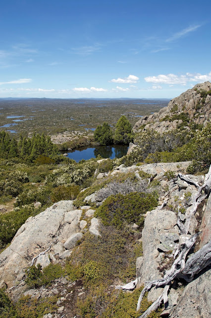

[Near the unnamed peak] 
The day was a gem, in more ways than one. The deep blue sky stayed clear all day, apart from a decorative schmear of cirrus cloud. With only day packs, and in no hurry, we strolled easily from lake to lake, hill to hill, chatting, stopping for photos, or scroggin, or just because we wanted to. Still, it was well before midday that we found ourselves scrambling to the top of our destination peak. It was as sensational as we remembered, with literally hundreds of lakes dotting the plateau beneath us, each reflecting the blue sky back to us.

Over lunch our eyes roamed south-west towards the Walls of Jerusalem. On such a day those mountains seemed achievably, tantalisingly close. We looked at our maps, traced a potential route or two, then went back to our lunch. That’s how easily a trip plan is hatched … but that’s another story.


[On top of the unnamed peak, with the Walls behind] 
With so much of the day left, we thought we’d go back “the hard way”, or at least a different way, via a hill we’d never been to, and then on to Little Throne. After a while we fanned out widely, each taking his own off-track route vaguely towards Little Throne. In the process I almost literally stumbled across the most enormous cushionplant I have ever seen. The other guys were maybe a hundred metres away from me, but I just had to call them down to see this spectacular marvel.


[Part of the vast cushionplant] 
Covering an area of at least 30m by 25m, the cushionplant – more accurately a colony of cushionplants – spread gently downslope in one continuous ruckled carpet of vibrant green. The colony had dammed a small stream, creating a shallow pool upstream, with trickling flow beneath, through and around it, creating ideal growth conditions for the moisture-loving species. It’s possible it had grown here for around 800 years, a notion that staggered us, especially given their vulnerability to trampling, drought and fire. We felt humbled to be in the presence of this giant dwarf among plants, and left with the sense that its exact location should be left unspoken. Some secrets are best kept.


[Cushionplant, pool and mountains] 
Before long Little Throne came into view. Mick and I, familiar with the usual route up the slopes of this twin-peaked, mini-mountain, thought we might try a different approach. Given that we weren’t coming at it from the usual angle, that made sense. Or at least it did until we started to ascend. Then the scrub proved thick and unfriendly, and we were hot, scratched and sweating by the time we hauled out on top.

So when we finally got back to camp, we were feeling well justified in helping Mick polish off the last of the birthday food and wine. It was a fine thing to be still in that wonderful place, winding up the 50th celebrations in style. Yet for everything we’d brought to the party, we’d been given far more by this wonderfully generous place. Good choice Mick!

Saturday, 9 April 2016

Return to Blue Peaks 3: Bluffed

I have a great affection for printed maps. I pore over them in the lead up to a walk. To me they’re a bridge between imagination and place; between mind and foot. And on the walk itself paper maps and a compass are my chief navigation tools. Strange then, and probably significant, that on this Blue Peaks walk not one member of our party is carrying a paper map.

Between us we have at least five devices with digital maps and/or a built-in GPS. And we have backup batteries so our devices don’t become useless lumps of plastic and metal. Of course I can hear voices warning how this could go astray. But ironically, on this occasion it’s actually the lack of paper maps that keeps us on track.


[Jim asks "Where Are We?"] 
What follows then is the tale of two 21st century moments, two literal turning points, that illustrate how bushwalking is changing.

* * *

The first moment comes as our party, walking off-track in search of Fisher Bluff, starts to wander like the Israelites of old. Or less grandly perhaps, like Brown’s cows. Mick and TimO are heading south of our rough bearing; the rest of us are strung out along a more northern route. Somewhere over the humps and bumps ahead is Fisher Bluff. But in this plateau country one high point looks much like the next. So which one is it?


[Mick and Tim take their own bearing towards Fisher Bluff] 
If we’d been looking at a conventional flat map, we’d probably have convinced ourselves that the northern eminence is Fisher Bluff. We just need to keep climbing. That’s when Mick’s digital map, with its GPS dot indicating where we are, puts us in our place - literally. It shows us we have to go further south. We do so, some of us contritely. Eventually, high atop a southerly bluff, we see a good old-fashioned trig point – that commonplace of highest points – and our digital hunch is confirmed.

We skirt a large linear forest of pencil pines, blessing its health and unburned state, and trudge towards the trig. It’s uphill of course, but we don’t need any form of map to tell us that.

Fisher Bluff, being one of the western most mountains of the Central Plateau, has broad views south to the Walls of Jerusalem and south-west to the highest mountains of the Overland Track. We also have close-up views of the nearby Mersey valley, one of the epicentres of the recent fires. It’s a brutalised mess of burned and blackened forest.


[Central Plateau fire damage around Last Lagoon] 
Nearer still we can see where the fire has broken out onto the higher plateau. The area around Last Lagoon has been hit hard. We see what we guess to be dead cushion plants and incinerated peat. If there’s any compensation, it’s that the fire got no further into this part of the plateau.

Our second 21st century navigational moment comes the following day. An old Irish folk song has it that “going to a wedding is the making of another”. It’s the same with mountains. From Fisher Bluff we’ve looked out on Turrana Bluff, Turrana Heights and one or two other reachable mountaintops.

Our agenda is set, and in the morning we make a surprisingly early start (for us). We progress quickly towards Turrana Heights which, being the nearest, is our first target. We're fairly sure of where we’re going. After all we’ve spied this mountaintop, shapely and prominent, from both Little Throne and Fisher Bluff. But as we’re climbing towards it, passing a nearby high “lump”, Mick pulls us up again. His digital map tells him the lump is actually Turrana Heights. We each consult our own digital oracle, and come to the same conclusion. We’re heading for the wrong high point. The mountain we’re aiming at has no name.


[Getting closer to the unnamed peak] 
We decide we’re with Shakespeare (“What's in a name? That which we call a rose by any other name would smell as sweet.”) and keep heading towards the more “fragrant” top. The nameless mountain’s flanks, sloping slabs of dolerite, are steep and challenging, but when we get there the summit offers more than enough compensation.


[Libby and lakes from atop the unnamed peak] 
We settle on top, feeling like royalty on a high throne, lords of all we survey. Below and all around us are thousands of lakes, both near and far. And dozens of mountain tops, from the nearby Walls to the far distant peaks of the south and west, stand out like familiar faces in a loyal throng.   


[Looking towards the Walls of Jerusalem from the unnamed peak] 
Two other things are remarkable to us. The first is that this sweet mountain isn’t honoured with a name, at least not on any map we possess. And the second is that it is still morning! We will have time to visit the “lump” – Turrana Heights – for lunch.

After a long and relaxing visit, basking in bright sun beneath benignly blue heavens, it’s decision time again. Is Turrana Bluff within our reach? Opinions vary from “definitely not/no way” to “we could give it a crack!” Rather than split into two groups along these lines, we delay the decision and wander down from the heights in a vaguely bluff-ward direction.

Eventually the sheer distance involved in getting to the Bluff, let alone getting all the way back to our camp, dissuades even the keen from going there. When clouds start to build and rain threatens, that looks a wise decision. We still split into two groups, the one keen to explore the high rim of the plateau, the other wanting to make a bee-line for camp.


[Libby photographing cushion plant, with pineapple grass in the foreground] 
In the end the “low roaders” are back at camp less than an hour before the “high roaders”. And we’re both there before the rain, which is kind enough to hold off until after dinner.


[As close as we get to Turrana Bluff] 
The wind is another matter. It strengthens all evening, and makes for an unpleasant night. I’ve been trying out my lightweight gear, including a tent with a mesh inner, and a summer weight sleeping bag. For three out of four nights this has worked well. But in the cold windy weather that hits us on the final night, I become a cold and unhappy camper.

Early the next morning shouted, wind-muffled conversations tell me I wasn’t the only one. We decide to break camp and make a run for it, without even having breakfast. Our brilliant run of weather and the magnificent time we’ve had together, have come to a brisk end. Sitting around in this biting wind is an ugly option.

With heads down and the wind still tearing at us, we quickly retrace our steps back to Lake MacKenzie. There’s not a lot of talk, so I can’t be sure. But the chances are we’re all thinking about that big cooked breakfast we’ll have once we’re out. And we don’t need a map to show us where either.