[part 15 of a 15 part series decribing an ascent of Tasmania's Federation Peak]
15) Returning
Paperbark Camp to Farmhouse Creek, Saturday February 9th, 1991
For our final day, the weather is benign again. After a clear night the morning is chilly and the tents damp from dew and condensation. Breakfast is accompanied by the sound of honeyeaters in the treetops. The call of the local crescent honeyeaters differs slightly from those at home. Here they seem to have dropped the “ee” prefix I’m familiar with, and say simply “gypt”. I suppose bird languages can have dialects too. I begin to wonder whether Cracroft honeyeaters would fully comprehend Mt Wellington ones, and this jags my mind towards home. To be honest it’s been turning that way for some time. I’ve been trying to enter into the world of my family. What have they been doing for the last 5 days; how will Lynne be coping; how will they all take to having me back again; what will they make of my “achievement”? While I’ll be full of that they’ll be getting ready for the new school year. Re-entry into the atmosphere of planet family is not necessarily smooth and simple. Yet Lynne has always encouraged me to go on bushwalks like this, claiming that I come back all-the-better for it. Certainly on this occasion I get the feeling she’ll be right.
As we finish breakfast I tell Jim about an oddly affecting conversation I’d had with a stranger a few months back. An older man, working as a cook at a church campsite, he’d got talking with me about fatherhood over potato peeling. It had been all generalities and cordial agreement until I’d idly mentioned that I was thinking of building a treehouse for my children. Suddenly the man had gripped my arm and transfixed me with a pleading look. “You MUST do it. You must do it NOW! They’ll be grown and gone before you know it.” With the three of them aged 10, 7 and 4 that seems a long way off. Jim, whose got four, strongly seconds my thoughts on that. Nonetheless I had taken note of the stranger’s warning. In the intervening weeks I’ve scored a huge old CSIRO equipment box - just right for the treehouse floor and walls - and some second-hand wooden beams. I plan to hoist the wooden box into a cleft in a massive stringy bark tree. Then I just have to work out how to secure it there, add a roof and a ladder and it’ll be done. Regardless of my self-confessed lack of handyman skills – I laugh ironically at the “easy to install” blurb inevitably adorning DIY bundles – I reckon I’ve got my next challenge lined up.
It turns out everyone else is keen to get home too, and the “horse-headed-for-home” syndrome soon takes over. That gets us off early, and our greater walking fitness and the generally downhill trend keep us going at a reasonable speed. We’re over the Cracroft and climbing towards the next saddle by the middle of the day. With Burgess Bluff looming on our left, and the Arthur Range diminishing behind us, it’s a good place to stop for lunch. Fitter or not, I slump onto a buttongrass pad, sore-backed and glad of the break. I lean heavily against my pack, sucking in the air, and thinking that only a jack-jumper bite could shift me right now. I need a drink and a few moments’ rest before I can think about lunch. After five days in the bush I know there are no food surprises left, not even in Jim’s wine bladder. But I’m pleased with how well my rye bread has stood up, and I top it with my customary schmeer of peanut butter and home-made raspberry jam. We’d picked the raspberries at Peacehaven Farm as a family a few weeks before, and I’d made around twenty jars. Here and now it is both culinary bliss and the smell of home.
After lunch the climb out of the Cracroft watershed and into the Farmhouse Creek watershed seems to take an age. Long stretches of scrubby buttongrass and tea-tree yield to scrubby forest. The sun is strong and the tree cover doesn’t seem to shield us much. For the first time on the walk we are bothered by a hot sun, and perspiration flows freely. But finally we reach Rainforest Camp – a glorified name for a few small tentsites – where a stand of enormous King Billy pines signifies the beginning of our descent. It also takes us over the west-facing brow of the hill and brings both shadier walking and a comfortably cooler temperature. Now, as we start the gentle descent, there are frequent moments of light-heartedness. The frequency of horribly twisted Irish accents is a good indicator of our levity. Still we’re all very weary over this last section, and each of us trips, slips or falls at some stage. Thankfully there’s nothing worse than embarrassment and bruises to show for it.
As so often seems the case at the end of a walk, I’m convinced that each corner or creek crossing is our last. But reality makes a mess of memory, and we plod on for what feels an interminable time. I decide to put my head down and just keep walking, so when we suddenly come across the walker registration booth, it’s a pleasant surprise. A few minutes later we break out of forest into the bull-dozer turning circle that’s become the Farmhouse Creek carpark. I shed the pack and flop on the ground for a few minutes, swigging a few final draughts of wilderness water, before turning to the others. Like me they seem more relieved than ecstatic. We agree that somehow this place is a suitably low-key spot to finish such an amazing walk, its banality making it easier for us to come down from our summit.
We still exchange a few words of exaggerated self-congratulation. If we don’t say them who else will? But soon enough we’re packing our gear into the cars and getting ready to drive home. As I swing the pack into the back of Jim’s van, I’m happy to see the back of it. There will be plenty of time to hoist it on and get back out here. But right now I’ve got a treehouse – and a career – to get busy with.
Friday, 31 July 2009
Thursday, 30 July 2009
Federation Peak - Part 14
[part 14 of a 15 part series decribing an ascent of Tasmania's Federation Peak]
14) Further Down
Bechervaise Plateau to Paperbark Camp, Friday February 8th, 1991
During the night I dream vividly. I am late, hurrying to get to the top of a massive and impossibly steep mountain. I’ve become separated from the rest of the group. I turn one way and see the top of the mountain far above, fast disappearing beneath thick dark cloud. I turn the other way and there, well below me, I see someone taking a wrong turn. But it’s no-one from my group. It looks more like my sister Liz. I call down to warn her, but my voice won’t work. Do I go on or go back? Lightning flashes in the distance, back where we should be camping.
I wake up to the applause of rain on the tent. It is still dark, but the sound of water teases my full bladder. I roll over, try to ignore it, try to re-enter the dream. But by the time light leaks into the tent I give up and wriggle out of my sleeping bag. I poke my head out of the tent and look around. The rain has eased, but shreds of wet cloud are all around, and there is no mountain. I bother to put on my rainjacket and boots before walking a few metres from the tent. I unzip and piss extravagantly on the already sodden grass. Jim hears and calls out “Put that thing away!” as he usually does. I answer by loudly passing wind in his direction. I wait for the retort, which is usually “Give ‘er a bit more choke and she’ll start”, but instead Jim too unzips his tent and goes with the flow.
The call of nature answered, Jim and I stand out in the cloudscape for a couple of minutes. Bill joins us. There’s so much we could say to each other about how we feel, but in blokey fashion we focus instead on trivia and practicalities. The other “stuff” will come out more obliquely, perhaps while we’re walking. But now Jim tells a good joke, which reminds me of another that I botch in the retelling. We all laugh anyway. Then we’re on to practical matters such as how long we’ll take to walk out and when we should leave. We’re about to settle on a deadline for leaving when the clouds open again, and we rush back to our respective tents.
We stay tent-bound all morning, with minor excursions between showers to exchange food, jokes or card games. Against my better judgement I get talked into a game of four-handed 500 in Jim and Bill’s tent, with the Doc joining in. It’s very snug, the deck isn’t the right sort, and the game soon turns to farce, especially when Jim starts losing. I choose my moment to exit with trowel and toilet paper. It’s still raining, and an appropriate toilet spot is some distance away, but somehow it appeals more than a bickering card game.
The heavy showers ease around lunchtime, ‘though the wind returns, shredding the clouds and revealing Fedder for the first time since yesterday afternoon. It looks vast and yet disembodied without sky behind it. Instead cloud in several tints of grey sets it off dramatically. I stare at it in disbelief. Have I really climbed up there? Despite the wind and cloud, the rain stays away, so we drape tents around the nearby foliage in the hope that they’ll dry out before we leave. Everything is wet and cold, and packing up is messy. We eat a hasty and not-so-tasty lunch before folding the still damp tents and adding them to decidedly lumpy-looking packs. Then without ceremony we leave Bechervaise Plateau and plunge once more onto Moss Ridge.
The downhill going is every bit as difficult as the uphill, and the heavy rain has made parts of it quite treacherous. But it is faster, especially as we have a new-found feeling of invulnerability. By late afternoon we reach Cutting Camp, pausing for an ironic toast to “Hanrahan”, who was wrong. We’re basically down now – the hardest walking done – but if we’re to get out at a reasonable time tomorrow, we need to be further on tonight. Walking always seems to ask this “extra mile” of you, yet this time I don’t mind. I take to botanising, something Ray Spedding got me interested in years ago. Often in the midst of a walk he’d stop, drop to his knees with a sharp exclamation, and closely examine some plant or other. Inevitably walkers would gather around, and next thing we’d be learning about the finer points of (say) a trigger plant’s amazing pollination trick. At times I’d thought it just a convenient excuse for a rest – and it did seem that the older he got the more he took an interest in plants. But I also found myself thoroughly sucked into the fascination of plants, and why they grow where they do.
Here between Moss Ridge and the Cracroft I start to notice the colours changing. The deep greens of the higher altitude rainforest are seguing into the grey-greens of the more eucalypt dominated forest. The soil too is losing clay and gaining sand. We are heading east, where drier gum forests rule. As it turns out, the Eucalyptus nitida forest around Paperbark Camp is fairly typical of western-style forest, and we still have plenty of south-west buttongrass and dripping forest to pass through yet. But as we reach the camp that afternoon it feels as though we’ve crossed a border and are into more familiar territory.
It adds to the more-than-usually cheerful atmosphere that’s been on us all day, and the camp that night is full of jokes and good-natured banter. Even Marg takes to joke-telling, a talent she’s hidden from us till now. And to cap off the night Jim pulls out his wine bladder, which still has a couple of drams of port in it. He spares a few drops for those who want some. But when he goes on again about its authentic Spanish origins, we all chant together “as used by shepherds in the Pyrenees”. Jim takes the hint and cuts the story short, but not before muttering a few mock-churlish words about us all being “ingrates”. Whatever the wineskin’s origins, the contents prompt Bill to recite a couple of lines of poetry, including some of Said Hanrahan. That in turn elicits my groan-worthy accusation that things have gone “from bladder to verse”.
Wednesday, 29 July 2009
Federation Peak - Part 13
[part 13 of a 15 part series decribing an ascent of Tasmania's Federation Peak]
13) Down But Not Out
Bechervaise Plateau, Thursday February 7th, 1991
We stumble back to the campsite in heavy rain. Surrounded by mud, exhausted, windblown and wet to the skin, we should be miserable. We’re far from it, at least until Bill shares a worse-than-useless bit of news with us. He tells us he’s been accompanied all the way down by a tune that sprang into his head while we were on top. Unfortunately it’s the Carpenters’ song “Top of the World”. And not only does he share this with us, he actually sings a verse out loud.
Something in the wind has learned my name
And it’s tellin’ me that things are not the same
In the leaves on the trees and the touch of the breeze
There’s a pleasin’ sense of happiness for me.
Inexplicably we find ourselves joining him for the chorus, Jim and I going so far as to hold imaginary microphones up to our mouths.
I’m on the top of the world lookin’ down on creation
And the only explanation I can find
Is the love that I’ve found ever since you’ve been around
Your love’s put me at the top of the world.
Our choral complicity implies for one brief moment that we think the song somewhat apt. But when Bill tries another verse we quickly come to our senses, and threaten to throw him over the nearest cliff if he dares to sing or mention the song again. He pretends to be offended, but gives the game away by grinning cunningly. He knows that the damage is done, that we will each internally hum that infernal tune right through our (very wet) dinner preparations. He stays silent as we eat, but his look is that of a farmer who’s just finished sowing his crop as the rain begins.
We finish dinner hastily and choose to leave our pots and dishes outside in the rain. The only precaution we take against wind and wildlife is to weigh the plates down with rocks. With a bit of luck the possums and the rain might even wash up for us.
Safely inside the tent, wet gear removed and stowed, I lie back with a feeling of utter contentment. It can rain; it can pour; it can blow; it can roar! Nothing can take this away. I have been mortally afraid for most of the day, and more than edgy for the whole trip. And yet I have kept going, and have achieved all that I could possibly hope for out of this trip.
A fresh squall thwacks into the wall of the tent, rain batters the roof. I just shrug deeper into the sleeping bag and smile. I feel a deep sense of satisfaction that borders on joy. Certainly I have come through this trial by ordeal, but there’s more to it than that. For most of the last year I have struggled to believe that I could do even the most basic things implied in being a husband, father, home-owner, bread-winner, friend, worshipper, creative soul. Never a depressive character, I have nonetheless gone through some dark valleys. I had begun to believe that I was of use to no-one. Despite two degrees and a diploma, a wide-ranging CV , and a genuine desire to be useful to society via my work, I can’t even get an interview for a half-decent job.
There have been times when I’ve been ready to give up, to simply pull a metaphorical blanket over my head, and ignore the cajolers, encouragers and others who want to whip me into more acceptable shape. But now, after this, I feel ready for anything. If I have stared down my long-held fear of this mountain; if I have kept going when my apprehensions would’ve had me turn back; if I’ve kept faith with my walking mates through good and bad, then I’m ready to face afresh the challenges of earning a living.
I have never counted myself among any kind of elite in the physical sphere. I’m more of a trier; a persistent type; a sticker. These aren’t virtues that rate on any elite list I’ve ever seen. Yet out here and – I was starting to believe – back in the working world, the ability to keep going even in the face of difficulties must count for something. It might not move mountains, but it could get you to the top of them. Even to the top of Tasmania’s hardest mountain.
Just before drifting off to sleep I pray again. It’s a blanket prayer of thankfulness for survival certainly. But there’s a deeply personal note of gratefulness too; a fundamental recognition that even out here in the wilds I haven’t been beyond the care of the one who delights in making and maintaining this magnificent world. As I slip into slumber the wind and rain roar a loud amen that not even the Carpenters can drown out.
Monday, 27 July 2009
Federation Peak - Part 12
[part 12 of a 15 part series decribing an ascent of Tasmania's Federation Peak]
12) Getting Down
[Federation Peak photo courtesy of Tim Chappell]
Federation Peak to Bechervaise Plateau, Thursday February 7th, 1991
12) Getting Down
[Federation Peak photo courtesy of Tim Chappell]
Federation Peak to Bechervaise Plateau, Thursday February 7th, 1991
Some cheery soul has told us that 7 out of 10 mountain climbing deaths happen on the descent. Clearly going down is more dangerous than going up, but is it more difficult? Early in the walk we’d had a dispassionate discussion about just this. We had various theories. Some of us had argued that climbers must relax too much after summiting; others that they just become exhausted after the exertions of the climb. I wondered whether they simply couldn’t see as easily where they were going during the descent. I theorised that lowering yourself tentatively is a lot more fraught than reaching up tentatively. The former has a serious point-of-no-return that the latter lacks.
As I reach the lip of the summit block such thoughts are my unwelcome companions. But looking over the edge and down to Lake Geeves, some 600m below, makes it anything but theoretical. Suddenly the third person “they” becomes first person “we”. In fact the climbing arrangements make it first person singular for me, as I’m voted the last one off the mountain: the rope-holder and rope-bearer. That North Head abseiling boast has come back to haunt me!
The problem with being last off is that you have to sit and watch everyone else get nervous at every single obstacle. Much of the time we’re not using the rope, as there’s too much traversing to make it useful. So I have little to do but wait and watch. In the fertile ground of inaction, my own nerves grow rapidly. Each problem is magnified as I see others struggle with it. The butterflies in my stomach reach eagle proportions. The nearest I can get to action is to advise from on high. I revert to this now as Bill, who’s leading, meets one of the serious bits of the descent. We’ve all turned face towards the rock, so Bill’s finding it difficult to locate the correct foot placement. As he’s below me at a slant, I have a reasonable view of where he should be going. I call down instructions, conscious of keeping a steady voice, of not frightening the horses. But the wind is roaring, and a soft voice is useless, so I doubt that my tone is as reassuring as I intend. Bill, then Margaret and the Doc, negotiate the difficult drop slowly, faultingly. But in the end there’s not too much panic. They then turn and guide Natalie and Peter down, and it’s their turn to try and sound confident. Jim and I are pretty much out of earshot by now, and cooling off while we wait. Or perhaps we’re shivering from nerves.
Eventually we too get to descend. If it’s a climbing test, we probably rate a terminating pass. And even then not without praying a prayer that’s only marginally more articulate than “God save us!” I think I specify my need for strength and wisdom, a self-centred and preservationist prayer perhaps, but nonetheless a crie-de-coeur. My old climbing instructor had hammered into me that “knees are for praying, not for rock climbing”. Never the purist, I am using my knees at almost every opportunity on this scraping and scrambling descent. But if I disregard his rule, I at least remember to pray. And not only on the several hairy sections of the descent, but also during some of the long waits in beautiful and terrifying places. If God is both Maker and Protector, it’s as well to remind him you appreciate both!
Friday, 24 July 2009
Federation Peak - Part 11
[part 11 of a 15 part series decribing an ascent of Tasmania's Federation Peak]
11) The Top
Federation Peak, Thursday February 7th, 1991
We almost moon-walk the last yards to the summit. My jelly legs have regained solidity, easily carrying a body now seemingly weightless. I push into the tearing wind, a fierce and silly grin on my face. I see the look mirrored in Bill’s face as he touches the summit cairn. Jim, Margaret and the Doc beam through their exhaustion too as they reach out to touch the top. We’ve made it! We have climbed Federation Peak!
Before we stop, or collapse, or break into wild celebration, we check how Peter and Natalie are faring. With only the briefest of delays and minimal help, they are soon on top with us. For a moment, perhaps, we can think of ourselves as a magnificent seven. We share hugs all ‘round, lift drink bottles as a toast. Then we grin some more; remind each other again of what we’ve achieved; and blather about the details of the scary sections. All the while we’re virtually shouting at each other to be heard over the wind.
The summit area is surprisingly spacious. I’d thought it would be peaky and vertiginous, but while you mightn’t play a proper game of cricket here, French cricket wouldn’t be out of the question. Had we tried that, someone could’ve justifiably appealed against the light. Dark clouds have built up to the west and south, and most of the mountains to the north and north-west have grey scuds around them. Despite this the views are every bit as sensational as we’d imagined. We recognise the Anne Range to the north. Anne herself, the highest peak in the south-west, and the scene of last summer’s brush with vertigo, is already in cloud. Further west the raggedly-torn tops of the Western Arthur Range, with some of the Franklands behind, are still free of cloud.
In almost every direction there are shaggy, craggy mountains and hills; greying summits jutting out of rumpled green, deeply shaded foothills. Where the mountains peter out, in an arc to the south, we clearly see the indented coast, and beyond that the oncoming rain clouds. But into every rain a little sunshine must fall. As we watch, a warmly golden swathe of sunshine momentarily bathes the coastline from Precipitous Bluff to Prion Beach, some 30km distant. For a short while it is a distant paradise of sunlit sands, white-capped waves and deep blue ocean: a window on heaven; a moment of grace; a jewel in the crown of our wonderful and unlikely achievement.
But the raven-black clouds beyond remind us of what’s coming, and of where we might be when it arrives. As I turn to alert Jim, I find him filling out the summit log-book. It has been wedged into the summit cairn, housed in a heavy metal box, as weather proof as it could be in such a setting. Yes, of course we must leave our names among the illustrious ones, and perhaps achieve a modicum of magnificence by association. But then we must get off this mountain before the fury of a south-west change breaks upon it.
Thursday, 23 July 2009
Federation Peak - Part 10
[part 10 of a 15 part series describing an ascent of Tasmania's Federation Peak]
10) The Direct Ascent
Direct Ascent of Federation Peak, Thursday February 7th, 1991
The tower of Federation is made of quartzite, an ancient sedimentary rock that’s been baked and tilted and contorted into a quartz-rich metamorphic marvel. Tough, grey, and shot through with cross veins and clots of pure white quartz, walkers and climbers find it strong but abrasive. I’d met this rasping quality first hand during six days of scrambling in the nearby Western Arthur Range. On that trip my white-gold wedding band was given a newly-brushed look, albeit a shoddy one.
The Direct Ascent zigzags up near-vertical quartzite by way of fissures and minor gullies that have been gouged and plucked out of by the action of ice. There has been minimal human reshaping of the hard-to-mark rock, and this combines with the numerous dead-end fissures and false leads to make route finding difficult. Not all of the ice action dates back to the Ice Ages. Ice and snow can hit this peak at any time of the year. Its closeness to the Southern Ocean places it in the direct path of cool and moist air, which rises and cools further on meeting these obstacles. Hail, sleet and snow often result.
But today the wind is fetching in from further afield, and for the moment it’s mild and dry. And although we can hear and feel it, Jim’s wind prediction is so far holding out. Other faces of the peak are bearing the brunt, with only flurries ruffling this section. That’s just as well, because we’re having enough difficulty finding foot and hand holds and a tenable route without also being buffeted by wind. Jim is behind me as I lead up the first gully or two, but the pair of us are soon at a loss for a way ahead. Bill and the Doc join us and we each scan the rock wall for the route. The other three wait nervously below us, possibly losing what little confidence we may have managed to instill into them.
For rock climbers there are sure to be other options here, but for bushwalkers like us, there’s only the one ascent route. We keep searching for it, our anxiety heading in the direction of panic. Then Bill calls out that he’s seen a cairn above him. He checks it out, then calls us up. We’ve been looking straight above us, but Bill has found that the route traverses to the right, crossing a horribly steep bulge of rock before again disappearing upwards.
We decide to deploy our length of rope. I suspect this is more about allaying the fears of the inexperienced – and possibly justifying Jim bothering to bring it – than it’s about safety. None of us really knows about knots or belaying, and Bill jokes that he thought a karabiner was a West Indian head covering. Yes, in my twenties I had done a little climbing, and had even abseiled down the huge vertical cliffs on Sydney Harbour’s North Head. But that was more about blind trust than skill. Also it involved going down not up, and it was with an experienced leader/climber.
Anyway, whatever the shortcomings of our strategy, we get out the rope and Bill takes it up to look for something suitable to secure it to. Jim and I follow, choosing to ignore the rope and trust the rock. I’m concentrating too much on my own climbing to notice whether anyone actually uses the so-called safety line. There’s one particular spot which is a bit of stretch for me, but which Jim, a shorter man, finds quite difficult. After a long nervous look at it, I reach across a shoulder of rock. It offers scant handholds. Before I have any sense of security for my hands I have to extend one foot across and down in search of what can only be described as a tenuous foothold. Jim follows close behind, stabbing his right foot out two or three times and making some inarticulate semi-panic noises before I reach back and physically guide it into the appropriate spot. Margaret comes up behind in time to support his other foot, and with a final grunt he wobbles across to my side. We shuffle along far enough for Marg to follow. I notice we’re all breathing shallowly, quickly, but we press on after Bill before panic can freeze us to this particularly inhospitable spot. Indecision, even thinking itself, seem to be enemies here.
But I also start to find a certain rhythm to ascending, and that it pays to move with that. Hand up, grip, breathe, heave, foot up, test, rest, breathe, push off, reach again. Under this regime I’m surprised to find fear and uncertainty settling like compliant dogs. While they’re sleeping, I keep climbing until I hear an unexpected whoop of joy from Bill. He’s just out of view over a small rise, but he must have got a view of the top. We heave up over the last knob to see a grinning, wind-blown Bill gesturing wildly towards the top. It looks to be only an easy 100 metres away.
Federation Peak - Part 9
[part 9 of a 15 part series describing an ascent of Tasmania's Federation Peak]
9) On the Southern Traverse
Bechervaise to the Direct Ascent, Thursday February 7th, 1991
It’s light at last. I seem to have been awake all night, or at least since a strong wind blew up in the early hours. It had fair roared in from the nor’ west; whistling through the stony turrets above us; tearing through the trees around us. The campsite may be sheltered from the worst of it, but the tents have been buffeted nonetheless. The aeolian clamour matches my mood. Wilderness is supposed to be about inner peace, or so the posters and calendars tell me. Instead I feel like screaming, or running and hiding. I miss Lynne and the children, and wish I could just be home with them. Is it really supposed to be like this? I thought the mountain itself was hard enough; must we also contend with gales, fatigue and lack of sleep?
I keep the whinges inside, just, and rise to greet the group. They don’t appear to have faired any better in the sleep stakes. Only the Doc seems chirpy, although it could be good old English fatalism. Peter and Natalie are very quiet, both searching their breakfast bowls for courage. Jim and Bill are also looking serious. As I join them for a cuppa, they’re talking wind. Jim’s compass tells him it might not be so bad on the mountain’s climbing side, which is exposed to the south more than the north and west. I’m not sure he’s convinced himself, let alone the rest of us. But we’ve come this far, and the only way to find out is to go up and look.
Feeling more focussed, I surprise everyone by being the first one ready to go. Only a couple of Ray’s party are up by the time we’ve all got our day-packs on. Joe, young and full of beans, tells us it’s a piece of cake. We add a large grain of salt to his cake, but we know that he means to encourage us.
A combination of adrenalin and anxiety carries us off the plateau and onto the rockier ground towards the summit block. We’re out of the wind and making good headway on steep ground when I turn to find Jim and Bill stopped well back and in deep discussion. Arms are waving and fingers pointing. The Doc and I wait, continuing a conversation begun two days earlier. Bill finally joins us to explain the delay. He’s redder than usual, ‘though not from exertion. It seems he’s forgotten the rope, which we’d agreed we’d take at least as a safety line. Jim has gone back for it – a delay of perhaps 30 minutes. We gently chide Bill with words like “stupid bastard” and “gormless eegit”. He grins and we all laugh, tension released. Soon enough Jim rejoins us, an obvious length of rope protruding from his small day pack. He gives Bill a look of mock anger, sighs and takes a painfully exaggerated swig from his water bottle, feigning exhaustion. Point made, Jim walks on and we follow.
The mountain now looms like a great contorted castle. Were it one, we’d guess we’re over the moat, with only the wall before us and nowhere to go but up. That impression is soon corrected. A steep rocky climb leads to an even steeper and quite sudden drop. Rob Valentine had mentioned this in his briefing, but we hadn’t pictured so dramatic a descent when we were supposed to be ascending. We scramble down, face outwards until the slope becomes serious enough to turn us over. We then have to chimney down the slippery quartzite chute facing inwards like proper rock climbers. It should be nerve-wracking, but somehow concentrating on the immediate issue of foot and hand holds is a fine distraction.
Once down we pause to look at the map. We figure we must now be on the Southern Traverse proper, a steep, airy sidle around the southern “wall” of Fedder. This route eventually meets up with the track that comes in from Thwaites Plateau. It may have a name, and it may be a “track”, but there is precious little relief in that. We choose every foot and hand hold carefully as the track steeples now roughly up, now sharply down. We’re very much aware of a vast airy space on our left, with varying but vertiginous views of cliff, forest and lake. Most of the time we only take in the view when we’re stopped and certain of our footing. Under the circumstances admiring the scenery has to be optional, but I can’t help being impressed by the sheer vertical beauty of it all. This is real mountain country, and the danger only increases its fierce beauty.
If you’re not leading, the best walking tactic here is to watch and learn from the person in front. But at this point that’s me, so I’m the one nervously scanning the way ahead not only for good footing, but for signs of the track. Those might be rock cairns, or wear marks or muddy patches. In my anxiety not to miss the turn-off that marks the Direct Ascent, I move very slowly. But in the end there is no missing it. While one track continues west around the tower of Federation, a cairn marks a track that leads straight up. I wait for the others to confirm what I’m already sure about. Here beginneth the Direct Ascent!
Tuesday, 21 July 2009
Federation Peak - Part 8
[part 8 of a 15 part series describing an ascent of Tasmania's Federation Peak]
8) Bechervaise
Bechervaise Plateau, Wednesday February 6th, 1991
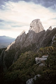
Bechervaise Plateau is actually an undulating, partly open moor surrounded by mountains and scrubby forest. But all is overpowered by the presence of Federation’s north-east face – a bulging, misshapen forehead of rock jutting 350 metres straight up from the plateau, and towering massively above us. Our relief at getting there is muted by Federation’s stunning physical presence. It is too close for good photographs, yet still forbiddingly far above us.
At a far more prosaic level, we’re also slightly miffed to find all the good tent sites taken. At least we know it’s Ray and his party, who have been a day ahead of us the whole way up. We drop our packs and slump beside them to rest and drink. When we eventually recover enough to look for alternative tent sites, we hear voices from high above. We pick out the very familiar two-noted “Awww Oy” call from Ray. He’s shouting out to us from the summit. They’ve made it! Ray is in his 70s, and has been trying to get to the top of Federation for nearly a decade. Three or four times unfavourable weather or injuries in his group have turned him back. At last this tenacious and legendary bushwalker, my first walking mentor in Tasmania, has achieved the best of summits. We are thrilled at his success, and yell our congratulations on high. We follow up with the question “How long?”, meaning how long has it taken them from Bechervaise to the summit. After much miss-hearing and repetition, we think they are telling us “Four hours!”
I can’t believe he was thinking it possible, but after the exchange finishes, Jim says to us “that’s four hours up, maybe three hours back … which makes it a bit too late for us to try and reach the top this arvo’.” We consider it for a minute. If we leave now we wouldn’t be back till at least 10. Dusk lasts well past 9pm, and the weather is clear and calm. But that could leave perhaps an hour’s descent in the growing dark, not a good mixture on an unknown mountain. When we add to that Jim’s fall and the physical efforts of the day to this point, it’s clear that we should stay put. We return to looking for tent sites, although the summit is still very much on our minds. Every now and then we hear one of the summiting party. They’re really enjoying being up there, but eventually they leave the top and start descending on the far side of the mountain, mostly out of earshot, if not out of mind. Bill finally articulates what a few of us are thinking: “Good old Ray. Ya know if he can make it at his age, and his whole party with him, then we’ve got no excuses.” I doubt that we need any more motivation, but if we do, there it is. We know most of those in Ray’s party, and while some are excellent walkers, some are having their first foray into the south-west, and one or two – including Ray – are far from spring chickens.
We have to place the tents a fair distance apart, and even then they’re on lumpy or wet sites: beggars can’t be choosers. After the tents, the “kitchen” and a hot cuppa are the next priority. The weather is sublime, sunny with high cirrus in a blue sky. We relax and enjoy the afternoon, sharing the chocolate around, resting bones and backs weary from two hard days, and minds wary of a harder day to come. A couple of us even take out books, although the occasional biting march fly keeps us from totally relaxing. When Jim jumps up with a sudden “ooh”, we wonder what’s bitten him. But instead he rifles through his pack, triumphantly bringing out a strange looking brown pouch. It turns out to be an old style wine bladder filled with vintage port. Jim assures us it’s an authentic Spanish wineskin, made of leather, “as used by shepherds in the Pyrenees”. It’s a very welcome bonus, and a few of us agree to help lighten Jim’s load. We’re near the end of a warming drop when we again hear voices – this time much closer. It’s Joe and one or two others from Ray’s party, back from the summit.
Before long we all get together to hear the full story. Like two packs of related dogs we’re excited, eager to share news, and just slightly diffident with each other. We find out that we’ve misunderstood their shout from the summit. They meant four hours return – Bechervaise to Federation. Jim and I exchange “we could’ve done it” type glances before switching to the weather. We ask Ray what he thinks it will do, and the notoriously optimistic walker, who uses a dangling handkerchief as often as a barometer to predict the weather, shakes his head doubtfully. “Cirrus comes before a change … a front’ll probably come through early tomorrow.” We brush his prediction off, and end our time together with hearty congratulations all ‘round. But the weather is uppermost in our thoughts as we go to our tents that night.
8) Bechervaise
Bechervaise Plateau, Wednesday February 6th, 1991
Bechervaise Plateau is actually an undulating, partly open moor surrounded by mountains and scrubby forest. But all is overpowered by the presence of Federation’s north-east face – a bulging, misshapen forehead of rock jutting 350 metres straight up from the plateau, and towering massively above us. Our relief at getting there is muted by Federation’s stunning physical presence. It is too close for good photographs, yet still forbiddingly far above us.
At a far more prosaic level, we’re also slightly miffed to find all the good tent sites taken. At least we know it’s Ray and his party, who have been a day ahead of us the whole way up. We drop our packs and slump beside them to rest and drink. When we eventually recover enough to look for alternative tent sites, we hear voices from high above. We pick out the very familiar two-noted “Awww Oy” call from Ray. He’s shouting out to us from the summit. They’ve made it! Ray is in his 70s, and has been trying to get to the top of Federation for nearly a decade. Three or four times unfavourable weather or injuries in his group have turned him back. At last this tenacious and legendary bushwalker, my first walking mentor in Tasmania, has achieved the best of summits. We are thrilled at his success, and yell our congratulations on high. We follow up with the question “How long?”, meaning how long has it taken them from Bechervaise to the summit. After much miss-hearing and repetition, we think they are telling us “Four hours!”
I can’t believe he was thinking it possible, but after the exchange finishes, Jim says to us “that’s four hours up, maybe three hours back … which makes it a bit too late for us to try and reach the top this arvo’.” We consider it for a minute. If we leave now we wouldn’t be back till at least 10. Dusk lasts well past 9pm, and the weather is clear and calm. But that could leave perhaps an hour’s descent in the growing dark, not a good mixture on an unknown mountain. When we add to that Jim’s fall and the physical efforts of the day to this point, it’s clear that we should stay put. We return to looking for tent sites, although the summit is still very much on our minds. Every now and then we hear one of the summiting party. They’re really enjoying being up there, but eventually they leave the top and start descending on the far side of the mountain, mostly out of earshot, if not out of mind. Bill finally articulates what a few of us are thinking: “Good old Ray. Ya know if he can make it at his age, and his whole party with him, then we’ve got no excuses.” I doubt that we need any more motivation, but if we do, there it is. We know most of those in Ray’s party, and while some are excellent walkers, some are having their first foray into the south-west, and one or two – including Ray – are far from spring chickens.
We have to place the tents a fair distance apart, and even then they’re on lumpy or wet sites: beggars can’t be choosers. After the tents, the “kitchen” and a hot cuppa are the next priority. The weather is sublime, sunny with high cirrus in a blue sky. We relax and enjoy the afternoon, sharing the chocolate around, resting bones and backs weary from two hard days, and minds wary of a harder day to come. A couple of us even take out books, although the occasional biting march fly keeps us from totally relaxing. When Jim jumps up with a sudden “ooh”, we wonder what’s bitten him. But instead he rifles through his pack, triumphantly bringing out a strange looking brown pouch. It turns out to be an old style wine bladder filled with vintage port. Jim assures us it’s an authentic Spanish wineskin, made of leather, “as used by shepherds in the Pyrenees”. It’s a very welcome bonus, and a few of us agree to help lighten Jim’s load. We’re near the end of a warming drop when we again hear voices – this time much closer. It’s Joe and one or two others from Ray’s party, back from the summit.
Before long we all get together to hear the full story. Like two packs of related dogs we’re excited, eager to share news, and just slightly diffident with each other. We find out that we’ve misunderstood their shout from the summit. They meant four hours return – Bechervaise to Federation. Jim and I exchange “we could’ve done it” type glances before switching to the weather. We ask Ray what he thinks it will do, and the notoriously optimistic walker, who uses a dangling handkerchief as often as a barometer to predict the weather, shakes his head doubtfully. “Cirrus comes before a change … a front’ll probably come through early tomorrow.” We brush his prediction off, and end our time together with hearty congratulations all ‘round. But the weather is uppermost in our thoughts as we go to our tents that night.
Federation Peak - Part 7
[part 7 of a 15 part series describing an ascent of Tasmania's Federation Peak]
7) Moss Ridge Real
Moss Ridge, Wednesday February 6th, 1991
Does the weather matter today? We’ll be slogging uphill all day on the south-west’s equivalent of the Kokoda Trail. Can it be any more challenging even if it rains, hails or snows? We’ve heard no tales of death on Moss Ridge, but every other kind of bushwalking horror story seems to have been attached to this steep ridge of clay, mud, rock and roots. “Hanrahan” is only the latest to add a tincture of doom to this place and this day.
But the weather is clear and mainly sunny, and we wave an early farewell to “Hanrahan”, who can’t resist a few final words of woe. They’re rather addled, something about the weather being fine now, “but a crocodile smiles before he eats you!” Thus comforted we shrug our packs back into the grooves they’ve made and immediately enter the jungle gym that is Moss Ridge.
To be honest this is the day I have feared the most. We have carried a rope as insurance following stories of crumbling mud cliffs, and steep four-limbed scrambling. We’ve been advised that we may need to climb some sections without packs, and use the rope to hoist the packs. Some of us have pack-hauled on a previous trip in the south-west’s Anne Range. On that occasion one or two of us had climbed up the notorious “slot” on Mt Lot without packs. Those below had then tied packs to the rope and we’d hauled the gear up the cliff one piece at a time. Finally we’d helped the other climbers up, with the rope as a safety line. Here on Moss Ridge our progress feels slow enough without the added bother of pack-hauling, so I stubbornly climb with my pack on. The snag with this ploy is that I reach the tops first, and for a time I become the chief pack-hauler. It is exhausting work. As well as hauling we are sometimes crawling uphill, scraping beneath stubborn branches of horizontal scrub, bauera and ti-tree; unhitching our packs, our limbs, our very heads from the ensnaring scrub through sheer brute force. “Do that for a few hours and a quiet death in the snow starts to look appealing” one advisor had cheerily opined.
In the midst of these trials, Jim suddenly slips on a mud-slimed rock and falls heavily. He lands chest-first on a protruding tree root, the full weight of his pack on top of him. Grunting with pain, he rolls over, and lies there stunned and winded. We help him get his pack off and sit him up to assess the injury. With the wind knocked out of him, Jim initially can’t speak. As he begins to recover we can’t help noting what an unusual phenomenon that is. Jim laughs, and grabs his chest in fresh pain. He’s fallen on his ribs, one of which is particularly agonising to the touch. The Doc – actually a gynaecologist – checks him out, and simply suggests a rest and a bit of water. He quietly adds that he’d probably be a bit more help if it was a breach presentation. After another painful laugh and several minutes of rest Jim starts to feel slightly better. We discuss his state with him, and he reckons he’ll be okay to go on. Only after the trip does Jim confirm that he’s cracked a rib. But by then it is a war wound to brag about rather than a trip-threatening injury. At the time the only alternative to going on is going back. Given that it’ll hurt either way, Jim opts to go on, and we acquiesce. In hindsight it was a brave call, but at the time we’d never have told Jim that! Instead we struggle on, keeping half an eye on Jim. We also look out for some small tent-sites that are supposedly hacked into the thick scrub part way up the ridge, in case we need to stop early for Jim.
Between these distractions and those of the on-going obstacle course, we’re surprised to find Moss Ridge beginning to level out. We’re almost at Bechervaise Plateau, our destination for the day. Despite the terrain and the mishap, we’ve only taken 6 hours, and it is still just mid afternoon.
Sunday, 19 July 2009
Federation Peak - Part 6
[part 6 of a 15 part series describing an ascent of Tasmania's Federation Peak]
6) To Cutting Camp
Cracroft Valley to Cutting Camp, Tuesday February 5th, 1991
After crossing the South Cracroft River, we climb over a spur and head towards the West Cracroft. When lifting cloud and obstructing vegetation allow, we see views of the Eastern Arthur Range, and even of Federation. We are slowly drawing closer. The going is relatively easy, but we have first-day aches all over our bodies, and our rate of stumbling is increasing. Bill falls yet again, managing to add another cut to his already impressive array of bleeds. The leeches like him too, and we’re soon dubbing him “the little Aussie Bleeder”. He just grins and says “to be sure!”
Track notes and reports of previous trips tell us there are a couple of campsites along the West Cracroft. But on the ground it’s not always easy to tell. Somewhere we pass what’s grandly called the Victorian Mountain Tramping Club (VMTC) campsite. Perhaps we are too tired to notice it; perhaps scrub regrowth has begun to disguise it; or possibly our map has it marked inaccurately. Later we realise that it’s beside the old track, which our new route only rejoins just west of the VMTC camp. But that afternoon we are befuddled, and finding the Paperbark Camp only compounds our confusion. We think it’s the VMTC camp, and that Paperbark Camp – which some of us favour as a potential stop before Cutting Camp – is still ahead. So we push through our fatigue and walk on.
After around 11 hours on the track, we stumble at last into the next obvious campsite. It’s cut out of deep forest at the foot of a ridge, and if it’s Paperbark Camp it’s strangely named, as there’s not a paperbark in sight. It takes the appearance of another walker from his tent to confirm that we’ve actually reached Cutting Camp. This is a hard-won kilometre further on than we thought we’d come. It’s undoubtedly good news, but we’re too tired to even feign celebration.
The walker turns out to be a strange and eccentric character: an obvious novice who still manages to be highly opinionated. He swarms all over us, as far as it’s possible for one individual to swarm, volunteering that he’s from Victoria, is travelling alone, and is on his way back from an unsuccessful attempt to climb Federation. We swiftly come to understand why he walks alone as he blurts out every unfortunate detail of his terrible adventure so far. We’re far too weary to hear this now, but also too tired to fend him off. Dressed in cotton army surplus gear unsuited to the conditions, bedraggled and only semi-lucid, he’s like a ship-wrecked sailor who’s seen a ghost. He has nought but tales of woe from the heights above; how his tent blew down, how he almost blew down, and how “mate … you don’t want to go up there. It’ll rain an’ hail an’ sleet an’ snow an’ blow a gale, and yer all gunna die” or words to that effect.
We eventually make our excuses and withdraw to put up our tents; not all of them are as far from our strange comanion as we’d like. Thankfully he disappears as we get together over a hastily-prepared meal. In soft-voiced conversations we can barely stifle incredulous laughter. We agree we’ll have to call him “Hanrahan”, after the pessimistic character in John O’Brien’s poem who keeps proclaiming “we’ll all be rooned”. Just before we retire for the night he returns for an encore, bearing a hard-cover reference book to show us where we shouldn’t be going “if yer value yer lives!” The book is Ken Collins’ lovely “South West Tasmania” book. But “Hanrahan” hasn’t been kind to it, and the sodden book has swelled to the size of the “Lord of the Rings”. It must weigh a kilogram!
Federation Peak - Part 5
[part 5 of a 15 part series describing an ascent of Tasmania's Federation Peak]
5) Passing Wargata Mina
Farmhouse Creek to the South Cracroft, Tuesday February 5th, 1991
To the left is the indistinct track to Lake Sydney, a remote glacial lake cupped between Mt Bobs and The Boomerang. I passed that way another day, and got close enough to a platypus to hear it breathe. But on this day we go straight ahead, up and over the lushly forested saddle, and on towards Federation. In the distance some currawongs send out their claxon call, to me the signature sound of the highlands. Immense King Billy pines, metres in circumference, deep green with deeply furrowed trunks, guard the track. They are ancient outposts of Gondwana, common here in the high rainfall high forest, but increasingly rare in the drying climate that begins to take hold even here in southwest Tasmania.
From the saddle the track has been re-routed, out of respect for other ancients – Tasmania’s Palawa. Aboriginals lived here thousands of years before Abraham or the pyramids, and they left hand stencils at Wargata Mina, a cave west of here. At the request of their descendants the track, which once went by the cave, has been re-aligned to give the sacred site wide berth. It is now one of the few pieces of land under direct Aboriginal control.
Over lunch – mine a squashed but still-fresh bread roll from home – I think about Aboriginal presence in this area. To our group this is wilderness, the Tasmanian Wilderness World Heritage Area. But to those who left hand stencils in Wargata Mina over 10 000 years ago; who spat paint against outstretched hands in the deep dark, it was home. They and their descendants have walked and worked this land ever since. The extensive areas of buttongrass are partly a result of Aboriginal burning, and some of the tracks they used have become the tracks we use.
But not the new section of track beyond the saddle at the top of Farmhouse Creek. We’re among the first to use it, and we make rapid progress down the slope towards the South Cracroft River. As it flattens out the track moves out of forest into more open heath. It looks to have been hastily cleared, with the stumps of felled paperbark, ti-tree and bauera protruding everywhere, and some of the cut foliage still strewn about among the buttongrass. We adopt a four wheel drive-like gait, lifting our legs high to prevent us tripping on the low stumps. The literal downside of this is that we’re more prone to slip on the almost grassy, sometimes mossy surface. At least with so few feet having gone before us, there is mercifullly little of the usual southwest mud to mark our occasional falls. It also helps that the threatened rain has been little more than a thin drizzle. And not long after we cross the South Cracroft, we even begin to see Federation Peak – a cloud-shrouded giant looming before us.
Federation Peak - Part 4
[part 4 of a 15 part series describing an ascent of Tasmania's Federation Peak]
4) Up the Creek
Farmhouse Creek, Tuesday February 5th, 1991
I get busy putting on my boots, tying, testing, undoing, re-tying. I repack my pack, making sure that comfort foods are near the top. It is all distraction and delay. Jim starts ribbing Bill, whose walking attire is far from glamorous. I recall that Bill was the fall-guy on a previous walk. He slips comfortably into role, beaming idiotically, coming back at Jim in a faux-Irish accent which I instantly pick up. The banter helps settle the nerves, and next thing the heavy packs are hoisted and we’re walking into the still, damp and lusciously green forest, uphill of course.
In truth “green” is a vastly oversimplified descriptor for the forest. There are mosses and leaves of almost fluorescent green; there are sombre olives, glaucous blue-greens, lively gold-tinged greens and deep sea greens. The hue is not just on the forest floor or in the leaves of the tree-tops, it is there at every level, from roots to trunks to branches to fungi. The very air has a greenish tinge. And then there are the browns, more browns than the largest Cumberland pencil set could have names for; from the whisky dark of the creek water to the club chocolate of the muddy track, which colours Bill’s shorts after his first slip on a tree root.
Within 15 minutes we’re all very much aware of our legs, our lungs and our backs, and in another 5, when somebody calls out for a break there is no voice of dissent. With exertion the banter has trailed off, and we’ve heard only the thud of bootsteps, the grunt of pack adjustments and the ragged gasps of our own breathing, broken occasionally by the call of a crescent honey-eater egypt ee-gypt or a golden whistler we-we-we-tu-whit. In the forest only the voices distinguish the otherwise hidden birds.
Over the two previous springs, we’ve had a golden whistler challenging its own reflection in our lounge room window. He would fly at the window, turning at the last minute to dash his feet against the pane. Next he would hover as best he could, repeatedly pecking at the glass in an effort to drive off his opponent. He’d then retreat to a nearby limb to regain his strength before returning for another round against this doughty foe. Of course his opponent was his perfect match, so despite hours of effort, victory was never possible. I think I lost interest before he did, but it must have been the same poor creature who returned at the same time the following year, and repeated the whole fruitless exercise all over again. As I trudge up the Farmhouse Creek track, it doesn’t occur to me to compare myself with this bird. But who am I challenging if it isn’t myself?
Federation Peak - Part 3
[part 3 of a 15 part series describing an ascent of Tasmania's Federation Peak]
3) To Farmhouse Creek
The Southern Forests, Tuesday February 5th, 1991
We end up with a group of seven, ‘though we’re more proficient than magnificent. Jim, Bill, the Doc and I have all walked together in Tassie before, but none of us is exactly a “gun” walker. Margaret, a friend of a friend, also has a bit of Tasmanian experience, but Peter and his daughter Natalie, from Western Australia, have limited experience. For all of us this is by far the hardest walk we’ve ever attempted.
We’ve chosen to approach the mountain via Moss Ridge, in turn accessed via Farmhouse Creek. The scene of fierce anti-logging protests in the late 1980s, Farmhouse Creek still has something of an iconic status just a few years later. The road to Farmhouse Creek slashes into the southern forests, beyond the Picton River, and deep into areas that by any assessment deserve World Heritage Area status as much as the neighbouring areas that have that designation. The view from the top of nearby World Heritage listed Hartz Peak tells this story very plainly. To the west and south are wildly folded mountains variously covered in forest or moorland, with no roads and no access other than on foot. To the north and north-west, where roads and their accompanying machines have been, wildness is replaced by the ugly scars of the clear-felling of ancient forest. It is work of which Saruman would be proud.
Controversy is fresh enough that we have to check with the Forestry Commission to be sure the bridge over the Picton River is open to the public. Last season it was closed “for safety reasons”, and friends were forced to walk an extra day through logging coupes. Driving through these clear-felled areas is distressing enough; to walk it would be heart-breaking.
But at Farmhouse Creek the chopping stops. A small sign says we’re in the Tasmanian Wilderness World Heritage Area. It is still and deeply quiet after the jolting drive. My stomach is less than happy, partly from the drive, partly from apprehension. Will I manage the walk? What about the climb? Is my pack too heavy; my food adequate; my clothes suitable? Will the weather hold out? Will I slow everyone down? A thousand insecurities bred of the self-doubt that accompanies unemployment.
The sky is a cheerless grey, the air chill. It’s the kind of cool that clings in these shady valleys even on warm days. Today it is reasserting itself fully against a fickle summer, spreading out into the forested ridges that stretch far above us. Had it been a fine day, we wouldn’t have seen the mountains until a few hours into the walk. But hours could become days if this weather translates into the wet and cold that so often prevail around the Arthur Ranges.
Federation Peak - Part 2
[part 2 of a 15 part series describing an ascent of Tasmania's Federation Peak]
2) A Cautionary Tale
Hobart, late January 1991
Ever careful with his preparation, Jim has found out that his friend, Alderman Rob Valentine*, went to Federation in the early 80s. So we’re all at Jim’s place for a briefing on the climb from Rob. His account is calm, methodical, and shocking. The party he’s with has reached Lower Bechervaise Plateau via Moss Ridge a couple of days ahead of another group approaching the mountain from the Thwaites Plateau route. Rob & co. have had a rough trip up Moss Ridge in very hot weather. Their exhaustion is compounded by dehydration, and they decide to have a lay day in order to recuperate.
So it’s the following day, rested and ready, that they finally – and successfully – climb the peak. They are back at Bechervaise campsite in the late afternoon when they hear the yahooing of the following group, more than three hundred vertical metres above them. It is, they guess, the sound of a successful summit climb. Some time later they hear more yelling, and assume it is simply more summit shenanigans. After returning to Hobart they are shocked to learn from the television news that they’ve actually heard the scream of a fatal fall. Two walkers have been climbing as part of a larger party coming up from Thwaites Plateau. They have reached the top, and on their way down one has successfully negotiated a nasty part of the descent just below the summit. She waits below for the other, the next to descend, encouraging him with comments on how his longer legs are making it easier for him. But then, momentarily forgetting where she is standing, the first walker has stepped backwards into thin air. She has fallen more than 100 metres off the southern face of Federation Peak to her death. Her companions have screamed in horror and disbelief – apparently the sound that Rob’s party have heard. At the site of the fall, Rob reminds us, the total exposure is some 600 metres to Lake Geeves below.
We listen with horrified curiosity, and a rapidly growing doubt about the wisdom of our whole venture. The knot in my stomach leaves no room for the supper Cheryl brings out at this point. To be fair to Rob, he hasn’t come here to scare us. In some ways he’s encouraged us with his self-disparaging account of his own summit success. He implies that if a less-than-athletic man such as himself can do it, we should have no worries. We mutter half-hearted agreement, ask about some track and navigation issues, and politely shuffle bits of cheese and dip around the plates. But what I take from that night are the scream and the fall. And they stay with me over the coming weeks.
* My thanks to Rob Valentine, former Lord Mayor of Hobart, for his assistance with this section of the story.
Federation Peak - Part 1
[part 1 of a 15 part series describing an ascent of Tasmania's Federation Peak]
1) A Mountain on My Mind
Hobart, Tasmania, January 1991
Tasmania’s Federation Peak lurks at the back of every Australian bushwalker’s mind. It is the mecca, the holiest-of-holies for those who seek for what is high, wild and scarce in our otherwise wide brown land. In my case Federation even sits, icon-like, at the side of my desk in the form of Jim England's 1980-something black and white aerial photograph. A sign and symbol of Tasmania’s south-west wilderness, a shrine that draws my mind to those special mountain realms during moments of reflection or distraction.
But holy or not, I know there’s a difference between shrine and reality. I am unlikely ever to experience the real city of Mecca. But I have no doubt that my level of preparation, the company in which I travel, the time taken to get there, the smells, the sounds, the weather; the time of day, the state of my gut and the frame of my mind; all of these would colour my actual experience. It is a pilgrimage whose outcomes are not always those expected or desired. It is not to be taken lightly.
Nor is Federation Peak. It is a serious mountain by Australian standards, a mountain which has claimed lives. Climbing it takes careful mental and physical preparation. After more than a decade of walking in Tasmania, it is one walk for which I am still not ready, even in my late thirties. No, if ever I am to walk to Federation Peak, if ever I negotiate that final massive fang of rock, it will only be when I am considerably fitter and better prepared than I am now. It will have to remain the mountain at the back of my mind.
But then my mate Jim rings proposing a trip to Federation. I am an unemployed husband and father of three young children. That has brought plenty of fears and challenges of its own, but Federation Peak? That is another beast altogether; one quite beyond my current strength. I mutter something about needing years – or at least months – of mental and physical preparation. But Jim isn’t really listening. He says we have the chance now, and as I’m on the “long holiday” of the unemployed, he won’t accept any excuses. I somehow find myself agreeing to go. It only hits me later that we leave early next month. Immediately a knot begins to form in my gut.
Thursday, 16 July 2009
Habitat Garden: Chapter 1
[excerpt from my book "Habitat Garden" ABC Books, 2003]

Photo: Little Wattlebird on a grevillea bush
Everything lives in a habitat. Whether it’s a rat up a drain or an earwig in a corn stalk, all living things – humans included – depend on a complex network of other living things, as well as air, water, earth, sunlight and shelter.
Yet most humans live in a highly modified habitat. We can spend all day in a building with artificial light and air conditioning. We can travel inside vehicles, eat packaged food and amuse ourselves with electronic gadgetry. We can sometimes forget that there’s an outside world, or can even begin to think that we aren’t a part of the natural environment.
Gardens have long reminded us that we are part of life on earth. A garden can help reconnect us with the soil, the air, the sun and the rain that are essential to all life on earth – including our own. In the truest sense gardening is a recreation.
This is a book about reclaiming our connection with the environment – starting literally in our own backyards. Every backyard is part of the larger environment, and every backyard provides a habitat – a particular native environment – for something, whether we like it or not.
Even a concrete balcony may provide a suitable environment for, say, algae or spiders. So if they’re coming anyway, why shouldn’t we get involved in choosing what comes to our backyard to live or visit?
What is a Habitat Garden?
A habitat garden is simply a garden that attempts to favour certain types of spaces for certain types of plants, animals, insects and other life forms. In Australia that means a garden that favours Australian native plants over plants from other countries, and Australian life-forms and communities over those from any other place. More than that a habitat garden favours local plants and local communities over those from anywhere else.
Habitats are complex things, involving an intricate interconnection of everything from bacteria, bugs and rocks to sunshine, water and temperature. No-one should pretend that they are going to be able to recreate a complete and wholesome natural habitat in the average backyard. But a habitat garden can start to recreate some of the spaces that we’ve squeezed out of our local environments in recent years.
Why Habitat Gardens?
Few things are as rewarding as getting to know your local flora and fauna. To sit at a window and watch a honeyeater hovering over a grevillea that you’ve planted, or to wander in your garden and spot a bandicoot sneaking back under a bush – these are some of the enduring pleasures that can be part of every habitat gardener’s day.
And the opportunity to watch the changes that come with the seasons; the effect of good rains; the blossoming of wattle; the first flight of newly-winged cicadas; or the return of migratory birds: such are the subtle pleasures of garden life in our marvellously varied country.
But there’s more than personal pleasure involved. Have you looked around suburbia lately? Have you been out in the bush that you used to play in as a child? More and more of our country is being covered by concrete and housing developments; roads and shopping malls. Most of the bush that gets used in this way ends up being alienated from its natural inhabitants – if it isn’t destroyed totally. The environment that had supported a vastly complex web of plants and animals ends up being simplified for our use, often with no thought of what becomes of the other life forms that used to call it home.
But it doesn’t have to be that way. The kinds of alterations to the natural environment that we call development can – and sometimes do – carefully take into account its natural inhabitants. Housing or industrial developments can be designed with habitat preservation in mind.
Even in established housing areas, habitat gardening is one way we can play a small part in restoring our environment. With Australia one of the driest countries on Earth, with generally shallow, nutrient-poor soils, our gardening style can have a significant impact on the environment – for good or ill. If we persist with gardening styles that are based on the cooler, wetter climates of places like Europe, we can only do so if we use enormous amounts of water and artificial nutrient. This uses up not only personal energy but also precious natural resources. Habitat gardening offers the chance to find a gardening style that’s better suited to our climate.
Another argument relates to the sobering fact that since European take-over, Australia’s native plants and animals have become rare or extinct at a higher rate than almost anywhere else on Earth. We’ve introduced hard-hoofed animals such as sheep and cattle that graze and trample in ways that native animals don’t. Add to that the plant and insect pests that we’ve let loose all over the country, and it’s plain that we’ve drastically changed our natural environment. Put simply we’ve shrunk the habitats available for our native plants and animals.
Of course we have a wonderful array of national parks and other reserves which provide havens for some of our flora and fauna. But such reserves only cover about 6% of our land area. And often national parks are on land that was otherwise considered marginal for productive purposes. Because they do not represent the full spectrum of ecosystems, reserves alone can never provide enough habitat for healthy populations of the amazing diversity of life that calls Australia home.
What’s needed is a popular movement among land-holders of all sorts, even suburban ones. It’s a movement that aims to retain the wonderful range of unique species – the biodiversity – of our island continent.
We already see vast tree planting and bush regeneration efforts from governments as well as from local groups and organisations such as Bushcare, Landcare and Greening Australia. And individual farmers and farming organisations all over Australia are also making huge efforts. Habitat gardening brings people power to home gardening. It is the next wave – the green revolution brought into the humble backyards of Australia.
It has a modest but potentially profound aim: to try and win back some space in our backyards for the disappearing Australians – our local native plants and animals. The aim of this book is to help you – wherever you are in Australia – to design and grow your own habitat garden so that you too can contribute to this down-to-earth revolution.
Wednesday, 15 July 2009
First Steps
[draft introduction to forthcoming book about walking]

Photo: Resting on Mt Oakleigh, Tasmania
I have no memory of my first steps. But my first recollection of childhood has me walking in a garden. I amble between rows of gladioli, their flowers towering above me like wonky trumpets. There is a rich organic smell from my father’s home-made compost. I cannot have been much more than 2 years old.
Anyone who has witnessed a child on the verge of walking will appreciate what a perilous act it is. What skill and will is required to prevent our pumpkin-weighted, top-heavy heads from bringing us smashing back to earth. Two-footed walking is the constant prevention of toppling by the placing of one foot in front of the other. Only familiarity and continual practice disguise its wonder: that and the fact that most of us have more or less mastered the art to a basic degree. Few primates and even fewer other mammals can boast as much.
I was born in the afterglow of Sir Edmund Hillary and Tenzing Norgay’s successful ascent of Mt Everest. Common or garden walking – the same sort by which I had negotiated my way through the gladioli – had taken them to the top of the highest mountain on our planet. As a child of that time, it meant that anything seemed possible, if only I kept at it.
But there were other events, both global and familial, that meant I didn’t take for granted that my legs would always work. The same year Hillary and Tenzing reached the top of the world, around 10 000 people in Australia contracted Poliomyelitis. The disease killed more than a hundred of those, and left thousands unable to walk. My great uncle Gwesyn was one of them.
For many years his presence, metaphorically more than physically, was a powerful and fearful one for me. On Sundays our family would sometimes visit Gwesyn and his sisters, my fraternal grandmother and my great aunt. But we would seldom see any more hint of great uncle Gwesyn than a wheelchair or discarded walking cane in the darkened hallway.
On rare occasions we would hear his voice from the end room. It added a frisson of excitement to the atmosphere of drawn curtains, whispered conversation, doilies and polite cups of tea at Grandma’s. For some reason, it could have been fear or shame, but was more probably a misguided desire to “protect” us from his suffering, it was many years before we properly met Uncle Gwesyn.
Whispered conversations seemed a standard part of our family life, especially when it came to health and money. I knew the meaning of sotto voce before I wore long trousers. There was secrecy about my mother’s kidney disease and my father’s pleurisy, both potentially life-threatening. Being unable to discuss such things openly, we developed an unhealthy fascination with health matters. My older sister dabbled in hypochondria, faking her own appendicitis so expertly that she had the perfectly healthy appendix removed.
In my own case I developed what was apparently known as hysterical paralysis. For a day or two my legs simply refused to work, locking up and causing me to stay in bed until our doctor friend – in a whispered aside – told my parents it was nothing to be worried about. A few promises of treats and a bit of jollying along soon got me walking again. But to this day I wonder whether it was a phantom paralysis brought on by a morbid fear of Uncle Gwesyn’s polio. Though he became so much more, during those formative years he was a powerful reminder to me that walking was a gift to be cherished.
And if I could walk, I desired to walk among mountains. From my childhood home in Sydney’s inner north we looked across bush towards the distant Blue Mountains. On clear days, with a westerly wind sweeping haze from the air, the plateau formed a blue margin between bush and sky. The bulk of Mt Tomah – how important it always seemed to know a mountain’s name – would sometimes be enhanced by an afternoon build up of white storm clouds. If I squinted the clouds became snow-capped peaks above the blue foothills of a Himalayan range. Starved of true mountains, these were the mountains of my mind.
One Sunday afternoon I had my first chance to ascend this squinty mountain range. Even aged seven or so I understood that a picnic with your family, including a grandmother and a couple of elderly aunts, was not the standard build-up to a climb. But armed with my father’s word that “the Blue Mountains proper begin when you cross the Nepean River”, I knew what I had to do.
While the elaborate picnic lunch on the Nepean’s banks was being packed up, I quietly slipped away. Avoiding stinging nettles and cow pats, I waded into the shallow sandy waters of the river, gasping slightly at its sudden cold. I was sensible enough to remove my sandals for the crossing, buckling them back on once I was on the far side. Then with gritty wet feet and a thumping heart, I climbed the steep bank and began my ascent of the Blue Mountains.
The climb was cruelly interrupted when one of my sisters started following me, giving the game away. With so many overly-sensible adults on the look-out, it should have been no surprise to me. But I still felt thwarted, convinced I was within reach of my goal.
Nearly half a century later, I haven’t grown out of this early love. Mountains loom larger and closer than ever. My childhood fascination has drawn me to live almost literally in the shadow of one particular mountain. Kunanyi/Mt Wellington is my muse, my barometer, the visual shelf for my half-formed thoughts. It draws the rain – God’s sprinkler we used to call it – and keeps a dogged doleritic watch over Hobart and the valleys, hills and waterways around it.
From such a base, with more than 40 years of walking behind me, it feels high time to pause and celebrate walking. I want to reflect afresh on the wonder of where feet can take you, and what you can experience along the way. In part this book is an attempt to repay a debt owed to a mountain – a mountain that became my own Everest, and made a difference to how I have faced the rest of my life. It is also an attempt to explain in words an activity undertaken by millions which consistently hovers somewhere between the ordinary and the extraordinary; the pedestrian and the celestial. What follows then is the story of one particular walk as well as an ode to the wonder of walking in general.
Across the Ditch
[excerpt from a forthcoming book]

Photo: on the Routeburn Track, NZ
For a Tasmanian, walking into a New Zealand beech forest is like finding a previously unknown relative. There is something so familiar about the colour, the feel, the look of the trees; the shape of the leaves, the damp tang, the fungi on the trunks, the texture of the forest floor, the glow of the mosses. Even some of the bird calls hook the heart toward home. These are surely some of the old trees of Gondwana, just like those I’d find if I crossed Cephissus Creek and walked up that ever so familiar track towards Pine Valley Hut in central Tasmania. Just like those I’d find in whole swathes of Tasmanian forest which continue to resist the almost irresistible advance of the eucalypt.
And of course the resemblance is a family resemblance. The various species of Nothofagus (literally “false beech”) are found in New Zealand, Australia, South America, New Guinea and New Caledonia. Its distribution was one of the keys to the theory of continental drift. Because Nothofagus seeds aren’t dispersed by birds and other animals, and don’t spread far in water or wind, it seemed highly unlikely that the current distribution happened across the oceans. Rather, it is now accepted, these landmasses were conjoined until their diaspora began around 80 million years ago. By that time the ancestors of the beech genus were established, and when Gondwana split, each part carried with it a botanical, invertebrate, mycological and microbial cargo that has continued to evolve and adapt to new conditions, and to the addition of other new species.
As we walked that day through beech forest towards Rob Roy Glacier, I noticed more than just the similarities. There were also differences; some obvious and easy to spot, some more subtle and profound. Tasmania’s beech forests are not abounding in obvious wildlife. Much of it is cryptic and/or crepuscular (most active at dawn and dusk), and so not always visible when bushwalkers are out and about. But the evidence is always there if you know where to look. It might be a whiteish, fur-filled scat giving away the scavenging diet of a Tasmanian devil. It may be a tunnel-shaped runway through the understorey betraying the presence of potoroos. Or perhaps a fur mass showing where possums have had a territorial scrap. And where the margins of the forest meet buttongrass plains or heath, the comically practical cuboid scats of a wombat are rather more obvious, deftly deposited on logs or rocks or tracks for other wombats to read.
In this New Zealand beech forest, the first thing I noticed was the lack of these signs, and thus the lack of mammals. Of course I knew that New Zealand didn’t have any native land mammals, and that this was another Gondwana-related matter. Although ancestral marsupial mammals had been in Gondwana before New Zealand broke away, none had survived in modern New Zealand (no-one knows why). So I expected no scats, no runways, no fur scraps. But it was still more than strange to think of a forest without native mammals, even at night.
Then a most remarkable creature began to turn my thoughts around. In the middle of the beech forest we quite abruptly came upon our first kea. Thinking it would be shy and soon fly off, we cautiously took out our cameras. Keeping a respectful distance, we took some photographs, the large sickle-beaked parrot patiently posing for us. But as we put our cameras away and continued our walk, the kea hopped nonchalantly onto the path and began to follow us. Photo: Kea near Rob Roy Glacier, NZ
For a good hundred and fifty metres, we were tailed by this lord of the forest, hopping along the track like a green ghost of Long John Silver’s parrot. When we stopped, the kea stopped; when we moved on, so did the kea. It was as comfortable and confident as any Alaskan brown bear would have been in the forests of Baranof Island, where we’d walked just a year before. But I’d have to say I was a lot more comfortable being followed by a giant parrot than a giant bear!
In a strange way the comparison is not completely odious. In the absence of terrestrial mammals, the New Zealand food-chain is topped by birds and reptiles. In a real sense the kea is one of the kings of the bush in New Zealand – so much so that a bounty was once put on their heads because of the mayhem they can create among remote sheep herds. They will eat meat, especially seeking the kind of high-energy fat that will keep them going through the winter. The bounty system, which saw perhaps 150 000 keas destroyed, was ended in 1971, but the species was only legally protected as late as 1986. Today its range is far more restricted than it once was – largely due to human persecution. However its presence, perhaps even its place of honour, in the South Island’s high country forests, seems secure.
This ecological niche-shifting – at least in comparison with the hierarchies I’m familiar with – was further illustrated as we walked along the West Matukituki River. Pied oystercatchers (Haemotopus ostralegus) are common in Tasmania, as they are in many parts of the world. At home they are almost entirely coastal birds, partially living up to their name by feeding on molluscs, crustaceans, worms and other seaside treasures found on beaches. They breed along those same beaches. But in New Zealand, perhaps because mammalian competition and predation is minimal, these oystercatchers mostly breed along the braided rivers of the South Island. The changeable but fast-flowing inland rivers must create similar conditions to saltwater tides, stirring up sediments, creating water and air movements that encourage edible invertebrate life. Certainly the equally incongruous presence of terns and gulls along these rivers points in that direction.
Regardless, hearing the oystercatcher’s startled wik wik cry, so familiar from my Tasmanian coastal walking, still caused a double-take here by the Matukituki. It was like hearing a rooster in a restaurant: a normal enough sound in an altogether unexpected place. The restaurant analogy was once sadly apt, as these New Zealand oystercatchers were hunted as gamebirds until protected in 1940. Apparently no-one told Tasmanians, as I’ve not heard of them being eaten in my home state. But this particular day, along the beautiful Matukituki, they seemed perfectly at home, foraging by the river or prodding sods for a morsel. It’s good to hear that their numbers are increasing now that hunting has ceased.
Taking the long view, it’s harder to be optimistic about the many other kinds of change that human action continues to bring into all of the world’s ecosystems. We may no longer hunt down keas, oystercatchers and Tasmanian devils, but they – and we – are slowly being hunted down by that 21st century scourge – climate change. In Tasmania, for instance, the advance of the eucalypt, so brilliantly adapted to drought and fire, will sooner or later displace the old Gondwanan brigade.
This was poignantly illustrated while we were tramping in the wet New Zealand spring/early summer of 2006/7. As we slopped through a very wet final day on the Routeburn Track, Tasmania and much of eastern Australia was having an early and severe bushfire season. Projected long term, for Tasmania at least, there must be concerns for the long-term survival of drought and fire-intolerant species such as many of the Gondwanan species.
Climate change predictions for Tasmania and New Zealand’s South Island may drive the former Gondwanan mates further apart. Species such as the devil, already threatened by a cancer-like plague that has seen them officially declared endangered, look far from secure in the very long-term.
In New Zealand the ongoing mayhem caused by feral animals is considerable, and no case is worse than that of the possum. The deliberate release of Australia’s much-loved brush-tailed possum (Trichosorus vulpecula) in the mid 19th century for the fur trade has had disastrous results. There are now estimated to be up to 100 million of them in New Zealand, and they’re found in virtually every part of the country. I have a vicarious sense of shame in the fact that they are dubbed “Tassie blacks” because of their fur colour and their state of origin. There is only a slight easing of that feeling when you find you can purchase gloves, thermal and fashion clothing that uses possum fur to add warmth and weather-resistance to wool. With typical Kiwi flair it’s referred to as “merino mink” – a neat marketing tag that combines wool of Spanish provenance and fur with Tasmanian origins, adds an allusion to a now-rare European fur, and somehow makes it sound 100% pure New Zealand.
Of course change will always happen, whatever effort we might make to forestall it. And there will be some winners as well as losers in the natural environment. But as I walk in these delightfully wild areas, it’s hard not to feel the sense of an old order passing.
A HEART NEEDS A HOME: Finding A New Nature Literacy For Australians
 Photo: Robert Frost's cabin, Vermont
[Paper presented to the Interpretation Australia Association conference, Alice Springs, August 2001]
Introduction
What role does the written language play in the development of attitudes toward the environment? Is it mere coincidence that Australia – with its appalling extinction and land degradation record – is a nation with low levels of nature literacy? A largely urban and coastal people, we seem happy to acquiesce to glib views about Australian nature, settling for the “wide brown land” over more nuanced understandings. Could the way we think and write about nature become a catalyst for changing our attitudes toward the environment?
European Ideals, Australian Realities
The European appropriation of Australia coincided with the Romantic Movement, a literary and artistic development that lasted from the late 18th to the mid 19th century. As the First Fleet set sail, William Wordsworth was wandering lonely as a cloud and Wolfgang Amadeus Mozart was completing Don Giovani. The ideas of the Romantic Movement grew out of revolution and nationalism, and included a strong reaction against rationalism and industrialisation. As a consequence writers and artists were drawn in a new way to nature and landscapes.
It would be easy to underestimate the impact of the Romantic artists. It is unlikely, for instance, that Wordsworth could have anticipated that his writings would lead to the establishment of national parks. Yet such a consequence can be traced from the growth in nature-consciousness – this “new” way of looking at landscape – not just in his beloved Lake District, but as far afield as the United States. Words such as sublime and picturesque were applied to landscape for the first time, and the desire to protect and preserve such places from newly rampant industrialisation grew strongly.
The Movement also effected mainland Europe. An instructive example is the establishment of an independent Norway. The Scandinavian nation’s break with first Denmark and then Sweden was very much influenced by Romantic notions. As 19th century Norwegians searched for ways of establishing their own national identity, they turned to their landscape – the mountains and fiords – to distinguish Norway from its flatter, forested neighbours. A new wave of nationalistic literature celebrated Norway’s own landscape and lore. Nationhood and nature; literature and cultural self understanding became deeply intertwined.
Meanwhile what was happening in Australia? During this same period the British were struggling simply to survive their first decades in New South Wales and Van Diemens Land. By the time they’d gained any sense of security, let alone prosperity, the Romantic Movement was already on the wane. The urge for nationalism, which might have spurred a cultural self-understanding based on our own physical environment, was past. Instead the European Australians camped on the land as exiles, attempting to assuage their homesickness by creating an antipodean England. This made them more inclined to exploit the new land than to love or understand it as it really was.
But if that boat was missed, did all chance of an environment-based self-understanding leave with it? Is there no way that we can re-invent our self-understanding so that Australia’s unique and diverse natural environment is better incorporated?
A Quest in the Romantic Tradition
In true Romantic fashion, I decided to travel to the wilder parts of the UK, Ireland and the USA seeking possible answers. Could the roots of British and American nature writing provide clues as to how Australians might grow their own nature literacy? I found much to encourage such a quest, but also cause for caution and further thought. Though my findings are selective and somewhat anaecdotal, this too seems appropriately Romantic.
In Scotland my visit to the Isle of Skye was greatly enlivened by reading the late Gaelic poet Sorley Maclean (in translation). Here was a modern poet of place, writing for and about his own small group of Scottish islands, which are dominated by the Cuillins, two prominent sets of mountains. Strikingly Maclean uses “Cuillin”, among other place names, as a metaphor for beauty. When I asked myself whether Australians would easily use a geographical point as an adjective of adoration, I could only conclude that any “Kosciuzko of my heart” would be met with derision! Yet this was the first lesson of my travels. Deep connection to place may best be expressed in language derived from the experience of that place – in short an endemic language.
While still in the highlands of Scotland I had the opportunity to canoe the Spey River with a group of Scots over several days. As we progressed from mountain to sea, I began to see and hear things that made me aware of the different ways in which Australians and Scots see the natural world. But it was a conversation with an old Scot in Grantown-on-Spey that crystallised one of the key differences for me. In explaining that he wasn’t born where he now lives, the old man said simply “I belong to Wick” (a town in the far north of Scotland). Whatever deep sense of belonging Australians may have, they would not express it in that way. I, for instance, would never say “I belong to Tasmania”. Yet many Scots that I met showed this kind of deep attachment to their town or district. And this attachment comes through in conversation, in music, in story and in the deep Scottish fascination with history. This was the second lesson: Authentic cultural expression – including a vibrant nature literacy – may need to grow out of a deep and prolonged sense of belonging to place.
This was also the first warning sign in my quest. Is there any way that such a sense of belonging can be hurried? Must white Australians inhabit this land for many more centuries before they belong? Some Indigenous Australians believe this to be the case, and certainly white Australians have much to learn from the first Australians in terms of understanding the country. At the least I see an orange light against any easily gained sense of belonging. On the other hand, who can tell the heart it doesn’t belong when that sense grows within? To quote another Scot, singer Dougie MacLean, “you can’t own the land, the land owns you”.
Ambiguities in Ireland
In Ireland there was ambiguous evidence on this issue of belonging. On the one hand I was struck by the nature writing of two expatriate Englishmen now living in the west of Ireland. There could hardly be two people more deeply immersed in place that Tim Robinson and Michael Viney. Robinson’s remarkable books about the Aran Islands – “Stones of Aran: Labyrinth” and “Stones of Aran: Pilgrimage” – are extraordinary for their detailed evocation of both place and the past. Robinson lived for many years in the Aran Islands and, “outsider” or not, there would be few in Ireland who would deny that he has caught the essence of that place with extraordinary skill. The fact that Robinson is also a cartographer who has produced what many see as the definitive maps of the Aran Islands further attests to his devotion to place.
The other case that dilutes the argument for endemism in these matters is Mayo-based naturalist and writer Michael Viney. I was privileged to visit Michael Viney at his remote west coast home. The author of a “A Year’s Turning”, a nature diary of a year in the Irish countryside, Viney also writes a weekly nature column, and contributes to numerous natural history publications and television programs. The most pertinent lesson of my meeting with Viney was to note the degree of his dedication to finding out every possible detail of the natural history of Ireland. After some 30 years in Ireland, he has become one of the most sought-after authorities on Irish natural history, even if some of the locals still see him as an Englishman! The book-lined interior of his home attests to his strong desire to follow-up his frequent fieldwork with careful reading and study. From these two examples I took another lesson: Obsessive curiosity about, and dedication to, a place or subject can outshine the contempt of familiarity.
On the other hand the Irish feeling of belonging in the landscape also comes out
strongly among those born there. While preparing to explore the hills and bogs of Connemara, I came upon Seamus Heaney’s poem “Bogland”. It captures superbly that sense of long human attachment to place.
Our pioneers keep striking
Inwards and downwards,
Every layer they strip
Seems camped on before.
Reflecting on this as an Australian in Ireland, I felt a compulsion to acknowledge – almost an urge to boast about – the vastly greater timespan of Aboriginal occupation in our country. Yet that raised again a personal sense of both indebtedness and sorrow in relation to our Indigenous people: indebtedness for their long stewardship and intimate knowledge of the land, and sorrow for white Australia’s treatment of Aboriginal Australians. It is hard to see a way forward, not just socially, but in terms of our broad cultural self-understanding, that rejects a full accounting for our past. This was the next finding: That there is no going forward to new ways of understanding our natural environment without an open-hearted accounting for past wrongs, both historical and environmental.
Backwoods USA
During my brief time in the United States, I had a more purely interpretive encounter in the tame wilds of Vermont’s Green Mountains. It opened a small window on how interpretation and nature literacy might go forward together.
Robert Frost was an unofficial poet laureate of 20th century USA. A teacher at Middlebury College in Vermont, he used to take a “road less travelled” and retreat for long periods to a cabin in the backwoods of the Green Mountains. There he would muse and write, turning much of his inspiring surroundings into memorable verse. Of course fame has long since caught up with the great dead poet. Interpretive trails have become a part of the on-going merchandising of Frost. The local Forest Service has a “Frost Trail”, and panels of his poetry pepper the countryside. However the back-country cabin that he used to frequent has mercifully – even miraculously – escaped this attention. I had a memorable time exploring the outside of this almost un-signposted cabin, and wandering in the woods that still surround it. My hosts and I finished the visit by reading aloud several of Frost’s great poems, including “The Road Not Taken”. It was a far more powerful experience than any sign-posted interpretive walk or visitor centre might have offered.
Here then was the final finding: What we say or write about nature or culture must never replace the genuine experience of nature or culture itself.
Conclusion: A role for Interpreters
This paper’s aim was to contribute to the growth of a new Australian nature literacy. Because interpreters use language – written and oral – as a tool, we are automatically among those at the front line of cultural selfunderstanding. If we also interpret nature, we add to that the chance to be leaders in generating nature literacy.
Although the findings of this study trip are both personal and selective, I believe they suggest fruitful ways in which interpreters can be involved in this process. They suggest the need for:
· Strong connection to placeIn the hands of skilled and caring interpreters, such a combination of mind and heart; science and poetry, can help the Australian heart to find a home within its own natural
· Deep engagement with, and authentic experience of, our subject
· Obsessive curiosity about detail
· Openness to endemic modes of expression
· Willingness to reconcile our past with our projected future.
environment.
References
Bate, J. (2000) The Song of the Earth, Picador, London.
Heaney, S. (1998) Opened Ground: Poems 1966-1996, Faber and Faber, London.
Maclean, S. (1976) in Modern Scottish Gaelic Poems: A Bilingual Anthology, Edited by D. MacAulay, Cannongate, Edinburgh.
Robinson, T. (1990) Stones of Aran: Pilgrimage, Penguin, London.
Robinson, T. (1997) Stones of Aran: Labyrinth, Penguin, London.
Viney, M. (1996) A Year’s Turning, Blackstaff, Belfast.
Tuesday, 14 July 2009
Orkney Dreaming

Photo: Skara Brae, Orkney
[a travel piece about Orkney, published in the Sunday Tasmanian, late 2000]
John O’Groats is a popular place to leave. Most people, from charity walkers to place-name collectors, leave the British mainland’s most northerly town as soon as they get there. Usually they’re off towards Lands End, Britain’s most southerly point.
So was it just perversity that saw me joining a small passenger ferry going in the opposite direction? I like to think it had more to do with the allure of the low-lying group of islands just visible to the north of John O’Groats. Orkney – as this archipelago is collectively called – is next stop north of the Scottish mainland.
Although you can fly there, part of the adventure is to arrive by boat. After all the seas were once the highways, and coasts and islands the crossroads of the old world. What we now see as outposts were once closer to the ebb and flow of civilization. Nowhere does this feel more true than in the history-saturated Orkney Islands.
Recent history hits you first. After arriving at the port of Burwick, we travelled north from island to island across the Churchill Barriers – a series of causeways built during World War 2 to connect some of the Orkney islands. Much of the work was done by prisoners of war, especially Italians. On the tiny island of Lambholm they have left behind a remarkable reminder of their stay: The Italian Chapel.
This comprises two Nissen huts joined together into a small but amazingly intricate church, complete with statues, altar furniture and ceiling decorations reminiscent of the Cistine Chapel. The Italian prisoners, some of whom had been craftsmen in their native country, did all the work in their spare time.
Wonders of a greater scale and age are not far away on Orkney Mainland, the main island. Stone is the theme, with remains of civilizations dating back 5 000 years and more to be found all over the island. The Stones of Stenness, the Ring of Brodgar and other lesser-known sets of standing stones are set quietly amid the on-going agricultural activities of today’s Orcadians (as Orkney islanders are called). Despite the setting – or perhaps because of it – the stones still resonate with a mystery that is added to by our ignorance of their purpose.
There may be slightly less mystery about Skara Brae, but its presence is still stunningly powerful. Literally a stone village from the stone age, Skara Brae’s huts lay buried beneath the sand dunes of Skaill Bay until a storm uncovered them in the mid 19th century – nearly 5 000 years after their construction. As we wandered among the roofless huts, we were struck by how aptly named the stone age was. Everything in these huts seemed to be made of stone: with stone beds, stone dressers, stone tables, stone fireplaces and even stone water basins still there to be seen.
Skara Brae has a modern visitor centre, which is both well appointed and unobtrusive, sitting more than 100 metres from the village proper. And by including a fully-roofed reconstruction of a stone age house, Historic Scotland, who manage the site, have helped the visitor to make more sense of the remains. They have also taken advantage of the distance from the Centre to the village by turning it into a “time walk”. Significant dates from the present day right back to 5 000 Before Present are marked on track-side signs. As you walk back through time, passing the date of Christ’s birth; passing even the date of the construction of the pyramids, you gain a very strong sense of the antiquity of this village.
Of course there’s more to the islands than history. Even on the ferry trip across the Pentland Firth to Orkney we’d seen large numbers of sea birds, including puffins and razor bills. Not to be outdone by the birds, grey seals and dolphins had also shown themselves. Later I was even dive-bombed by breeding skuas on Orkney’s only mountainous island, Hoy. I’d gone there to see the famous coastal rock stack known as the Old Man of Hoy. An hour’s walk from the remote and tiny settlement of Rackwick, the stack was first climbed in the late 1960s – an event of such drama that it was broadcast live by the BBC. Today its ochre coloured sandstone slowly crumbles into the sea, though sea birds and climbers still vie for footholds.

Orcadian writer George Mackay Brown was a frequent visitor to the island of Hoy, and he wrote beatifully about a visit to Rackwick towards the end of his life.
That Sunday, the beauty of Rackwick struck me like a blow. Once it had been a populous valley, but already it was drained of most of its people. Many of the little croft-houses were derelict; decay was beginning to eat into others - the roof flags were slipping, doors hung on rusty hinges. Slow fires of rust were devouring the pots inside and the iron ploughs at the gable-ends. It seemed a melancholy place, threatened with imminent,utter desolation.
- from “For the Islands I Sing”, (John Murray, 1997) pp. 81-82.
Mackay Brown lived in the town of Stromness on Orkney Mainland most of his life, and wrote tellingly of the many layers of life there. His stories and poems often wove together that blend of Scots and Norse that make Orkney stand apart. Stromness remains a town of great character, with solid stone buildings and narrow cobbled lanes that almost drop straight into the sheltered harbour. Yet it is no museum town - the locals are as likely to offer you a latte or sell you on-line services as to talk about the old days.

Photo: A back lane in Stromness
The same forward-looking approach is true of Kirkwall, the capital and main town of Orkney. This 1000 year old town, founded by vikings, centres on the imposing Cathedral of St Magnus. Kirkwall hosts an extraordinary event every Christmas Day and New Years Day. Called “The Ba’”, it involves hordes of local townsmen running through the streets disputing possession of a cork-filled leather sphere (known as the ba’). The ancient game, whose grizzly origins seem to have involved the head of a defeated enemy invader being kicked around the town, is played between the “Uppies” and the “Doonies” (men from either side of town) whose aim is to get the ba’ to the other end of town and score a “goal”.
Despite the fierceness of such customs, today’s “invaders” will find that Kirkwall warmly welcomes visitors. The town offers all the modern comforts – on a modest scale – without compromising its obvious pride in a long and different history.
Much of Orkney’s difference has to do with its viking heritage. Given that the people spoke a Norse dialect for nearly 1000 years (up to the 1700s) that shouldn’t come as a surprise. You get the definite impression that its people are Orcadian first, and then it’s a toss-up whether their next attachment is to Scots or Norse heritage.
Tasmanians often remind mainland Australians that some of the best kept secrets are to be found on off-shore islands. My visit to Orkney convinced me that same is true in the British Isles.
Subscribe to:
Posts (Atom)